John Gibson was prolific at keeping a personal diary where he recorded his numerous mountain trips. The following are entries of some of his mountaineering trips. Many other reports were written up in the Island Bushwhacker.
Point 2735
3 October 1954
Solo ascent of Point 2735 (the same point is marked 2744 on 1:250,000 topographical map) on Brooks Peninsula reached by Peddlers Cove*, the little anchorage behind Jacobsen Point on Brooks Peninsula near the entrance to Nasparti Inlet.
Sunday 3 October – I got up at 5:45, had breakfast, and then went ashore (Mary got up to come with me so she could take the dingy back). I set out at 6:35 to make another attempt on the mountain which I didn’t get up on 28 June because of mist. This time it was a fine clear morning and stayed clear all day. I started by roughly the same route as that taken in June, and took two hours to reach the point at which I turned back before. This time I continued along the ridge, which was not good going at all, owing to dense bush wherever one wanted a step – those ghastly little juniper bushes are an awful nuisance, with branches at waist height. Every now and again I could look out above them and have a clear view, though I couldn’t see my own feet through the foliage. After a while I descended off the ridge to the north, and found considerably better going in the big tree about 100 feet below. I hurried along in this fashion until I had by-passed most of the ups and downs of the narrow part of the ridge and …. it where it broadened out its rise towards the main summit (unnamed but marked 2735 on the chart). I at last emerged above the last bush, onto the bare summit at 10:35 – just four hours after starting. The view was all that I had hoped for. I could see everything clear from Estevan Point to Triangle Island. The mountains of Vancouver Island prevented me from seeing across to the mainland. The bare ridges on Cape Cook Peninsula looked lovely and ???, if only one could get at them – they are further from anchorages then the summit I was on. I saw two large lakes which are not marked on the chart – one was in the hollow to the NW of my mountain [Gaultheria Lake], and drained into Brooks Bay, the other one south of it, [Moneses Lake] and drained by the creek which came out on the beach just west of Peddlers Cove. I stayed there three quarters of an hour, then started down by the same route as ascent. The mountain has been climbed by surveying party in 1948 – I found their plaque on the summit (penalty for removal – 7 years’ imprisonment). It was nicely cemented onto the rock so I did not attempt to qualify for the 7 years. I was back on the beach at Peddlers Cove at 3:25 – was four hours on the way down. It taken just about as long fighting my way through that bush going down as going up – particularly as I encountered some bad bits which I missed on the way up, and took time off for 2 meals on the way down. Mary and Peter were rowing around and came and picked me up. We went back to the boat, and I had a ?? and then went beachcombing on the beaches in Peddlers Cove.
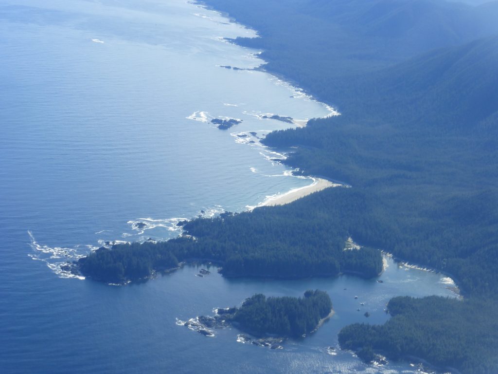
Columbia Cove, or Peddlers Cove, on the south side of Mᑫuqʷin/Brooks Peninsula 2018 – Lindsay Elms photo.
* Commemorates Captain Robert Gray’s ship “Columbia”, which anchored there June 1791 and July 1792. Appears as “Columbia’s Cove” on Robert Haswell’s sketch of Chickleset or Bullfinch’s Sound (Nasparti Inlet), and referred to by name five times in John Boit’s Log of the Union. (“16 May 1795: …at 3pm hauled into Bulfinches sound and at 6pm came to in Columbia’s Cove…” etc). Also called Columbia Cove on Public Works Canada mooring buoy’s report, 1979. Apparently called “Peddlers Cove” by some residents of Kyuquot.
Marble Meadows
12/13 July 1969
This was my first record of a trip in the mountains with Syd Watts, though I’m sure I met him on Mt. Cokely in 1968, without realizing that was the start of a long association.
Saturday July 12 – Up about 7:30 and away about 9 – we [John Gibson, Syd and Emily Watts] drove to the boat landing and parked the car above, put boat in water and crossed Buttle Lake to the foot of the trail up Marble Meadows and hiked up the trail to 2700 feet, where we pitched our tents at a pleasant level spot in big timber. After lunch we went on pleasantly light without our heavy packs, and marked out with ribbon the line of the trail which the Island Mountain Ramblers are to build up to Marble Meadows. At present it is finished from the lake (730 feet) up to 3100’ and it has to be completed up to the meadows at 5000’, with a 15% grade as the maximum, though actually it’ll be a good bit steeper than that. We positioned the ribbons up through the forest, and then roughly picked the best line up a break in a line of cliffs and then returned to camp. Sky was cloudy but most of the lower peaks were clear some of the time.
Sunday July 13 – Off at 8 a.m., again with light day packs, and after following the trail up to its end we continued to the meadows by a game trail, which is easier going than the line of the unmade new trail, but much less beautiful than the finished trail will be. There is a lot of snow still on the alpine meadows, but lots of flowers in the grassy patches and the snow is obviously going quickly now. We went up Marble Mountain (5800’) and Emily sat on a grassy alp while Syd and I went on to the summit, a pleasant scramble along a rocky ridge. The clouds receded a bit, a little snow flurry, and the sun came out and we had a good view around, and saw quite a lot of the Golden Hinde but not its top. Down again to Emily and then down to camp, collected our packs and on down to the lake, where a fresh south wind blew and we crossed it very slowly, Emily distinctly nervous of the rough water, and forlornly suggesting that I as a ‘sailor’, ought to run the boat in the such hazardous conditions. (Syd being the prophet without the honour in his own country) but he handled the boat most competently, and we arrived quite dry at the other side, loaded up and drove home. I got home about 11 p.m., and found Mary most worried and distressed, as we had both thought I’d be home much earlier, and I was subsequently somewhat unpopular.
Elkhorn, Ashwood and Maquilla Peaks
24 – 30 July 1976
This week was supposed to start with the Rees Ridge trip which was on the schedule, but since nobody turned up for that, other than our own regular party, we skipped it and went straight to our private trip, up the Elk River trail on the Saturday afternoon and climb Elkhorn by that easy but exceedingly loose gully route on the Sunday. I won’t go into details here as there is another Elkhorn trip on the schedule in September and that will doubtless be written up in the same Bushwhacker as this. It was a good day, with clear views, and we were 14 hours on the mountain, including an hour on the summit. On Monday we walked back to the highway and then drove on up to the Nimpkish Valley to camp at the end of Canfor’s Lukwa logging road, where the trail to Claude Elliot Lake starts. This logging road is currently being pushed up towards the lake as fast as Canfor can push it, while all that virgin forest in the Tsitika Valley awaits its fate. On the Tuesday Alan Robinson decided to have a late morning and then walked up to Claude Elliot Lake, and the rest of us set out at the crack of dawn for Mount Ashwood, the twin peaked mountain on the east side of the lake. We followed the trail almost to the lake, then turned left and ascended through open timber to 4000’. Then there was a short steep bushy section and we emerged at noon on a broad snow-covered ridge. From here the south peak of our mountain, the one marked on the map (Mount Ashwood 5722’) presented no problems and we ate our lunch on the summit. But it was obviously lower than the probably unclimbed north summit. This looked an imposing tower and the route leading to it was broken by cliffs, where the map had suggested a broad shoulder. We searched around, roped and eventually found a way onto the steep connecting ridge and descended toward the col between the peaks, but we were stopped by a break in the ridge just before reaching the col. The vertical pitch was little more than 30 feet but the rock was extremely loose. If there was time for a lot of gardening, while the “gardener” was held on a top rope, I think we could have climbed down, or if we had a spare rope and did not wish to cut off to retreat, which was probably just as well for as it was we didn’t get back to camp till 9:15 pm. Wednesday dawned cloudy and moist and we had a last day, and drove down to a pleasant spot by Klaklakama Lake, where we camped. On Thursday morning the clouds were still low and Alan Robinson and George Rushworth decided to go home. Syd Watts and I remained and were rewarded by a sudden clearing about 10 o’clock. We packed up and compensated for our late started by picking a mountain with a logging road to 3000’. Maquilla Peak (5973’), is on the east side of the Nimpkish Valley between Schoen Lake and Vernon Camp. After driving up the first half of our mountain, we started walking at 12:45; 1000’ through big timber, nice and open underfoot, then some transitional bush, but not bad going and soon we were out on a pleasant alpine ridge with flowers and snowpatches and heather and rock. We reached the top at 4:15 p.m. and spent about 45 minutes relaxing up there before strolling back down again., with a pause to watch a rather dramatic storm doing its stuff on Rugged Mountain across the valley. Altogether a successful week, even though we didn’t make both peaks of Ashwood. The view over the broad expanse of the Tsitika Valley, still unscarred by logging, was a notable feature of our Ashwood day. And beyond the Tsitika we looked down to Johnstone Strait, and beyond that the Coast Range with Mount Waddington dominating the far horizon. That day was one of those exceptionally clear and brilliant ones, which stand out in memory for a long time, and whet the appetite for more.
Maquilla Peak 2017 – Lindsay Elms photo.
Bonanza Peak (Mt. Ashwood north)
16/17 June 1979
Saturday June 16 – In 1976, when Syd Watts, George Rushworth and I climbed the south peak of Mount Ashwood (5722’), with the name and survey point on it, we only realized on reaching that summit that the north peak is actually higher. A careful counting on the map contour line confirmed this, and now, nearly three years later, the north peak has graciously accepted our advances. We drove up the new highway in pouring rain on the Friday evening and camped by Bonanza Lake (Crown Zellerbach campsite). Saturday dawned moist and misty and we were in no hurry to get going. After some to-ing and fro-ing along logging roads looking for the best approach to our mist shrouded mountain, we parked the Landrover on a spur from C.Z.’s main road south, and took to the bush about three miles west of our summit. The lower slopes, pleasant open forest with no bushwhacking, led beautifully smoothly up a ridge to timberline and about 2 p.m. we reached a snowy dome and had a brief glimpse of our summit through a hole in the mist. On a long snowy ridge with some down and up again and at 6 p.m. we were at the base of the final rock peak, and in bright sunshine. Here Syd sat on a rock and worked out a much better way back to the car than the way we had come, while the rest of us reconnoitered the rock ledges leading towards the summit. We rejoined Syd at 6:45 p.m. and followed the route he suggested, down to the Bonanza River and then along the bench beside it, in spruce and hemlock forest where the going was good, as he expected. We reached the Landrover at 9:15 p.m. and were soon back in camp.
Sunday June 17 – Next morning was clear and fine and we were away at 6:30 a.m., returning to the mountain by the way we came down the day before with minor variations. We reached the bottom of the final rock tower and roped there about 12:30 with Rick Eppler and Ben Peterson on one rope and Syd and I on the other. Climbing was easy but exposed at first as we traversed ledges around the west face of our peak to gain the south ridge, up which we proceeded without difficulty, reaching the summit at 2:10 p.m. The summit is a large detached block which looks as if it might roll down toward Johnstone Strait one of these days. We built a cairn and left a record in it. After basking in the sun up there for an hour or so, we descended by the same route, getting back to the Landrover at 7:15 p.m. This summit appears to be the highest point of the Bonanza Range, so it seems odd that the surveyors ignored it, placing the name, Mount Ashwood, on its lesser sister half a mile to the south. To give it its due, our peak should perhaps be named Bonanza Peak.
Bonanza Peak from near Mt. Ashwood 2016 – Matt Lettington photo.
Zeballos Peak – 1st ascent
27/28/29 July 1983
Tuesday July 26 – Raining and low cloud when my alarm went off at 5 a.m., and it continued like that all day, with occasional let ups in the rain. We got up about 8 o’clock and had a leisurely breakfast, and when the rain let up went for a walk up the logging road on west side of Wolfe Lake. Back to the camper just before a heavy rain set in. After lunch the rain let up a bit and we walked down the Zeballos Road to a bit of unlogged old forest and walked through trees to the river and back to the camper by the way we come. And the rain poured again while we set up the camper. The only good thing about today is that we are not in a rush’
Wednesday July 27 – Again my alarm went off at 5 a.m. and I walked out to inspect a valley filled with cloud and rain, so back to bed. Eggs and bacon again soon after 8, and then we sat in the camper and read while the rain beat on the roof. After lunch we set out to drive to Woss for gas but changed our minds, and went to Port McNeil instead, and after getting gas drove down to Zeballos, where cloud and drizzle filled the air and we only saw the bottoms of the mountains. We walked out to the end of the dock and drove back to the valley and parked for the night on the inactive logging spur running up the north side of the valley north of Zeballos Peak. Still hoping the weather may clear and let us get up that mountain tomorrow.
Thursday July 28 – At last a possible looking morning. Our mountain and its friends and relations were still shrouded in cloud, but at least there were large areas of clear sky. We got up at 5 a.m. and were on foot at 6:17, having breakfasted well. We walk down to the main road and up the other one on the south side of the valley. Reached the end of the road at 7 a.m. and took the same route up the lower part of the mountain as last year (see June 27 1982). The bush was very wet, like last year, and soon we were too. We reached the 3000’ point where we turned round last year at 9:30 a.m., and sat there for about an hour hoping the clouds would clear. They did, partially, from time to time, and we decided to take a route up a long snow slope left of the ridge. The ridge itself, which was all snow last year, was now steep slabby rocks and not all that inviting. We kicked steps up the snow slope and from the top got up onto the 4700 knob at the top of the ridge and down the other side to the col leading to the summit ridge of our mountain. There was an attractive little lake with icebergs on the col. The summit ridge was long, and in general steep on the left side and less steep on the right – as seen from the col. The actual summit mass was concealed by swirling mists until just before we reached it, by traversing round the easy side to find the only easy way onto it. The actual summit was a narrow knife edge ridge with sheer drops down both sides. We stayed there only a few minutes – glimpsing bits of views through holes in the clouds, briefly. We saw quite a chunk of Rugged and the Haihte Range, minus their tops, and the lesser summits of our own mountain, and little bits of coast beneath dash rain clouds and then while we ate our lunch the rain began. Reached summit about 12:15 and left about half an hour later. We stopped several times on the way down, waiting for our summit to clear, and eventually it did, when we were at the 3500’ knob. Below that, on the ridge, we heard a thunderous roar and I just saw the last blocks of a spectacular ice avalanche coming down the steep gully to the right of our ridge. (We’d used the slopes to the left of the ridge). On the lower part of the mountain, in the bush, Syd had noticed a band of large hemlocks which he felt might provide a much better route than the one we’d used coming up. He was right, and after descending the one easy way down the cliff at about 2500’, we turned left and followed his route, missing all the huge boulders and wet huckleberries. We crossed the first creek at about 2500 feet and then plain sailing all the way down. I found three chanterelles which we had for supper. Back at the camper at 6:30 and proceeded to Wolfe Lake where we camped for the night.
Addendum:
By Lindsay Elms
Zeballos Peak (1576m) is name after the Spanish Lieutenant Ciriaco Cevallos y Bustillo. He was assigned to cartographic work on Alexandro Malaspina’s Expedition to the west coast of North America where he spent a month in the Spanish outpost in Nootka Sound in 1791. The first ascent of Zeballos Peak was probably in 1931 when the BC surveyors Alan Campbell and H.E. Whyte set up a station on the summit. Eight years later the Geological Survey of Canada sent a team who also made a survey from the summit. On 31 August 1947, Walter (Red) Moffat and Bill McDermot, both employees at the Privateer Gold Mine in Zeballos, made an ascent of the peak from Zeballos Lake. Neither were mountaineers but because the looked at it every day (when it could be seen) it was always in the back of their minds. After John and Syd’s ascent on 28 July 1983, they returned a month later in better weather (21 August) and climbed the peak again this time with Rolf Kellarhalls and his son Markus, and Rick Eppler (see Island Bushwhacker summer 1983 p.5.)
Mount Juliet
29/30 July 1983
Friday July 29 – Up at 6:30, a fine morning with low cloud in the valley which soon cleared leaving summits clear. We [ John Gibson and Syd Watts] set off after breakfast, got gas at Woss, and came on to the Montague Creek logging road (RL640) running up the valley northeast of Juliet. We parked near the end of the logging road, about 2400’, and started walking at 10:30 to the end of the logging road, and then up to the northweast ridge of Juliet, a steep forested ridge with cliffs which we left on our right and then followed a deer trail up a gap in the defences, which brought us out in the alpine terrain about 4000’. Thence a very pleasant ridge, broad and open, led us to the summit, with snow patches near the top. Reached summit at 2:45 p.m. (5370’), and attractive and comfortable summit with heather and scrubby trees and room to sit down and wonder around. Magnificent views of coast range to the east, Victoria and Warden fighting clouds off to the south, the Sutton Range, Schoen, Cain, Hapush, Ashwood, Rugged and possibly Zeballos Peak, but it didn’t look quite right, so I took a bearing. We left the summit at 4 p.m., and descended by the north ridge, a broad and beautiful alpine ridge with attractive pools, which clearly descended to 4000’ where timber began. A most attractive little lake at 4000’ in the timber. We walked over to a bare knob where a lightning fire had burnt off the timber 30 or 40 years ago and peered over the precipice to Owens Lake below. Only saw a tiny bit of it, with a wrecked aircraft upside down on the beach, with its tail broken off. Looked as if it had been there sometime. We headed north along the ridge, clearly contouring down, until we got to 3000’, following deer trails, then turned down and made for the logging road, which we reached at 8 p.m., and walked up to the camper reached at 8:15 p.m. A most satisfactory day.
Saturday July 30 – A leisurely breakfast and we started walking about 9 a.m., up the logging road we walked up before (June 25) towards Owens Lake. We made our way through the logging slash at the end of the road, and then into the big timber and through a sort of tunnel under and between enormous boulders, and out into dense undergrowth leading down to the lake. But the water level had dropped about three feet since we were last there, so we were able to get right down to the waters edge, and then along on boulders is a smoothly sloping beach which we followed along the west shore of the lake to a beautiful green meadow at the far end. We passed the remains of the crashed aircraft we looked down on yesterday. Quite an old wreck, a little Cessna I think, with engine and instruments and all removed – just the shell of crumpled and broken fuselage and wings. The lake was inhabited by a large flock of geese – we counted 50, which swam around and watched us and kept a safe distance. We walked around the meadows and took pictures and then back the way we came – the other shore looked less good going and was in deep shadow. The cliffs on that side were most impressive, quite sheer for some 2000 feet and we could we could see the place where we’d looked over yesterday evening. We stopped half way along the shore on the way back and had a wash, and for me, a very brief swim.
Mt. Juliet 2021 – Lindsay Elms photo.
Sebalhall Ridges and Conuma Peak
26/27/28 August 1989
Saturday August 26 – Away about 8:30. Leaving tent in situ (near a bridge across Sebalhall Creek south of Vernon Lake). We went as far as we could go up the road to the west fork of Sebalhall Creek. Road no longer used for logging and had several 4 wheel drive sections where water had partially washed it out. From the point where we parked on the east side of the creek (the bridge to the other side was washed out), we walked starting at 9 a.m., up the valley and across on logging slash to the road on the other side, and then up a steep and narrow gully, to the ridge, at a very narrow col at about 3400’, between Sebalhall Creek and the unnamed side creek with the little unseen lake [Emerald Lake] in it. The col itself was bushy, and the unnamed mountains to the right looked steep and bushy and full of bluffs. We chose the unnamed mountain to the left, and very soon emerged from bush into open alpine slopes, heading very pleasantly up to the summit at 4100’, with views of mt. Bate, Stevens peak, and the unnamed peaks between us and Mt. Alava. Also views of the Strathcona Park mountains, and the Sutton Range from Mt Alston to Sutton Peak, Watchtower Peak to Mt Schoen, with Victoria and Warden beyond and to the right of Alston. We stayed up there about two hours. On the way down we found a very attractive potential campsite for energetic types who are prepared to backpack up one steep gully, on route perhaps to Mt Alava and Bate. We also had a fine view down Conuma Creek, but didn’t see Conuma Peak as it was hidden, I think, by Leighton Peak. Our descent down the gully was slow and circumspect and when we finally reached the deactivated logging road on the west side of our valley, after struggling down the dry creek bed plugged with logging slash, we walked down the road to where the ridge had been, and back up our road to the Landrover. Near our campsite we found what would have been a much nicer one, by the river, with access to the river. We went and washed there, total immersion for me and it was cold, and back to our campsite around 6 p.m. for supper. Our actual walk was about 8 hours, so quite a mild day, but it felt quite strenuous.
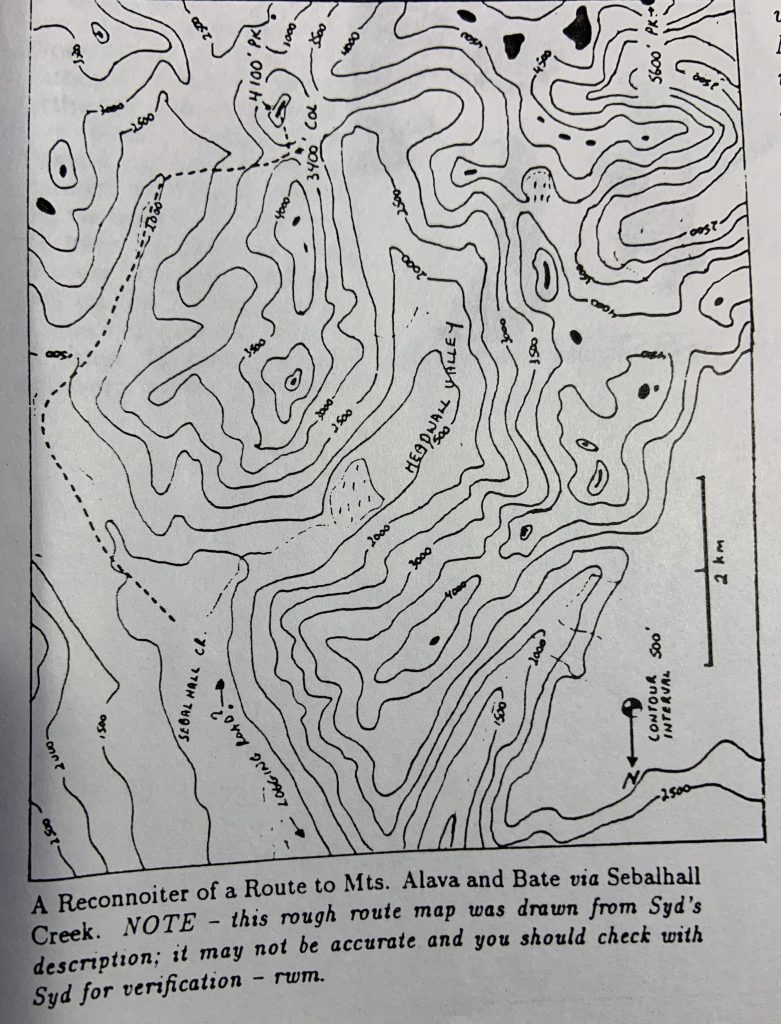
Sketch map of the Sebalhall area.
Sunday August 27 – A cloudless morning and we slept in till 9 o’clock. Then spent the morning exploring the east fork of the Sebalhall Creek, a logging road that led steeply up to a high valley with two little mountain lakes in it, one at 1900’ and the other at 2100’, both rather devastated by logging. Beside the road we found an old sign saying “We only load the big ones.” All the rest lay on the ground rotting. Back down to Vernon Lake where we had lunch and I had a swim, at the picnic site at the south end. Then on down the Nimpkish Valley to the junction with Tahsis Road, and up the Tahsis Road. We turned off just passed Upana Lake on the logging road which we thought might lead us to the long east ridge of Conuma Peak. But first we came to the parking space for Upana Caves – limestone caves, which we didn’t have time to explore. There we met Gareth Wood, who wintered at the south pole and now manages Strathcona Lodge, he was about to take a look at the caves with two others. We went to the end of the logging road, and the approach to Conuma Peak by that route looked long and bushy and fraught with hidden bluffs, so we returned and continued on the dusty Tahsis Road, down the hill, and turned off the first logging road to the right (H-32), which we thought was going up Conuma Creek on the other side of Conuma Peak, but later found was an unmarked road up an unnamed creek immediately west of Conuma Peak and giving much closer access to it. We camped where a side road crosses the creek, after investigating a bit further up the road.
Monday August 28 – A foggy morning but the fog had a bluish tinge – actually it was low cloud just above our campsite. We drove up to the end of the very rough in places road, at about 2200’, and parked there, the mist rapidly dispersing and promising a beautiful day aloft. We started walking at 8:30, up through fairly well tidied logging slash – you could actually see and tread on solid ground most of the time – and into timber after about 500’. We had intended to go up through timber to a broad alpine ridge at 3700’, south of Conuma Peak, but we kept a bit too far to the right and got straight onto the mountain itself, a very steep, very bushy approach, dodging between rock bluffs to work our way up to the west ridge of our mountain, on which we emerged at around 4000’, with cliffs below us and a view down over the broad alpine ridge we’d intended to come by, and Nootka Sound under sea fog beyond. We worked our way on up the west ridge of Conuma, and came to one thin spot where it was narrow with sheer cliffs on both sides and a rather exposed little creek up the middle. We continued steeply up the narrowing ridge to a point where we arrived at a gap between a rock pinnacle and the main ridge, with steep cliffs on both side and a V-shaped groove up the middle which gave access to a short chimney with a very convenient tree near the top. The tree provided a good handhold and a belay. This rather exposed pitch was the only place on the way up where we had to use my 7 mm line for protection. From there, it was easy going to a very satisfactory summit, which we reached at 1 p.m. from the west end. To the west, Mt. Alava and Bate and Stevens Peak looked deliciously seductive. Rugged peeped over the top of Mt. McKelvie, I think. To the north we could see the Bonanza Range, and south of it the Sutton Range from Mt Schoen to Mt Alston and Victoria Peak towering behind and to the right of Alston. And further south were our old friends in Strathcona Park. Our summit was a short, roughly horizontal ridge. Off the east end it dropped over pleasantly alpine terrain to a broad alpine plateau with little pools, about 900’ below us, from where it looked like we might find a route back to the valley that was less steep and less bushy than the way we came up. If there were no hidden bluffs we couldn’t get down. If there were, we could see that they would be in the first 500’ down from the summit, so we decided to take a chance and come back up if we had to. There were two bluffs, but we were able to scramble down the first with no difficulty, and the second was easy too except for one short 20’ pitch which we rappelled down on my 50’ of line. Down at the bottom of the main ridge was a lovely undulating alpine plateau with little pools. We had a swim, admired the most impressive view of Conuma Peak, looking a lot more forbidding than it actually was. Then down into the bush to the head of the valley, from which we emerged to tackle the inevitable few minutes of logging slash, and back to the Landrover at 6:30 p.m., just 10 hours for the trip.
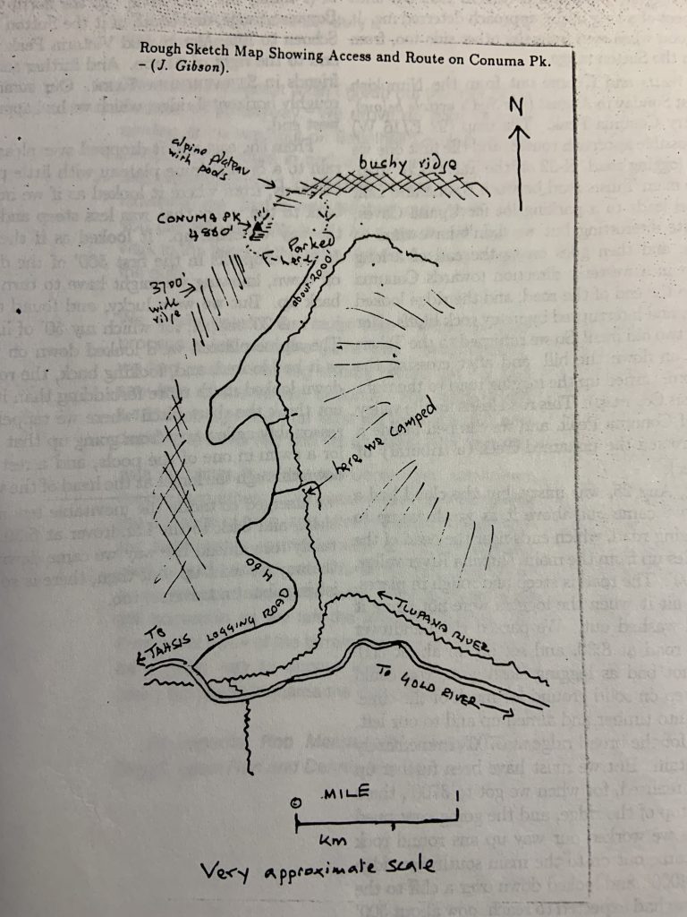
Sketch map showing access and route on Conuma Peak.
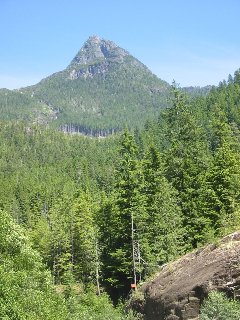
Conuma Peak 2020 – Lindsay Elms photo.