1970
ACCVI executive:
Chair – Syd Watts
Secretary/Treasurer – ??
Events:
May 16/17/18 – Combined ACCVI and IMR trip (40 members) to the Elk River valley led by Syd Watts, John Gibson, Jack Shark and John Cowlin. Several ascents of Elkhorn South Mountain.
August 1-8 – Syd Watts, Bill Lash and Roger Neave led a week-long camp at Memory Lake.
?? – Syd Watts is the leader of a trip up Mt. McBride from the Wolf River.
?? – Tom Volkers and Mike Walsh climb the Needle spire next to Rambler Jr.
?? – Tom Volkers and Mike Walsh climb the South Ridge of Elkhorn Mountain.
August – Shawnigan Lake School complete the Wheaton Hut on Marble Meadows.
September 5/6/7 – Marble Meadows trail officially opened by Syd Watts and Bob Tustin with the uncorking of a bottle of Champagne. B.C. Parks officials were unable to fly in due to bad weather.
October – Carl Lund and Brian Foan make the 1st ascent of Augerpoint South [Sid Williams Peak].
October 18 – Hike led to protest logging on Mt. Arrowsmith.
November – ACCVI members Roger Neave and Michael Penn led a trip to Langtang, Nepal with 32 people from the Alpine Club of Canada. (Reported in The Daily Colonist Sunday May 2, 1971. p.22.)
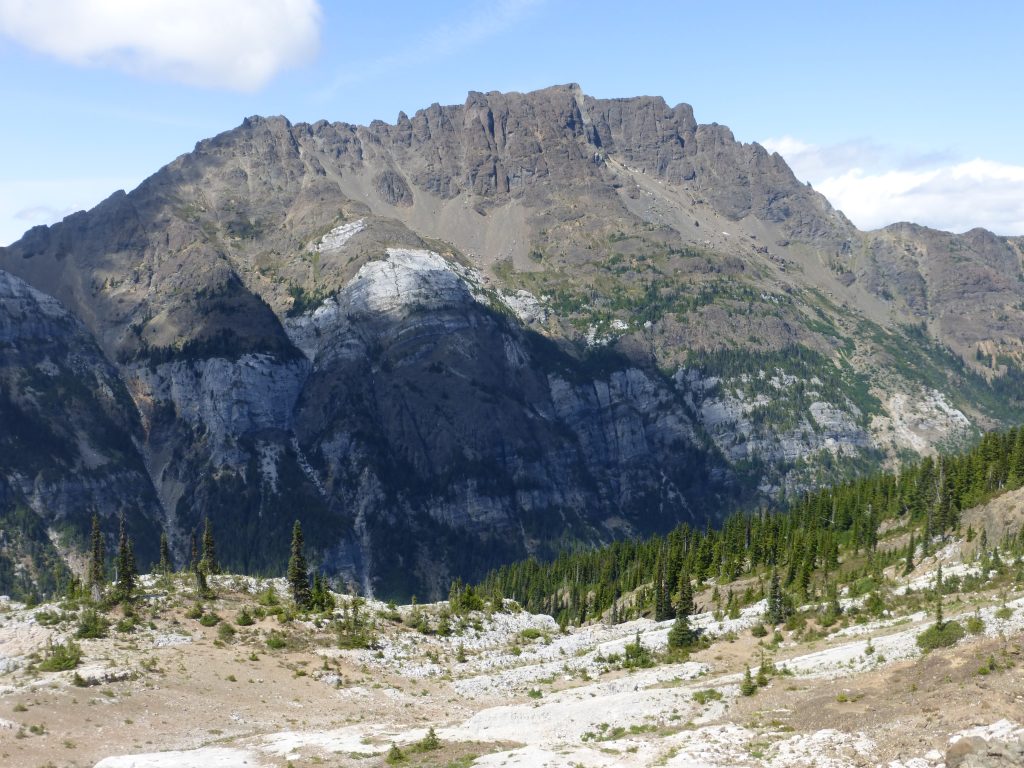
Climbs From The Elk River Valley
May 16/17/18, 1970
Reported in The Timberline Tales, newsletter of the Island Mountain Ramblers, No. 6, Jan. 1971, p.14/15.
By John Gibson
Leaders: Syd Watts, John Gibson, Jack Shark, John Cowlin.
About 40 members of the Island Mountain Ramblers and Alpine Club of Canada met at the Courtenay Court House on May 16th. We proceeded to the Gold River road, parking cars and shouldering packs where the Elk River valley and the road part company. Thence we followed the trail beside the Elk River, and were properly appreciative of all the work done upon it by Jack Shark and others. It has been suggested that further improvement of this trail, with building of bridges across the side creeks, would be a good centennial project for the IMR’s, giving public access to a remote and beautiful area of Strathcona Park. Our hike in was eventful. Wet and mild weather had swollen the creeks, necessitating the crossing of a number of slippery logs. Some walked boldy, some sat astride, some crawled, and one of the two (including this writer) were involuntarily immersed. At Butterwort Creek, the log, though solid, was high and a safety line seemed a good idea. While Syd Watts was fixing that, the raging torrent somehow snatched his ice axe. His fruitless search for that (it was later recovered however) had scarcely begun when a runner from further back came up with the news that someone had broken a leg. Some of us returned and a short way back found Joyce Clearihue, the only doctor in the party, lying on the ground with her leg neatly bandaged and splinted. A simple slip on a part of the trail with no apparent hazard other than protruding roots, caused the accident, showing how easily these things can happen, even to experienced climbers. Joyce had told the first aiders what to do, and was equipped with the proper pills for minimizing pain. Hank Wilkinson and Bob Paul went back as fast as they could, to inform the police at Gold River, the main party went on to the campsite higher up the valley, and a group stayed with Joyce, and awaited help from above, which they duly arrived in the form of a large twin-rotor Search and Rescue Helicopter. This machine landed with impressive aplomb on the gravel flats beside the creek (luckily only a few yards from the place where Joyce fell), disgorged Hank and Bob, and bore Joyce off to Campbell River, whence she proceeded to Victoria by taxi, notwithstanding the broken leg! The rest of us continued up the valley to the campsite, Syd Watts now re-equipped with Joyce’s ice axe. We camped on the gravel flats beside the creek at about 2500 feet. It rained a bit in the night, with a dusting of new snow higher up, but weather was good in the morning and an assortment of parties set out to climb an assortment of peaks. Syd Watts probably had the largest party, headed for Elkhorn Mountain. He was joined by Jack Shark and his party, who decided snow conditions were not suitable for their planned ascent of Rambler Peak. They were slowed up on Elkhorn by soft snow lower down, and then about 800 feet below the summit they were turned back by hard snow that would have necessitated step cutting, for which there was not time, with so large a party. John Cowlin led a group to the summit of Elkhorn South Mountain, and I, billed by a typographical or editorial error lead a sort of “Eigerwand” to the north summit of Mount Colonel Foster, soon disillusioned my party about my capacity for that sort of thing (if they had any such illusions after my demonstration of falling off a log!) and we set ourselves a more attainable objective at the Colonel’s south end. Ralph Hutchinson, Robin carter and Carl and Carolyn Lund went off to reconnoiter possible approaches and routes on the north peaks of Colonel Foster, and a party of seven, comprising Roger Neave, Bill Perry, Bryan Lee, Steve Webber, Roger Chicoigne, Richard Millar [Millar made the first ascent of Tlatlos Peak with Walter Hrybko and Tony Coley on 28 April 1973] and John Gibson set off for the ordinary route to the south peak of Colonel Foster. We all took turns breaking trail in the snow and some step cutting was needed in the gully known as the “hourglass.” Above the col the snow was more softened by the sun and we proceeded up snow and easy rocks to the first summit, with we reached at 1 p.m. With binoculars we watched climbers approaching the summit of Elkhorn South, and others toiling up a snow gully on Elkhorn itself. We contended ourselves with the first and easier of Colonel Foster’s two southern summits, and did not need to rope. The traverse to the second and higher peak looked distinctly formidable with its plastering of snow, and though it is said to be easier than it looks, we all agreed that we should take too long to get there and back. The going, in spring snow, was more strenuous than difficult, and much of the credit for picking the best line should go to Roger Neave. The descent, on afternoon softened snow, was swift, simple and moist, and we were back in camp around 5 p.m. The whole party hiked out along the trail back to the cars on Monday morning, with some more fun and games at Butterwort Creek, where Gertrude Smith did a spectacular plunge from the high log to the creek, emerging very wet, but fortunately none the worse.
Elkhorn South Mountain
May 16/17/18, 1970
Reported in The Timberline Tales, newsletter of the Island Mountain Ramblers, No. 6, Jan. 1971. p.14/15.
By John Cowlin
With the torrent of water in the Elk River, we hiked downstream from the fork in the river approximately ¾ mile south of the lake below Mount Colonel Foster to 200 yards downstream from an avalanche slope off Puzzle Mountain. Here we were able to ford the river and entering the timber, hiked up the second creek bed south of the fork mentioned above. This bed proved an easy route, with very little scrambling and terminated at a knoll at elevation 4900 feet, where we had our first lunch. From here it appeared practical to climb Elkhorn itself, – in fact we heard Syd Watts and his party just above us. With our destination to the southeast, Ken Stockhausen, Keith and Jill Waterfall [Keith was a dentist in practice with Alan Robinson in Duncan], Katherine Capes, Doreen and I pressed on, while Philip Vander Groos, Beryl and Noel Mottershead decided to retrace their steps after watching another party climb the east peak of Mount Colonel Foster. In crossing to Elkhorn South Mountain, we encountered soft snow, which noticeably hardened as we gained altitude. Immediately below the summit, it was so hard that it was difficult even to kick a slight indent. We reached the summit at 3:30, 7½ hours after crossing the Elk River, but returned in under 4 hours, including looking for a way down a rock face, and wading across the Elk River again. To our surprise, the water didn’t seem quite as icy on the return, even though the lake a mile upstream was stilled covered with ice. Another party also climbed Elkhorn South, making the summit at shortly after noon.
City Woman Rescued On Mountain
Reported in The Daily Colonist Sunday May 17, 1970. p.25.
Victoria dermatologist Dr. Joyce Clearihue was taken off a mountain near Gold River Saturday afternoon by an Air-Sea Rescue helicopter and taken to hospital in Campbell River, with a fractured leg an Air-Sea Rescue spokesman said. A member of the Vancouver Island section of the Alpine Club of Canada, Dr. Clearihue was planning an October hike through the Himalayas [to the Langtang region with the ACC]. Two years ago, she hiked in Mexico, and last year she went to the north end of Vancouver Island.
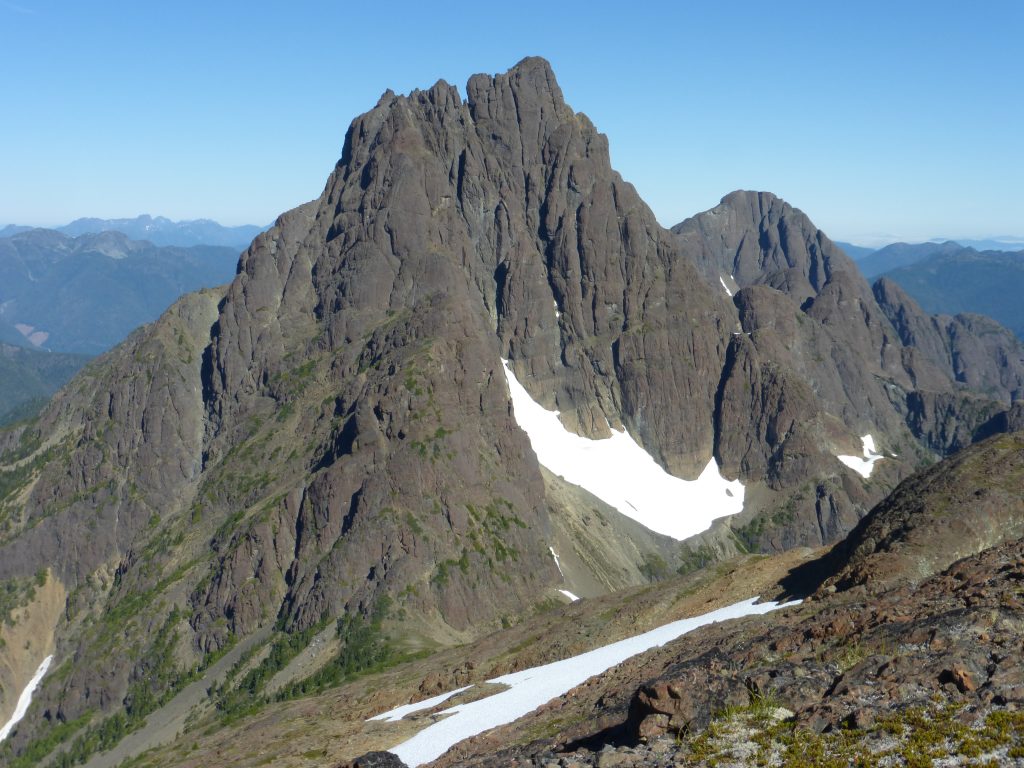
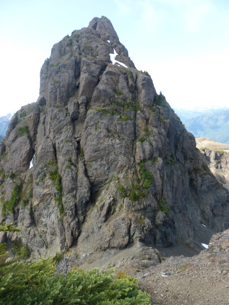
The South Peak of Elkhorn Mountain
Reported in The Canadian Alpine Journal Vol. 54, 1971. p.91.
By Tom Volkers
Summer 1970 – Mike Walsh and I [Tom Volkers] left camp at the lake below the east face of Mount Colonel Foster at 7 a.m. and descended about 400 feet into the Elk Valley. Opposite the first large gravel bar we came to, we started up a narrow timbered ridge. The ridge ended in small bluffs at the edge of the alpine, but there was no problem finding a route through and around them. At 9:50 we were at the col between Elkhorn South (6,526 feet) and the South Peak of Elkhorn Mountain (7,000 feet). We then proceeded up the south ridge which is quite difficult and narrow, with lots of exposure. Part way up the first part of the ridge we found a piece of rope that had been left there by a previous unsuccessful attempt. The climbing was excellent, mostly very exposed class 3 plus and class 4, with the odd pitch of class 5 near the summit. We shared the lead on the class 4, but Mike led the class 5. We were on the top of the South Peak of Elkhorn at about 3 p.m. and built a small cairn. An overhanging rappel and a smooth slab requiring the odd direct aid piton appeared to be the only difficulty that separated us from an easy class 3 ridge that led to the main summit (7,190 feet). A quick check of supplies showed us that we lacked the iron to continue, so we turned back, descending by the same route as the ascent. We arrived back at our camp at the lake at 8:10 p.m.
The South Ridge of Elkhorn from Elkhorn South 2016 – Lindsay Elms photo.
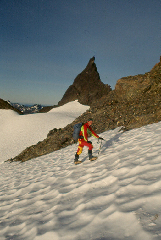
The Needle
Reported in The Canadian Alpine Journal Vol. 54, 1971. p.91.
By Tom Volkers
Summer 1970 – The Needle [the slightly lower rock spire next to Rambler Junior] is a spectacular tower located on the eastern end of a ridge south of Rambler Peak, near the head of the Elk River From a snowfield between eh objective and Rambler peak, climb 100 feet up the east ridge and traverse to the South face. Follow a crack system up as it becomes a chimney and then a corner. From top of the corner, the summit ridge is easily accessible. Hanging on to the crest, traverse up and left to the summit block, which is of a size more suited to handing than standing on. First ascent by Mike Walsh and Tom Volkers 6600 feet, Class 4.
Dave Hilling in front of Rambler Junior 1994 – Lindsay Elms photo.
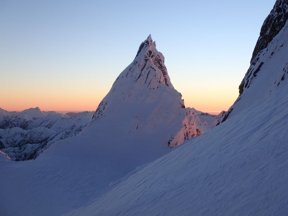
Rambler Junior in winter – Josh Overdijk photo.
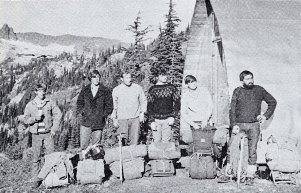
Memory Lake Camp
August 1 – 8, 1970
Reported in The Timberline Tales, newsletter of the Island Mountain Ramblers, No. 6, Jan. 1971. p.16/17.
By Syd Watts
Leaders: Syd Watts, Bill Lash, Roger Neave.
A sunny Saturday morning saw half of our party fly from Campbell River to Memory Lake, taking with them the packs of the other half, who chose to walk from Buttle Lake. Spectacular views of the Forbidden Plateau, Cruikshank Canyon and the blue alpine lakes tucked in a cirque with a magnificent 800-foot waterfall greeted them. The pilot’s approach directly over the waterfall thrilled them but earlier on the flight they had been impressed even more by his ability to find what was to him an unknown lake, by way of B.C. road map. Base camp was set up on an attractive alpine point on the northwest corner of the lake. Hikers from Buttle Lake started up the ridge between Ralph River and Shepherd Creek at 8 a.m. and reached Memory Lake camp at 8 p.m. Their route over high alpine flower ridges and snow slopes was highlighted by watching a mother bear washing her cub on a snow slope, much to his annoyance, as she had to call him back twice to finish her job. After this she slid down the snow slope on her stomach using her paws to push herself faster. It must have been most refreshing, considering the heat of the day. The first half of the week’s weather continued sunny and hot and climbs were made of the Comox Glacier, one by the main north route above Moving Glacier and one by a direct route from the Mirren/Milla Lake col. On Wednesday [August 5] two higher camps were set up, one on Memory Lake col and one on the main ridge above Milla Lake. Wednesday night it rained hard and blew a gale. Thursday noon when it cleared briefly the group at the Memory Lake col packed out over Rees Ridge and Aureole Snowfields to a more sheltered campsite in alpine meadows above Delight Lake. The party camped above Milla Lake climbed Argus Mountain in cloud on Thursday [August 6] and hoped to climb The Red Pillar on Friday. However, Friday was very wet and windy. The Delight Lake group spent a comfortable day under alpine hemlocks by a big fire eating surplus food. The hikers on the Milla ridge did not fare as well. As Ray Paine put it: “I didn’t mind sitting on my air mattress doubled up but when my candle floated by it was time to find drier quarters.” Saturday morning it cleared at 8 a.m. and the plane arrived promptly to take out the remaining hikers at Memory Lake camp. The Milla Lake group packed out to Buttle Lake, arriving at 9 p.m., while the Delight Lake group had a leisurely trip out, arriving at 5:30 p.m. Both walking parties agreed that the last few hundred yards of the burn would benefit greatly by a half day’s work. While the weather forced cancellation of planned climbs of Mount Harmston and The Red Pillar, everyone enjoyed the trip and it is hoped to repeat it another year.
Wheaton Hut/Marble Meadows
Mountain Shelter Project
Reported in the Shawnigan Lake High School Year Book 1970. p.62.
At 5 a.m. on Saturday, 29th August, the last nail was driven into place and a two-year project was complete. The Billy Wheaton Memorial Hut, which began to take shape on the drawing boards of the 1969 Grade II Draughting Class at Shawnigan Lake School, was prefabricated in the workshop by their successor, the 1970 Draughting Class. It was finally erected by the same class in the summer of that year. This mountain shelter, the first of its kind on the Island, stands on Marble Meadow Plateau in Strathcona Provincial Park. The site is 5,000 feet above sea level and is a day’s hike from the Golden Hinde, Vancouver Island’s highest mountain. Built as a Memorial to Billy Wheaton, who was killed climbing in the Austrian Alps, the hut is a gift to the province and it’s intended for the use of all. The first boys involved in the project were the members of the ’69 Draughting Class: G. Williamson, M. Forrester, A. Binz, Godwin, Williams and Bailey. From their drawings of an adapted Batzer design the ’70 Class: Jim Boughton, Des Bazett, Alan Gibson, Chris Janeway and Vic Kimola, began constructing the pre-fabricated parts. This task was completed by the end of the summer term. This same group (with the exception of Gibson who was working in the Northwest Territories), returned to the school on August 24th. The following day, accompanied by Mr. K.J. Hickling (Head of Industrial Arts), Mr. R Smith (Head of Art) and Mr. John Hilton, the party moved north to Buttle Lake. From Buttle Lake a helicopter, provided by the Park’s branch, lifted the hut parts and the building party to the Marble Meadows site where the hut was erected. Five days later the group walked out to Buttle Lake, where a ferry service arranged by Mr. P. Kearns, was available to pick them up and return them to civilization. The Billy Wheaton Memorial Hut now stands as a fitting tribute to the young man after whom it was named and as such a place of rest and shelter for climbers, walkers and all others interested in the outdoors. Mr. George Wheaton, the boys of both classes, their director and all others who assisted with this project are to be congratulated on the imagination and persistence which they so clearly exhibited in bringing this project to its successful conclusion.
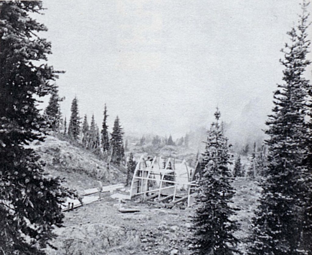
1970 Wheaton construction.
1970 Wheaton group.
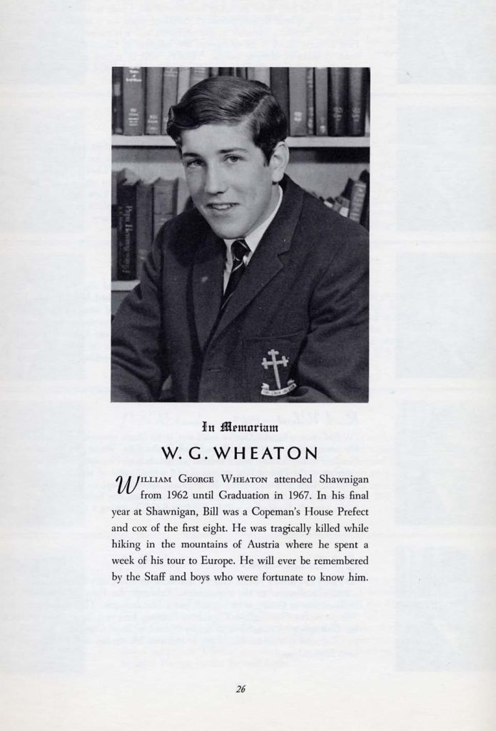
In Memoriam
W. G. WHEATON
WILLIAM GEORGE WHEATON attended Shawnigan from 1962 until Graduation in 1967. In his final year at Shawnigan, Bill was a Copeman’s House Prefect and cox of the first eight. He was tragically killed while hiking in the mountains of Austria where he spent a week of his tour to Europe. He will ever be remembered by the Staff and boys who were fortunate to know him.
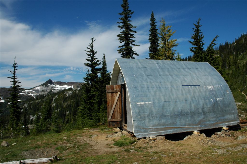
Wheaton Hut 2016 – Lindsay Elms photo.
Addendum:
William (Billy) George Wheaton graduated in June 1967 and embarked on a European Tour for the summer with his school. Billy Wheaton was on the schools rowing team and after the rowing competitions were over, all the boys on tour (rowers, along with those who had gone over with the school’s track and field and squash teams) divided into groups and went on different sightseeing tours. Billy went with one Shawnigan Lake School staff member and a small group of fellow students to the ski village of Hochsölden in the Austrian Alps. On August 7, while hiking the mountain Gaislachkogl, Billy tragically slipped and fell over the edge of a section with a steep drop-off. In 1970 seniors in the Shawnigan Lake School’s Industrial Arts class designed and prefabricated a structure which measured twelve feet by sixteen feet by ten and a half feet high. Materials for the cabin were donated by Billy’s father, George Wheaton. At the time the Head of the Industrial Arts class Ken Hickling said: “Billy was a keen climber and the boys at the school wanted to honour his memory in some way.” On August 25, B.C. Parks flew the materials in to Marble Meadows and a party from the school undertook the construction of the prefabricated parts over the next five days. In October 2007 a party which including the woodwork teacher from Shawnigan Lake School was flown in to assess the hut and come up with a plan for restoration work. In 2008 a party removed the old cast iron stove and re-leveled the hut which had been gradually sagging for many years.
Marble Meadows
By Lindsay Elms
Marble Meadows offers hikers, climbers, botanists, photographers, geologists and paleontologists, a fascinating place to explore. Once located at the bottom of the ocean, plate tectonics and sea floor spreading, volcanism, sediment accumulation, mountain building, glaciation and erosion, has shaped Vancouver Island to its present form. As a result of underground forces, Marble Meadows was thrust to over five thousand feet. Marble Meadows sits on about three hundred metres of limestone, called the Buttle Lake Group by geologists, and was slowly deposited on this shallow submarine platform during the Permian Period 360 million years ago. Although thin relative to the volcanic rocks of the park, the limestone is a prominent and unique feature. It is strikingly visible as a white layer separating two dark-coloured volcanic units. The limestone is made up of coarse grains broken from the skeletal remains of crinoids or sea lilies. These are now preserved as fossils and are cemented together by fine crystals of the mineral calcite. There are features characteristic of limestone erosion by underground chemical solution to be found on Marble Meadows as well. Groundwater percolating through these rocks dissolves the limestone and this results in unique karst erosional features including sinkholes, and disappearing and reappearing streams. This type of topography is developed to extreme in the Karst area of Serbia and Montenegro, hence the name given to this type of erosion feature. The study of fossils is called paleontology and is an important branch of geology. Fossils are the remains or traces of animals and plants that are preserved in rock. To be preserved, an organism must first be buried rapidly in sediment. Even then, it is usually only the hard parts, such as bones, shells or their impressions, which we find as fossils today. During and after burial, the original material of the fossil may be re-crystallized or even dissolved away and replaced by a new mineral such as silica or calcite. Fossils tell us about forms of life that existed in the past, the conditions in which they lived and how they evolved over time. These fossils can also be valuable indicators of the age of the rocks in which they occur. The most common fossils seen in the rocks of Strathcona Park are the small, doughnut-shaped fragments of crinoids. These make up a large proportion of the Buttle Lake Group limestone. Crinoids, although relatives of starfish and sea cucumbers, grew attached to the seafloor like corals. Their jointed calcareous skeleton was branching and plant-like in appearance, hence the name sea lily. A few crinoid species still exist today but they were most abundant in the late Paleozoic Era (400 to 250 million years ago.) The columnar plates of the branches were formed of large crystals of the common mineral calcite (calcium carbonate) and so when broken up they form a glistening, coarse-grained limestone easily mistaken for marble. Other fossils are common in the Buttle Lake Group, but they are swamped in crinoid debris, indicating that the ancient seafloor must have been covered with extensive gardens of the waving crinoids. Brachiopods, or “lamp shells,” are found as scattered broken shells throughout the limestone. These marine animals were very abundant during the Paleozoic Era. They are similar in appearance to bivalved mollusks such as clams, though the shell was made of two unequal valves, one with a rounded beak-like protrusion. They generally lived in shallow water, attached to rocks or other solid substrate. A few corals have been found in the lower beds of the limestone. They include the now extinct horn-like solitary corals and small colonies of corals characterized by their plated surfaces. Far more common are the colonial animals known as bryozoans or “moss animals”. These minute individuals were housed in tiny cups strung along a horny or limy supporting structure. They encrusted other shells or rocks, like moss, or formed branching or fan-like growths. With the opening of the trail and the Wheaton Hut, thousands of hikers have labored with heavy packs up to Marble Meadows to view the mosaic of colours of the alpine flowers that bloom during the spring, climb the surrounding basalt peaks or photograph the ancient sea floor fossils exposed in the limestone. On a hot day the many lakes scattered across the plateau offer a relaxing swim for those who need to cool off while in the winter the hut, if it can be found buried under the snow, offers a great base for adventures on skis.
Climbers Make Toast in Clouds to Hikers On Marble Mountain
Rain Blocks Minister’s Way
Reported in The Daily Colonist Wednesday September 9, 1970. p.23.
By Helen Mitchell
STRATHCONA PARK—Despite stormy weather and lack of an official party, Marble Meadows Trail did not go entirely undedicated last weekend [Sept. 5/6/7]. A group of mountain climbers who toiled up Marble Mountain through rain and mist to the Meadows on the 5,000-foot level held their own dedication ceremony. Original plans had called from Comox MLA Dan Campbell, municipal affairs minister and Robert Ahrens of parks branch to fly to the meadows and dedicate the trail, the first of several that Island Mountain Ramblers and Comox District Mountaineering Club hope will give access to the ridges, plateaus and peaks of Strathcona park.
Hikers Wait
However, rain and low-hanging clouds forced cancellation of the helicopter scheduled to take them to the scene of the dedication. More than 60 hikers gathered at the boat launch ramp near Ralph River campsite on Buttle Lake on Saturday morning. They were ferried across the lake in a flotilla of boats from Strathcona Park Lodge. Most of them waited until late afternoon at the foot of the trail at Phillips Creek in case the ceremony would be held there instead of at the top. Some stayed the night there; others started up the trail, and darkness found them strung out all along the way. Fourteen reached the top, while 17 others spent the night halfway up, by the side of an unnamed little lake. Ten climbers had hiked up the trail Saturday morning to make things ready for the official opening. As the afternoon wore away, the weather got worse, and no helicopter showed up, the group decided to conduct a ceremony of their own. A length of surveyor’s red marking tape was stretched across the top of the climb and Syd Watts of Duncan pronounced the trail open for the enjoyment of all hikers. A bottle of christening fluid, carried up by the mountain by Rambler’s past president Bob Tustin of Vancouver, was opened and the trail toasted. Sunday’s weather was no better than Saturday’s and an alternative plan to have Campbell flown to the Meadows also had to be cancelled. Monday morning was clear and sunny for a while, so that those who had made the trip were rewarded with breathtaking views before returning home. Watts, chairman of the Vancouver Island section of the Alpine Club of Canada was instrumental in organizing the Island Mountain Ramblers in 1958 and was its first president. Mrs. Emily Watts, who accompanied her husband on the hike up Marble Mountain, said that the trip is well worth the effort. There is much to be seen and explored on the Meadows, not the least of which, she said, are the beautiful alpine flowers and carpets of heather. Alan Robinson of Duncan, president of the Ramblers, said that the Marble Meadows Trail was the brainchild of a party including Watts, Ahren and Jack Ware, returning across the meadows from a climb of the Golden Hinde 11 years ago.
Air Lift Aid
Four years later, the trail was marked out and, in 1965, work was started on the lower section. Each year saw several weekend parties. Last year a week’s work party made considerable progress with help from the parks department, which airlifted equipment to the summit. From there the trail was started at the top while other workers, camping lower down, worked up from the end of the completed part. The Ridge Walk, starting from the Meadows, leads over to fossil beds, then, turning south, one can see the Golden Hinde, The Island’s highest point. The Meadows also give access to such mountains as Mt. McBride and Marble Peak. Further trails, Robinson said, could give access to ski areas and fishing in the many little lakes.
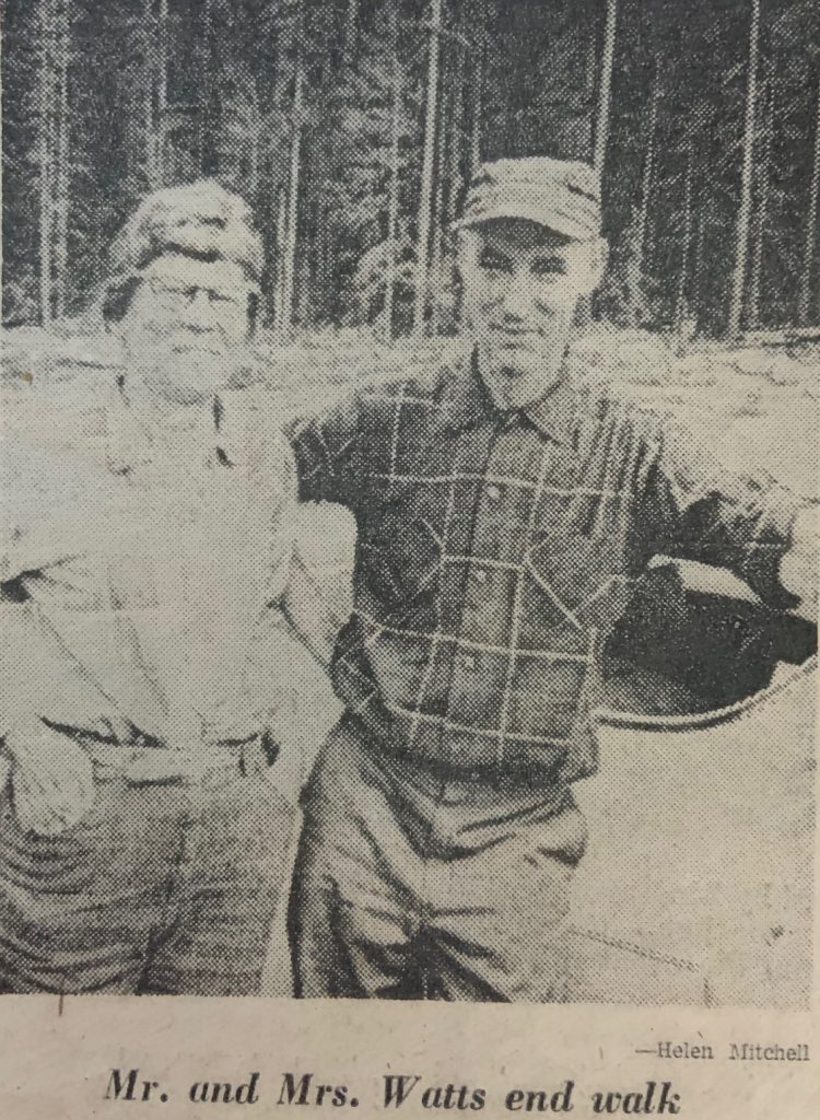
Mr. and Mrs. Watts end walk – Helen Mitchell photo.
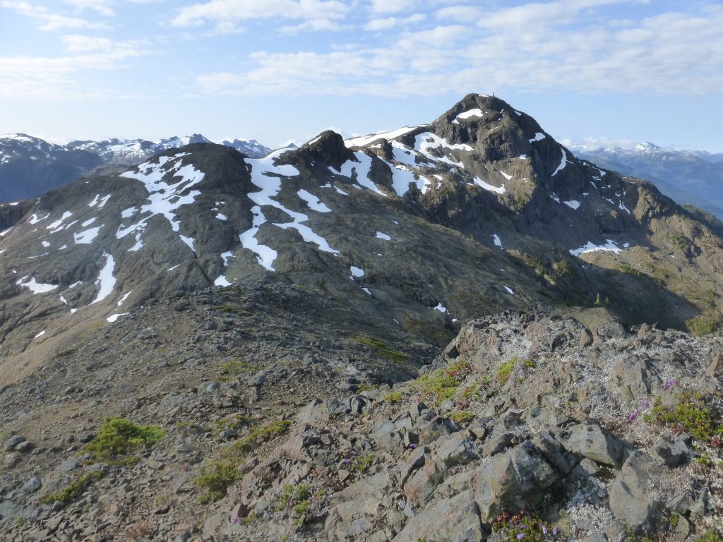
Mt. McBride from Marble Meadows 2015 – Lindsay Elms photo.
Marble Meadows looking towards Morrison Spire 2015 – Lindsay Elms photo.
Looking towards Morrison Spire and Limstone Cap from the summit of Mt. McBride 2015 – Lindsay Elms photo.
Mt. Arrowsmith: Protest Over Logging Follows Scenic Trail
Reported in The Daily Colonist Tuesday October 20, 1970. p.29.
By David Fleet
Parksville—The ever-changing face of protest managed to show its newest look Sunday, this time in the form of 150 hikers climbing a scenic mountain trail. The idea was to bring attention to what is seen as a threat to Mount Arrowsmith Trail. Those taking part said they were protesting proposed logging in the Pipeline Creek and Hanging Valley area, something they said would make it necessary to relocate the trail. The group—the Island Mountain Ramblers and B.C. Mountaineers—were led by Ralph Hutchinson of Nanaimo along a course that has remained unchanged for 60 years. The hiker has a choice of climbing to the summit of Arrowsmith, or following a fork trail to the peak of Mount Cokely. The Arrowsmith summit—longer of the routes—can be reached in six to eight hours. On Sunday the hikers set out from Cameron Lake, but some didn’t continue to the cold, high altitudes.
New Ski Centre Studied Near Ladysmith
Reported in The Victoria Daily Times Wednesday October 22, 1970. p.6.
Esquimalt MLA Herb Bruch said today he is hopeful that a skiing centre can be established at Coronation Mountain near Ladysmith about an hour and a half north of Victoria. Bruch said he is negotiating with Crown Zellerbach Ltd. which has a tree farm licence on the 4,200-foot mountain and has found the company “quite receptive” to the plan. A provincial parks branch study showed that Coronation Mountain and nearby Lookout Mountain, both about nine miles inland from Ladysmith, are the best sites for ski developments in the lower Island. The road to Coronation Mountain would be easier to travel and maintain in winter than the road to Green Mountain, another mid-Island ski centre. Bruch said the travel time to Coronation Mountain from Victoria would be about an hour less than to Green Mountain. Negotiations with the municipality of Ladysmith will also be carried out, Bruch said, because the community draws some water from the area. A proposed 1,600-acre recreation area would be established if plans work out.
1971
ACCVI Executive
Chairman – Syd Watts
Secretary/Treasurer – ??
Events:
May 22/23/24 – Ron Facer leads a trip to the southern peaks of Augerpoint Mountain [Syd Watts and Sid Williams Peaks]. Two parties – Mike Walsh and Tom Volkers, and Ralph Hutchinson and Ron Facer climb two different routes on Sid Williams Peak.
June 2 – Mike Walsh and Bill Perry make the 2nd ascent of Mt. Colonel Foster and a traverse.
June – Bill Perry, Ralph Hutchinson, Bryan Lee, Ron Facer and Roger Neave make an ascent of the Hourglass Route on Mt. Robson.
June – Bill Perry, Carl and Carolynn Lund, and Franz Bislin climb Mt. Assiniboine.
July 1 – Bryan Lee, Franz Bislin and Bill Perry climb Victoria Peak.
August – Ralph Hutchinson, Bob Tustin, Mike Walsh, Carl Lund and others climb in the Upper Tellot Glacier region near Mt Waddington.
August 7-14 – A party led by Syd Watts flies into Burman Lake for a week with ascents of the Golden Hinde and Mt. Burman.
December 1971-January 1972 – Rick Hudson and a team of South Africans (Paul and Janet Fatti, Michael Scott, Roger Fuggle, Tony and Judy Dick, Carl Fatti, and Paul Anderson—spent 50 days in the Paine National Park in Chile, resulting in first ascents of Espada (Sword) and Cuernos Norte (North Horn). They made a spirited attempt at the east face of the Central Tower of Paine before running out of time. (see R.D. Hoare. “The Sword and Cuernos Norte, Paine Mountains, Chile.” American Alpine Journal 1973, Vol. 18: pg. 300-332; Paul Fatti. “Cordillera del Paine. The 1971-72: Expedition to the Patagonian Andes.” MCSA Journal 1971, Vol. 74: pg. 3-17; Michael Scott. “Climbing the Sword.” MCSA Journal 1971, Vol. 74: pg. 18-20; and Michael Scott. “The Sword and others.” The Alpine Journal 1973, Vol. 77: pg. 195-200).
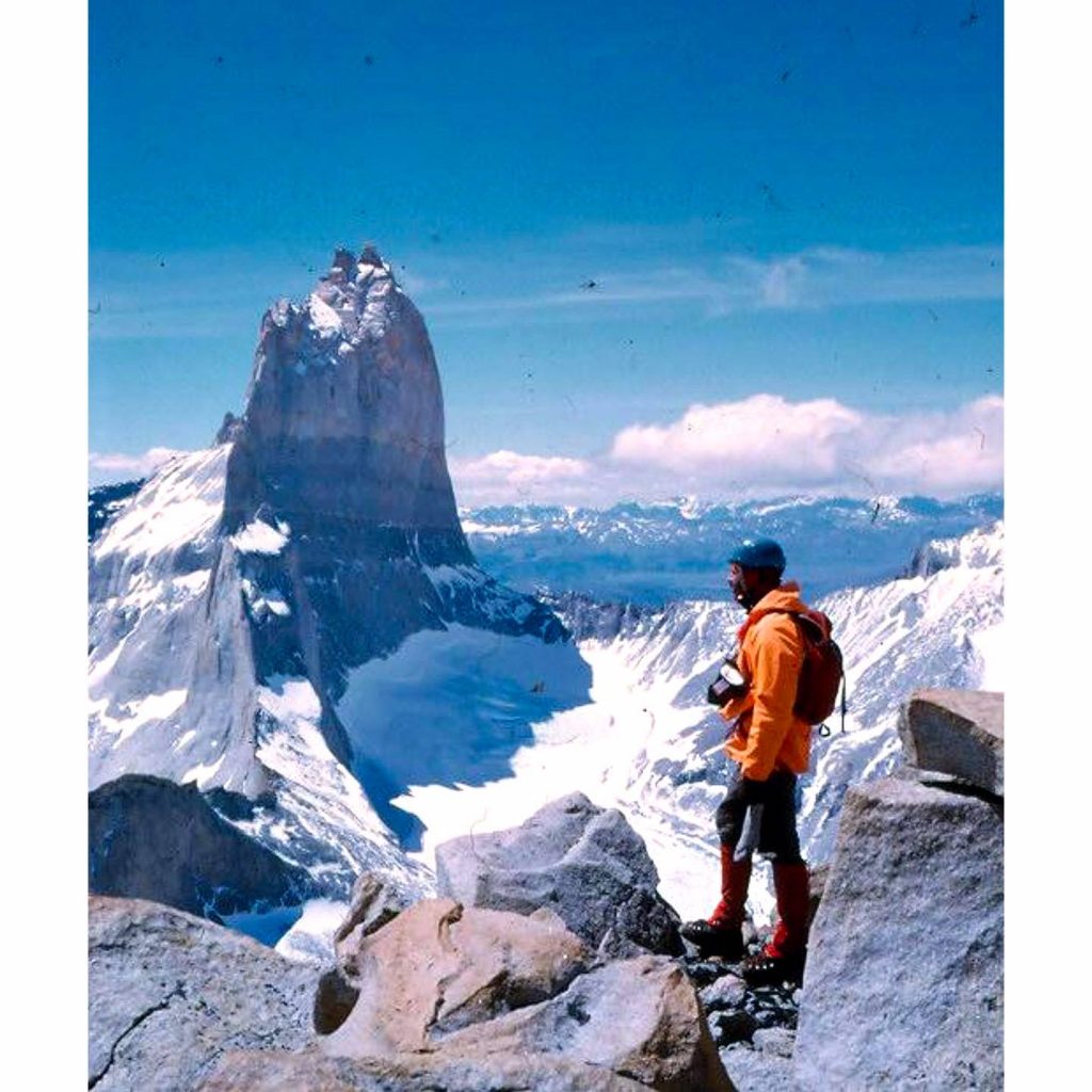
Paul Fatti on the summit of the Sword (Espada) December 19, 1971 – Michael Scott photo.
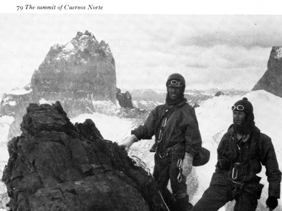
The summit of Cuernos Norte December 30, 1971 – Michael Scott photo.
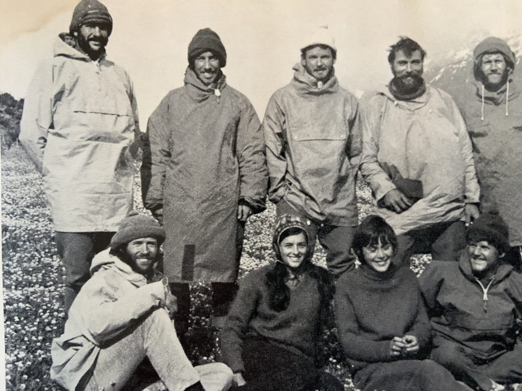
Members of the 1971/2 Expedition to Patagonia: Back row: Carl Fatti, Paul Anderson, Rick Hudson, Michael Scott, Roger Fuggle. Front row: Paul Fatti, Janet Fatti, Judy Dick, Tony Dick.
Work Starts on Faster Ski Route
New Road for Arrowsmith Area
Reported in The Daily Colonist Sunday February 21, 1971. p.25.
PORT ALBERNI—A road that will cut more than a dozen miles off the access route to Mount Arrowsmith ski area is under construction by MacMillan Bloedel. Work has started at the top of the Hump, the highest point on the Port Alberni Highway, where 1½ miles of road will connect with the Cameron Logging division main road. It will cut the distance to Rosseau Chalet to 11 miles. Access, currently by way of Port Alberni and out from the start of the Cameron division mainline, from the Hump is nearly 25 miles. The work is part of an eight-point commitment made to Port Alberni when the park area was turned over to the regional district for recreation. A second project on the highway near the Chalet access road, has MacMillan Bloedel workmen clearing and widening the trail to Loon Lake, a favorite summer fishing and winter skating spot. Parking facilities will be provided at Loon Lake, and clearing is also being done at the level crossing to provide better visibility for both car drivers and train engineers. A MacMillan Bloedel spokesman said the new ski access would make it much easier for skiers from the east side of the Vancouver Island to get to the area. However, the road will only be open on weekends and holidays, not during regular working hours, because of danger from logging trucks, blasting and falling trees. Access may also be limited by high fire hazard ratings in the summer.
Victoria Peak painting
In April 1971, an artist from Vancouver Island was commissioned by the Mayor of Victoria Courtney Haddock, to make a painting for the royal visit of Queen Elizabeth II on May 3 to Victoria. Local artist Lila Young had to move fast after receiving the commission. She did aerial surveys of the mountain she was asked to paint, making sketches at the same time after viewing it from every vantage point until deciding from which angle it would be best to paint. Whether it was intentional or coincidental, Lila was from the City of Victoria and the painting was of Victoria Peak, both of which are named after Queen Elizabeth’s Great-Grandmother Queen Victoria. The official unveiling of the painting was made at the Victoria City Hall on the morning of April 30 where an excited Lila showed off her creation. On Monday evening, Queen Elizabeth disembarked in the inner harbour from the HMY Brittania along with Prince Phillip, Princess Anne, and Pierre and Margaret Trudeau. The Queen made her way into Centennial Square where at a ceremony she was presented with the painting. Somewhere in the halls of Buckingham Palace hangs a painting of the third highest peak on Vancouver Island – Victoria Peak.
Gift Unveiled for Queen
Painting Idea Just Grew
Reported in The Daily Colonist Saturday May 1, 1971. p.22.
By Dorothy Wrotnowski
It was a quiet little ceremony at Victoria City Hall Friday morning that Mayor Courtney Haddock unveiled the painting that will be present to the Queen by the City of Victoria. Artist Lila Young was naturally more than a little excited. It was less than a month ago that Lila went to see the mayor about painting Christmas cards for the city when the idea of a picture for the Queen just seemed to grow. The oil painting is of Victoria Peak about 25 miles northwest of Campbell River. It is one of Vancouver Island’s highest peaks at 7,098 feet. Lila had to move fast after receiving the commission. She did aerial surveys of the mountain, making sketches at the same time. She viewed it from every vantage point until deciding from which angle it would be best to paint. The painting shows the snow-covered peak from a broadside angle looking both majestic and cold at the same time. The artist used a palette knife for the whole picture—her only use of brush was her own signature. Funnily enough, unbeknown to the artist herself until the painting was finished, she had painted a miniature of Queen Victoria onto the side of the mountain.
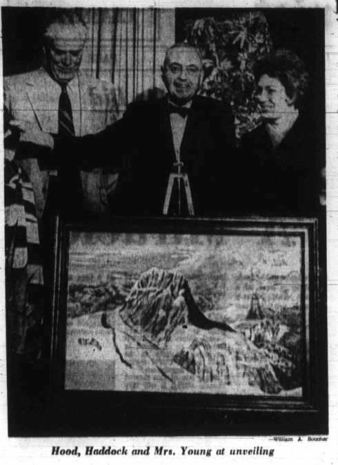
Hood, Haddock and Mrs. Young at unveiling. — William A. Boucher photo.
Augerpoint Mountain [Syd Watts and Sid Williams Peaks]
May 22-23, 1971
Reported in The Timberline Tales, newsletter of the Island Mountain Rambler, No. 7, Jan. 1972. p.5.
By Ron Facer
Seven of us started up Jack Shark’s trail [now known as the Augerpoint trail] which starts at the Buttle Lake road near Ralph River campsite. This being my first time on Jack’s trail, I really enjoyed it. The trail is well-marked with paint and ribbon. For most people this was the first back-pack of the season, so we all took a leisurely time making our way to our campsite, which is around 5000 feet. Some of us camped on snow and others were able to find places on some protruding rocks. The weather was excellent for the back-pack in and it fortunately held for the rest of the long weekend. The next day the party started out to the climb the two southern peaks of Augerpoint Mountain. Leaving camp at 7:30 a.m. the group followed the ridges and were on top of the first peak [Syd Watts Peak] at 10:30. This peak is a triangulation point. The final peak and most interesting of the two was climbed by two ropes. First, Mike Walsh and Tom Volkers did a direct route up the ridge from the col between the two peaks. This was a 500-foot class 4 climb of 75% very poor snow and 25% rock. Second, Ralph and I [Ron Facer] dropped down from the col to the right of the peak and circled around to the middle of the peak. Here we did a 500-foot class 3 rock route on excellent rock which was broken and solid. The excellent rock downgraded a few spots of class 4 to class 3. The two parties met at the same time at a small crack near the top, which was a coincidence. Both parties were on top by 12:30. After a brief stay on the top, the two ropes descended by a gully which starts at the top of an overhanging lower peak, which is about 100-foot lower and to the south of the peak we climbed. We then returned by the way Ralph and I came down from the col. After returning to the main camp, the group decided to go down to the cars, because the weather didn’t look too promising. The descent took two hours.
Participants: Mike Walsh, Ron Facer, Bob Tustin, Ralph Hutchinson, Tom Volkers, John and Doreen Cowlin, Ted Waugh.
Syd Watts Peak 2015 – Lindsay Elms photo.
Sid Williams Peak 2015 – Lindsay Elms photo.
Burman Lake Trip
August 7-14, 1971
Reported in The Timberline Tales, newsletter of the Island Mountain Rambler, No. 7, Jan. 1972. p.9/10.
By Emily Watts
Saturday: Flew to Burman Lake. A hot sunny day. Syd pointed out the route up the face of Mount McBride climbed by the Alpine Club in the summer of 1970. Hiked up to 5000-foot shoulder of the Golden Hinde for views.
Monday: Climbs of the Golden Hinde using the regular and John Gibson’s route. Much more snow than usual in August but it was going fast. Saw some birds as on my previous Golden Hinde climb [1969]. Best guess: Rosy Finches. No confirmation: few mountaineers interested in Rosy Finches.
Tuesday: Another magnificent day. Climbed Mount Burman, Don Apps and Syd retracing their route and reminiscing over a previous 1961 trip in which they got caught in a rainfall of 8” in 6 hours. Returned by way of lake shore, scouting an easy route for a possible trail to a better camp area at the small lakes below Mount Burman which is on the through route, Marble meadows to Elk River.
Wednesday: Pary separated, one to explore the lakes to the west of the Golden Hinde, one to climb Mount DeVoe and then to move back to attempt the west ridge of the Golden Hinde. The lake group saw an unspoiled area of pastoral beauty. We would hope in the near future that steps be taken to have this area scouted out as a possible ecological reserve, to preserve its fragile beauty. The DeVoe group changed plans, camped at a big rock slide and planned to climb the west peak [The Behinde] of the Golden Hinde from there.
Thursday: Lake group packed onto Mount DeVoe ridge. Had much needed baths and did laundry. Slept under the stars and woke in the early dawn to see the long fingers of an approaching storm.
Friday: Rose to an indefinite sky and hiked over the ridges to Mount DeVoe and a splendid view of the Golden Hinde. Speculated as to where Alan’s party were on the Hinde. Unknown to us a slip on a rock had given him a scalp laceration resulting in a decision to postpone the west Hinde ascent. The swift approach of the storm brought realisation that to complete our DeVoe climb would result in our being caught on the ridge in a storm. Reluctantly we returned to camp, packed hastily (15 minutes, and beat a hasty retreat to Burman Lake.
Saturday: Quiet day spent in tents and under shelter in fog and rain. Had time to note the amazing number and variety of alpine plants on the shoreline, including a dwarf Red Spirea.
Sunday: Morning brought clearing weather, and complete with garbage we flew out to Campbell River. Poor weather cancelled part of the group’s planned hike out over Marble Meadows.
A glorious week spent mostly under blazing sun. Perhaps more climbing could have been done but next year always comes.
Participants: Syd and Emily Watts, Don and Sylvia Apps, Alan Robinson, Richard Millar, Keith Waterfalls.
Consultants To Study Sports Site
Reported in The Victoria Daily Times Tuesday August 10, 1971. p.17.
A consulting engineering company has been hired to study two alternative sites for a proposed major winter sports centre on southern Vancouver Island. The merits of further development of the Green Mountain ski centre near Nanaimo will be studied along with a proposed new development at Lookout Mountain east of Ladysmith. F.F. Slaney and Company Ltd., of Vancouver has been hired to complete the study this year said Herb Bruch, Social Credit MLA for Esquimalt. Bruch said he hopes work will get under way on a major centre for skiing and other winter sports next year. The consultant’s report would include estimates on usage of each site and a design for basic facilities at the most suitable site. Bruch said Lookout Mountain has been the subject of a provincial recreation department study. The site would be about an hour closer to Victoria by car than Green Mountain.
Mt. Colonel Foster
Reported in the Canadian Alpine Journal Vol. 55, 1972. p.55/56.
By Mike Walsh
Mount Colonel Foster is a series of six steps, narrow rock peaks cirqued above a tiny glacier, at the head of a pocket valley off the upper Elk River in Strathcona Provincial Park. It has long been the subject of conversation amongst mountaineers on Vancouver Island and has, in the last few years, become the object of attack by the more ambitious. The first ascent of any of the peaks came during the Provincial Government surveys of 1935-36, when two surveyors [Alf Slocomb and Jack Horbury] bent on mountaineering let their wanderlust lead them up the rotten east gully to the summit of the southeast peak on an unofficial sortie. The surveyors took no instruments with them, and, in fact, the highest station occupied by the survey party on Colonel Foster was over 900 feet below the summits. The same route was repeated in 1954 by a small party of the Victoria section of the Alpine Club of Canada [Syd Watts, Pat Guilbride, Bill and Mallory Lash]. The third ascent of the mountain was in 1957, when Ferris and Hugh Neave and Karl Ricker fought their way up the very rotten western gully to the southwest peak, to be rewarded with an internal view of a heavy overcast. Their article (CAJ. 1958, p.35) led readers to believe the party had climbed the highest peak, but my observations from the southwest peak in 1971, and the peak immediately north of it in 1968 and 1971, showed the latter peak to be the highest summit of the mountain. This is borne out by sheets 92F12W and 92F13W of the Provincial Government Topographical Series. The next ascent was accomplished in 1966 by Ralph Hutchinson, Ron Facer and Mike Hanry. They traversed the southeast peak from the east and climbed the southwest peak (CAJ 1967, p.55). On the summit they found the 1957 Neave-Ricker cairn and summit note, which thus robbed them of the first ascent they had expected. To the north stood the highest central summit and no cairn could be seen on its top. An unsuccessful attempt was made to reach the higher peak before rejoining the remainder of the Island Mountain Rambler party on the southeast summit. A reconnaissance and further attempts were mounted on the main summit during the following week, but without success. July 1968 saw the next success on the mountain. I had bushwhacked up Butterwort Creek from the Elk River valley to carry out a solo reconnaissance of the mountain from the north. The trip proved so successful that it took me to the summits of the four virgin peaks. (1968 Timberline Tales – the newspaper of the Vancouver Island Mountain Ramblers.) I attempted at that time to continue to the southwest peak, but time and weather combined with Class 5 rock to turn me back and down a gully to the west. In 1969 Blair Paterson, Steve Weber and I made the second ascent of the northwest peak in a north-south traverse. Now I had heard of Bill Perry and he had heard of me, but we had met only once, rather fleetingly, and we had never climbed together. We both had the idea of a complete traverse of Mount Colonel Foster’s six peaks brewing in our separate minds, and with a long weekend fast approaching, we were both trying to find a partner for the climb. On 27th June there was a club day trip to Mount Arrowsmith, the last chance for me to find a partner for Colonel Foster. Bill had had the same idea. We met and on the summit of Arrowsmith made plans for the July 1st weekend. We both managed to get a four-day weekend, a necessity for the proposed traverse, and found ourselves bedding down beside the car at the start of the Elk Valley shortly past midnight on Wednesday. Thursday dawned through a light drizzle, and forsaking an early start, we waited for drier weather over a lengthy breakfast. Two hours up the elk trails in the valley took us to the junction of the Elk River and Butterwort Creek. After a short lunch stop, we commenced our fight up the Butterwort. And what a battle it was! Very dense and steep traversing through salal and slide alder, and over and under an infinite variety of windfall and snag, put us on a very greasy traverse of steep slab, with the first bounce destined for the creek bed a few hundred feet below. Three more hours of bushwacking and slogging took us in an ascending traverse to an open snow slope below the north shoulder of the mountain. Another rest and then the final push to the top of the shoulder to a tent pitched in the setting sun. A light meal and a mindful of anticipation put us to sleep at a late hour. Friday morning came very quickly, and sunrise saw us front-pointing up a snow gully on the north peak. We changed out of crampons and into an iced-up gully–wasted time; out onto a verglassed last wall–more wasted time. A hasty decision and a short retreat had us front-pointing a traverse into the gully between the north and northwest peaks.
Up the gully we climbed; to kicked steps, to mid-thigh slop at the top of the col. We had bypassed the north peak in a time saving move prompted by frozen fingers in an early morning northwest chimney. One peak down, but none climbed – not a very auspicious start. A tense moment and some swearing took us across a rotten moat lip onto unstable snow on the northwest peak. Another lead and we were on rock moving quickly enough to warm our bodies and our spirits. Minor route-finding problems and some scrambling sank the north peak below us putting us on the knife-edged summit ridge, along which we performed a high wire act to the summit for a yodel and a fresh rock on the cairn. A 500-foot plunge put us in the next col, and at the base of the thrust of the northeast peak. A small bulge then some Class 4 and another bulge, put us on easier ground and led us up the 700 feet to the summit. During lunch on the northeast peak, we spotted two climbers (Ron Facer and John Goldrup) on the east face of the north peak and several tents (of what turned out to be a BCMC trip) 4000 feet below us, by the lake at the base of the east wall. I scrambled down into the next col and some easy Class 3-4 put us on the main summit in the late afternoon. We relaxed there for a while under cloudless skies and watched the climbers on the north peak. Having added to the cairn, we moved on down the ridge to find a bivouac site. About 300 feet below the summit, we found a flat-topped rock thrust out of the rest side of the ridge. It was just large enough to accommodate my one and a half man tent, with rocks tied to the guys and dangling in the void, acting as pegs. Saturday morning sun found us scurrying to get packed and on our way. The ridge led down for 100 yards, then dropped in a tricky bit of Class 5 traversing around the base of a gendarme, then some Class 4 into the col. A slab with a good bong crack led us onto a knife-edge where the going became easier. A rotten little gully took us down to a rock island in the snowfield to the north of the southwest peak. After a hasty lunch on the island, we slopped knee deep across the snowfield towards the moat as clouds rolled in from the west. A nasty pitch, protected by two tied off pitons, took us across the moat and onto a rotten rib. A 135-foot lead on a 130-foot rope topped the rib and put us on some relaxing Class 4, which lasted the remaining two leads to the summit ridge. A short scramble then had us on the cloud-enshrouded southwest summit at 7 p.m. After a hurried rest we climbed down into the last col and balanced across its fantastic blocks to the southeast peak’s little problems. Some grovelling and cursing helped us top the layback and chimney, and put us on the summit of the last peak at 9 p.m. We threw a rock at the cairn on our way to the gully. A scramble over loose blocks and down a rotten face led us to fresh footprints in the snow and a 1000-foot glissade down the east gully to the east shoulder. 2000 feet of glissade – scramble – glissade took us to the glacier and our dash across it to the lake. The traverse around the lakes edge took an eternity in the race to beat the end of the twilight to the end of the lake. Darkness won out, but only by a few minutes and several stumbles over logs. A hot tea was forced on us by the occupants of the tent we had seen the previous day from the peaks. They climbed the southeast peak, but their attempt on the north peak had failed just short of the top. An 11 a.m. start on Sunday took us down the elk valley in a leisurely four hours to a cold bath in the river. Some fantastic new routes remain to be done on Colonel Foster. The entire mile long 3500 feet high east face is virgin. There has been only one visitor to the summit of the north peak and two on the northeast and main summits of this, the fourth highest and the most difficult mountain on Vancouver Island. Of course, there is still the full traverse of the six peaks waiting to be done – maybe next time we’ll get them all.
Foster Flashes
Reported in the Canadian Alpine Journal Vol. 55, 1972. p.56.
By Bill Perry
1 July. Sundown. Camped on the shoulder beneath the north peak. Snow flurries and numb fingers. One moment sombre views of Elkhorn and Rambler-the next, we’re shrouded in mist. Determination and apprehension: Gotta make this baby go. Been raining all month-we’re geared for bad weather, so let’s give her all we got. Still, I’m sure hoping the mountain won’t all be like that horrendous traverse above Butterwort Creek.
2 July. 3 a.m. awake to still clear night. Bright, star strewn sky forecasting at least one day of good weather. Back to sleep. Crisp clear dawn. Cramponing the gully, then at last onto the northwest summit ridge- the jagged backbone of the mountain we’d follow for two whole days. “What’ll we call the traverse now?” “How about the full traverse of the five major peaks of Colonel Foster?” Trouble the north peak (lowest by 200 feet) looks highest from the usual campsite to the east. All day unroped but 2 pitches on the northeast peak. Keep mainly to the right of the ridge when it’s too steep to follow. If the going gets too thin, try the left. Descents and bypasses usually by loose-looking gullies which drop steeply a few 100 feet and disappear into sheer nothing-these the only parts I found on pleasant. Otherwise, good climbing, sound rock and perfect weather. Ropes would have created more problems than they’d have solved, as the gullies were devoid of cracks and natural anchors. But then I might not have had falling fantasies while going to sleep that night. my most airily aesthetic high camp ever. Atop the ridge and ringed by the white peaks. Whole ranges visible to the west even in starlight. Then, to my surprise, a sleep full of pleasant dreams and peace and quiet breathing.
3 July. Roped up for the direct descent to the gendarme and around it on an unlikely-looking traverse to the right (west). Then top the ridge and down the other (east) side of it to a snowfield. It took all morning. Could be we (I) overprotected in places, but it was early morning on steep pitches never climbed before. And, man, the exposure! Now the push to the southwest peak. We’d expected the greatest difficulties here. Getting started was a bit of a puzzle, but then pleasant climbing-some delicate moves, but nowhere near the sustained high angle stuff we’d anticipated. Snow, three rock leads, a mixed snow-rock pitch and the scrambled to the top. As usual, we alternated leads. We’d psyched ourselves up for this in a really positive way. I felt a kind of electricity flow along the rope as we shared the pure animal joy of climbing. The next bit to the southeast peak was anticlimactic. We got off route once and missed the full appreciation of the final knife-edge traverse. In the fog we could only imagine the 3000 foot drop on either side. A tight chimney forced us to haul our 40-pound packs up a short pitch to the final summit-the only time this was necessary during the entire traverse. Then we “traced the little footsteps in the snow” all the way to Foster Lake and the BCMC camp. To (yes!) handshakes, tea, and questions from wide-eyed girls. Flat ground, people, a warm and welcome fire. A perfect end to a climb and more reminiscent of the Alps than wild Strathcona.
Climbing Report: Vancouver Island
Reported in The Canadian Alpine Journal Vol. 55, 1972. p.69.
By Bill Perry
1971 was an average year for climbing on Vancouver Island, according to those who have been here long enough to make such comparisons. By approximately doubling the number of hikes and climbs on the Island Mountain Ramblers’ schedule, the quality of these organized trips was also improved by reducing the number of people per trip. The island’s three highest peaks were climbed – possibly the first time all three were done in the same year. The Golden Hinde was climbed by the “normal” route and the one pioneered by John Gibson in 1970 during the trip to Burman Lake, 7-14 August, led by Syd Watts. Mount Burman was also climbed during this and an attempt on Mount DeVoe foiled by storm. Elkhorn Mountain was climbed by a BCMC party from a campsite near Foster Lake on 1 July while climbs on Colonel Foster were in progress. Victoria Peak was climbed over Thanksgiving, a three-day weekend, without the use of aircraft. thanks to a new logging road. The mountain is now accessible from the north. Bryan Lee, Franz Bislin and I [Bill Perry] crossed the White River, followed the creek between Queens Peak and the Victoria-Warden massif and arrived at the campsite on the southeast shoulder by evening of the first day. From here we gained the summit via an established route on the east spur. I believe this approach was explored previously by Richard Miller. An exhilarating traverse of Mount Colonel Foster, including a previously untried section of the summit ridge is covered in a separate article by Mike Walsh. Three new approaches to Mt. Arrowsmith are worth noting.
- East Gully: Leave M&B’s Cameron Division’s Pass Road at a bridge 1 ¼ mile before reaching the Rosseau Chalet. Following a spur road to the right (north), cross a creek and ascend gully east to the Cokely-Arrowsmith col and thence by normal route. Done 27 June by Ralph Hutchinson and Ramblers party. 4 ½ hours car to summit.
- South Direct: leave pass Rd. at any convenient point below the south face of Arrowsmith. Ascend by the most direct route to the main summit in 2 ½ hours. Source of information: Ron Facer.
- Blacky’s Route: Follow M&B North West Bay Division Main road along Englishman’s River as far as possible. Finally, road 143A40 crosses the river (now just a creek) and climbs steeply north east. Leave car at creek and follow creek and its main gully above to a small lake just below the south west of the Cokely-Arrowsmith col. Proceed to col or climb one of the gullies on the east face of the summit ridge. Car to summit: five hours. Approaches 1 and 3 are bushy; most pleasant in deep spring snow.
On 8 and 9 August Mike Walsh and Bob Tustin established a new route on the north ridge of King’s Peak in Strathcona Park. Grade 2 to 3 and worth repeating. There were several other climbs in the Strathcona worth mentioning: On 23 May, the south west peak of Augerpoint [Sid Williams Peak] was climbed by two parties. Ron Facer and Ralph Hutchinson established a new route on the north west face while Mike Walsh and Tom Volkers duplicated the north east ridge route of the first ascent party (Carl Lund and Brian Foan, October 1970). Both roots were Class 3 to 4 and descent was via a south gully. In August, 1971, Carl Lund and Brian Foan ascended Mount Mitchell from the south. This was a ridge and face effort, mostly Class 4, and the first time the peak has been approached from this direction. A party of 11, led by Syd Watts, explored the seldom visited Ash River Valley, the southern entrance of Strathcona Park, on the weekend of 12 and 13 June. An enjoyable day of rambling by foot and canoe was followed by a hike up the ridge east of Oshinow Lake, with views of Mount Septimus, The Red Pillar and Flower Ridge. Two up island ventures were conducted by the ACC Vancouver Island section. On 2 to 4 September, a reconnaissance of Pinder Peak (5060’) was driven back by rain at the 3200’ level. Pinder is located between Tahsis Inlet and the Nimpkish valley. Party members John Gibson, Roger Neave and Alan Robinson feel that this fine looking, twin-peaked mountain is well worth revisiting. On 9 to 11 October, Syd Watts, Jack Clark and John Gibson returned north; this time to the Schoen Lake area. They reached the west summit of Mount Cain (5920’) as well as climbing an unnamed peak connect connected to Cain by a long ridge. This peak, they called Mount Abel. The impressive and apparently unclimbed east summit of Mount Cain, they feel, would certainly justify another trip to this infrequently climbed area. Rock schools were held for the first time this year by the IMR. The two sessions at Piper’s Lagoon and one on Mount DeCosmos, in April and May, attracted about 20 people per trip. Meanwhile, the Victoria Outdoor Club held rock climbing instruction and a snow and ice school on Mount Baker. Rock climbing practice cliffs were discovered near the top of Mount Moriarty, on Parksville’s Little Mountain, and on the north side of Cameron Lake. These are all in central Vancouver Island and easily accessible. Ten short routes, Class 4 and up, have been established, and a few have pitons left in place.
Schoen Lake Area
By John Gibson
Syd Watts, Jack Clark and John Gibson arrived at the Schoen Lake turn in the Nimpkish valley about 2:30 p.m. on 9 October. We started towards Schoen Lake, but seeing a logging road named Mount Cain, which appeared to lead close to timberline on the south ridge of Mount Cain, we turned off. The logging road came up to expectations and soon we were at 3700 feet, in the sub-alpine zone. From the end of the road, we walked up a pleasant ridge and emerged above timber in less than an hour, onto the summit ridge of Mount Cain (5920’). An easy scramble soon had us on the west summit, presumably the one marked 5920 feet, and from there we could see the east summit, an impressive looking tower beyond an impressive looking gap, might well be the higher of the two, and would certainly be the more interesting one to climb. We assumed that it had not been climbed, for there was no sign of a cairn on it. It was now after 5:30 p.m., and if we were to get back to the car by dark, there was no time for dalliance with unclimbed towers, so temptation was resisted and we retraced our steps, camping at the delectable spot at the top of the road. So far, the weather had been fine, though smokey from slash fires, and we planned to spend the next day traversing the ridge from Mount Cain to an unnamed peak at the other end of a cirque, which obviously ought to be Mount Abel. But in the morning, we were enveloped in mist, and the weather showed all signs of breaking. We walked around the corrie between and drove down our logging road to a fork with another, which took us up to 3900 feet on Mount Abel. The weather was now improving, the mist was relatively dry and it periodically cleared giving us fine glimpses of ridges and little lakes towards Mount Schoen to the southeast, and occasional views of the Rugged Range across the Nimpkish valley. Again, a pleasant walk soon had us above timber and on the summit of Mount Abel, which would have been the last point on our ridge traverse, had followed the cirque round from Mount Cain. We sat on the summit waiting for the mist to clear between us and Mount Cain, so we could have a good look at the interesting east summit from another angle. But the mist would not oblige and our curiosity was not satisfied. We carried on down to the car and down the valley, and camped beside Schoen Lake. From here Mount Schoen (6109’) illuminated by the setting sun and almost free of clouds, persists in memory and invites return.
Pindar Peak Reconnaissance
By John Gibson
A small party consisting of Roger Neave, Alan Robinson and myself set out on Thursday 3 September for Pinder Peak, situated on the watershed between Tahsis Inlet and the Nimpkish valley. We hope to reconnoitre the approaches to the mountain on the Friday, and climb during the weekend. Though only 5060’ high, Pinder is a fine looking twin peaked mountain, and a conspicuous landmark from the West Coast between Kyuquot Sound and Cape Cook. It is also visible from Johnstone Strait, and ought to be a particularly good viewpoint. We had a magnificent view of our mountain by the light of the full moon, as we approached Atluck Lake at about 1 a.m. on the Friday morning – and that was the last we saw of it. We camped at the north end of Atluck Lake, and in the morning the clouds were down to 1000 feet or so. We drove along the logging road beside Atluck Lake until opposite two islands about halfway down the lake, then put our boat in the water and rode across the lake to the base of a prominent rock slide on the slopes of Pinder. We started up the slide, which is old and moss covered, and offers quite good going. Higher up it got bushier, and the rain intensified, and the bush got wetter. We reached a bump on the ridge at 3200’, from which we could see the next part of the ridge and the natural route, changing from forest to alpine in nature, and leading up into swirling mist. We had come through the lower layer of cloud, and we’re now between layers, where it merely poured with rain! Honor was satisfied, and we retreated, saturated. Our camp was saturated too: I think it rained 1 1/2 inches that night. Alan slept in his car, Roger and I in my tent, which leaked. Roger gallantly arranged a plastic over the top while I snored within. In the morning the barometer was lower than ever and still falling. We cooked our breakfast in a derelict washroom which was conveniently available, then broke camp and went home to get dry. Although frustrated by the weather this time, we certainly want to go back. Canadian Forest Products, in whose logging area this mountain stands, we’re particularly helpful and co-operative, obtaining a campfire permit and delivering it to our tent, and offering to ferry us across the lake. From a camp in this area, one should also be able to get at the north end of the Rugged Mountain Range, from the road which goes through to Zeballos.
1972
ACCVI Executive:
Chair – Syd Watts
Secretary/Treasurer – ??
Events:
June – Rick Hudson attempted the south ridge of Huayna Potosi (6088m) in Bolivia.
June 17 – Rick Hudson and Alan Waterman (USA) climb Illampu (6368m) the fourth highest mountain in Bolivia. (see R.D. Hoare. “The Big Little Expedition. Climbing in the Cordillera Real, South America.” MCSA Journal, 1973. Vol. 76: pg. 30-36.)
?? – John Gibsons leads a traverse of Mt. Landale and El Capitan Mtn.
May 13 – Syd Watts leads an ACCVI trip to Mt. Arrowsmith.
June 11 – John Gibsons leads a trip up Mt. Arrowsmith.
June 25 – ACCVI trip to Mt. Adrian led by Syd Watts.
July – Bill Perry and Mike Walsh make 1st ascents of Shadowblade in the Mackenzie Range.
July 15/16 – Bill Perry, Ralph Hutchinson, Joe Bajan and Ron Facer climb the North Tower of Mt. Colonel Foster.
August 12-20 – Syd Watts leads an ACCVI trip of 15 people to Bedwell Lake. Big Interior Mtn. and Mt. Tom Taylor are climbed.
Sept 2/3/4/5 – Dick Culbert, Fred Douglas and Paul Starr climb the east face of Mt. Colonel Foster.
September 2/3/4 – Bill Perry and Franz Bislin climb Warden (2nd ascent) and Victoria Peak.
September 2/3/4 – Don Apps leads 39 people to the summit of the Comox Glacier.
September 17 – Bill Perry leads a trip to Mt. Moriarty.
October – ACCVI trip to the Elk valley. Elkhorn Mtn. and Elkhorn South are climbed.
December 15 – The Annual General Meeting held at the Ingraham Hotel. Slides of the Fryatt camp were shown.
The Augerpoint Trail
One of the last days of July 1971, Bill Lash and I [John Gibson] hiked up Augerpoint, using Jack Shark’s trail, and were really impressed by the excellent job he has done, on his own initiative and without subsidy. I thought the story of how he came to make this trail would be of interest, so I asked him for a write-up on it. He kindly complied, and here it is.
Reported in The Timberline Tales, the newsletter of the Island Mountain Ramblers, No. 8, Jan. 1973. p.2/3.
By Jack Shark
I made the trip across from Buttle lake to Courtenay and also the other way several times, and every time I went I tried out a different route, but always got into the same fix. There was a belt of salal and devil’s club mixed with windfalls all along the road at Buttle Lake, and there were cliffs just before on got on top of the ridge at the 5000’ level. There did not seem any way around these obstacles. A couple of years ago I took Syd and Emily Watts across from Courtenay and as we descended the cliffs toward Buttle Lake we noticed a rocky ridge going down part-way and running parallel with the top ridge. We did not have time to investigate further, but I fixed the position in my mind. The following spring with the help of Nial Forster and his son Brian, we scouted out an approach from the road that would lead us to the bottom of the ridge. It took three tries to find one place where there was no mess to go through, right from the road. We found enough deer trails which could be linked up to form a tentative route to the ridge, and that is the route which is marked with paint on the trees. Once I had established the direction of the trail I started to put in switchbacks at the worst spots and as time progressed, I gradually linked them together to make the trail as it is now. I had several small unofficial workparties to help me last year. Apart from that I’ve been at it off and on for nearly three years now, and hope to get most of it finished this fall (this was written August 1972). You may have noticed that no work was done at the bottom of the trail. I left that intentionally unfinished to discourage the type of person who just goes up a little way to see what it is all about and usually leaves a lot of litter behind. The rope at the low cliff was donated by Bryan Lee, who bought the discarded ski tow rope from the Mount Becher ski area and donated it to the Comox District Mountaineering Club. I hope to use some of that to advantage for bridging some of the creeks on various trails. As far as the Parks Branch is concerned, it is just another deer trail with maybe a little involvement from me and several others who are interested in making things a little easier for climbers to get into the mountains. After all, they had the Park for sixty years now, and how many trails did they build? I for one have no intention to wait for holy bureaucracy to sort itself out and give me their blessings. When I want something done, I find the best way is to do it yourself. If at the same time, somebody else can get some benefit out of my misbehaviour, so much the better. I did not want to publicise what I was doing because I thought the fewer people were involved, the less repercussions there would be, if any. In the meantime, the trail is there to be used, and that is what counts as far as I am concerned.
Island Skiing Conditions Good
Reported in The Daily Colonist Friday March 3, 1972. p.12.
With new snow falls in both areas, conditions are again good for skiing this weekend at Green Mountain and Forbidden Plateau. There is a foot of new snow at Green Mountain, where the temperature was in the 20s under overcast skies Thursday. The access road was in good condition Thursday but chains are mandatory. Lifts will be open from 9:30 a.m. to 4 p.m. Saturday and Sunday. At Forbidden Plateau, there are eight inches of new snow on a 94-inch base and temperatures were around 24 degrees Thursday. The tows will be closed today but will be open Saturday through Wednesday.
Coronation Mountain Lacks Snow
Reported in The Daily Colonist Friday March 3, 1972. p.21.
NANAIMO – MLA Frank Ney of Nanaimo said he has received information that there is not enough snow on Coronation Mountain where the provincial government is considering lending a financial hand for the development of a major ski area. Ney was referring to a letter from Port Alberni lawyer Bill Beckingham, who is acting for the Mount Arrowsmith Ski Club. Beckingham said: “We are told that there have been periods within the last quarter century of approximately five consecutive years when this mountain has not had quite enough snow for skiing.” If this is the case, Ney has told Recreation Minister Kenneth Kiernan, the provincial government should reconsider developing Green Mountain near Nanaimo as a provincial park. At least, the government could have a proper access road completed so that Green Mountain can be used by all lower Vancouver Island skiers, Ney said. “I would point out that Green Mountain is already fairly well developed with skiing facilities and the cost to the government would probably be substantially less if they decided to develop it.” Beckingham said a survey made by the Alberni-Clayoquot Regional Board indicates that the Mount Arrowsmith, Mount Cokely area would be much superior to either Coronation Mountain, Green Mountain or Forbidden Plateau as the area would provide adequate facilities for beginners, intermediates and senior skiers. Coronation Mountain could only be regarded as a beginning area, he said. Mount Arrowsmith and Mount Cokely would provide a five-month skiing period, and being in the centre of the island, are more accessible to more Island centres.
Island Skiing Scheme B.C. Ready to Build
Reported in The Daily Colonist Friday March 10, 1972. p.21.
The B.C. recreation department will probably begin work on a government ski development in the Lookout-Coronation Mountain area near Ladysmith shortly after April 1, Recreation Minister William Kiernan said Thursday. Mr. Kiernan said that he expected work would begin on a road into the mountains which are to be developed “shortly after April 1.” Coronation Mountain is about seven miles west of Ladysmith. The government had decided to go ahead with the project after it examined results of a study made by Slaney Recreational Consultants which recommended the development he said. The study showed that there would be “a very substantial demand” if a resort was built near Ladysmith because it was so near large centres of population on the Island, particularly Greater Victoria. Although snow conditions there “were not the best on the Island,” they were adequate, and when all factors were taken into consideration, the firm felt this was the best place for a first provincially-sponsored ski development on the Island. The firm had also studied the Green Mountain area near Nanaimo, the minister said, and had concluded that while development should not be started there immediately, the government should keep its options open there. In the future green Mountain would make a likely spot for “a more top-flight sort of development” as far as skiing conditions were concerned.
Snow Birds Back Lookout Plan
Reported in The Daily Colonist Friday March 24, 1972. p.21.
NANAIMO–The Sno Birds Lift Society – the organization that operates the Green Mountain Ski Hill – has come out in support of the provincial governments decision to develop Lookout Mountain near Ladysmith as a ski area. A spokesman for the organization said the development will hurt Green Mountain in the short run, but will help skiing all over the Island in the long run. Sno Birds executive said they agreed that it was important for the government to develop a ski hill at Lookout Mountain because it is close to the large centre of population on Vancouver Island. The hill is ideal for beginners and intermediate skiers, they said, and eventually these people will progress to the more demanding slopes of Green Mountain. The spokesperson said it is important for people to realize that it is Lookout and not Coronation Mountain that will be developed. Coronation Mountain does not have adequate snow whereas Lookout does. The club said the Island can support at least four major ski areas: Lookout, Green, Mount Arrowsmith and Forbidden Plateau.
Traverse of El Capitan and Landale
Reported in The Timberline Tales, the newsletter of the Island Mountain Ramblers, No. 8, Jan. 1973. p.7.
By John Gibson
We parked almost in the pass between Mount Whymper and El Capitan Mountain and left the road where it crosses the creek a little bit south of the pass. We angled up to our right through big trees heading towards El Capitan. Nice going, and it is sad to think those big trees are probably doomed. Soon we emerged onto open snow-covered terrain, the logging scars all nicely hidden by the snow, and continued to angle up, on good snow, to reach the main ridge at the col and nearest to El Capitan. Here we turned right and were on top of El Capitan soon after noon. We sat, ate, admired the view, and watched the mighty army of Ramblers appear on the summit of Mount Landalt [Landale]. At 1 p.m., we started down and along the ridge to Landalt, over the first bump, then down some steep snow to the right, and back up again, to evade the next one; up onto the ridge beyond it, over the last bump and up the final snow slope to Landalt (2 p.m.), where the rest of the party was still assembled. We left the summit at 2:45 and had a lovely glissade down the snow slopes on the east side, into a hanging valley where we crossed the tracks of quite a large avalanche, with a lot of broken yellow cedars. We traversed out of the valley to our left, onto a well-defined ridge, down it for a bit, then off again down steep snow into the next gully on the left, also full of old avalanche and broken trees. We crossed the creek on a snow bridge near the bottom of the gully and only left the snow when we got into the big trees two or three hundred yards above the cars, which we reached soon after 4 p.m. A very pleasant route altogether, and we were back through the gate punctually by 5 p.m.
Mount Colonel Foster, North Peak
July 15/16, 1972
Reported in The Timberline Tales, the newsletter of the Island Mountain Ramblers, No. 8, Jan. 1973. p.8/9.
By Bill Perry
On the morning of 15 July, we started off early under cloudless skies up the Elk River valley. Ralph Hutchinson, Joe Bajan, Ron Facer and I [Bill Perry] intended to camp near the 5000’ level on Foster’s north shoulder and push on the summit on Sunday. Packing in was reasonably pleasant in the early morning coolness. On the rock and sand flats below the lake it was warmer. Here we surprised a sunbather, who scurried with nude and nubile swiftness into her sleeping bag as we approached. A leisurely lunch was enjoyed at the lake in brilliant sunshine. The warmth was anything but pleasant, packing around and above the lake. We were mostly on snow now, and the over-all effect was that of being in a giant reflector oven. The heat led us to consider making an early camp, but no suitable sites were located until we were less than 100 feet below the ridge top. Near the north shoulder. From our camp and the ridge above, Rambler Peak, Elkhorn, Victoria, Warden and several other mountains were visible in the alpenglow of the late afternoon. Following a calm night under the stars, we rose at 4 a.m., consumed our meal in half light, and were soon at the base of the northwest facing snow gully between the north and northwest peaks. We kicked shallow steps in the steep, hard snow slope, negotiated a tricky moat, and traversed to the left margin of the snow, to a ledge, which led to a prominent chimney in the middle of the northwest face of the objective. At the end of the first rope lead the wet chimney ended in bifurcation of the crack system. Here I opted for a narrow chimney leading to the right. After two leads the chimney petered out and some hard class 5 moves were encountered. It was obvious we wouldn’t finish this route in our allotted time. After rappelling to the top of our first lead, we climbed straight on for 50 feet, then left onto an ample ledge. We rounded a corner and beheld a system of scree slopes, blocks, ledges, and a small snow patch, – a much more promising route, and undoubtedly the one Mike Walsh soloed in 1968. Two 30-foot-high vertical blocks were surmounted by narrow chimneys requiring some class 4. The rest was a scramble. The summit was a real classic which we had to straddle one at a time. We built a cairn and left a record of our second ascent. The descent was via the same route. Three rappels, an abortive glissade attempt and beaucoup scree scrambling brought us to the snow gully, now soft enough to glissade. We slid into camp around 4 p.m. and prepared for the long slog out. Our arrival at the car coincided with the demise of our last flashlight batteries at about midnight. We all felt it was an enjoyable and rewarding climb, but a bit too much for a two day weekend.
Ski Plans Unfolding
Mount Arrowsmith Title Sought
Reported in The Daily Colonist Thursday July 27, 1972. p.19.
PORT ALBERNI—The Alberni-Clayoquot Regional Board will go ahead with plans to gain title to the Mount Arrowsmith ski area and will set up a meeting between Mt. Arrowsmith Ski Development and the Parks committee to make sure plans with recommendations of the Street report on best recreational use of the area. A letter from lawyer William Beckingham on behalf of Mt. Arrowsmith Ski Developments and Mt. Arrowsmith Ski Lifts Ltd. said the group he represents is actually interested in planning and raising of necessary capital for the project. Beckingham asked that the board negotiate a 40-year lease of the ski area in return for which the company will raise sufficient capital prior to commencement of construction to assure development of the project in the initial stage and the company will convert to a public company offering shares at $100 each to allow maximum local participation. The ski group has already acquired right-of-way from B.C. Forest products from Cameron Lake to the access area recommended in the planners report. MacMillan Bloedel’s Cameron division manager has indicated the company would agree to connect up the access road to an existing logging road. In addition, as soon as the required plans are in hand, the company will proceed with logging east of the ski slopes without cost to the public, Beckingham said. Frank Sing, chairman of the ski development group, said plans are for the public company to offer both summer and winter sports to the community and to add stimulus to the economy. While beginning with a ski development, this could be supplemented with a summer recreation program. A chairlift for example would be usable year-round functioning for skiers in winter and as a sightseeing attraction in summer.
Arrowsmith Acres Given as Ski Park
Reported in The Daily Colonist Thursday July 27, 1972. p.23.
MacMillan Bloedel Ltd. will donate about 1,350 acres of timberland near Mount Arrowsmith for use as parkland. The company, which in 1970 offered the property on the north slope of Mount Cokely between the 3,500 and 4,800-foot level as a parkland to a responsible body prepared to manage it, has confirmed the donation to the Alberni-Clayoquot Regional Board. John Hemmingsen, the company’s executive vice-president for natural resources, said the company had been advised that the regional board had agreed to ownership and administration of the land for recreational purposes and steps have been initiated to complete the transfer of ownership with the understanding that the regional district can proceed with development. Hemmingsen said the company is delighted with the region’s decision because it now will lead to further practical application of the company’s policy to seek balanced use of forest lands it owns and manages. “Our plans for harvesting the Mt. Arrowsmith area include careful logging hand in hand with easy public access to the alpine areas, the dedication of this parkland for public use and the preservation and improvement of nature trail there,” Hemmingsen said. MacMillan Bloedel and its predecessors has owned the land in the Mt. Arrowsmith area south of Port Alberni, since the 30’s. In 1964 it purchased 131,500 acres of timberland on Vancouver Island from the E & N Railway Co. for $36 million, plus a severance tax payment of $10 million to the provincial government. Although Mt. Arrowsmith had not been developed as a recreation site previously because of treacherously steep mountain paths, logging roads built to serve tree harvesting operations in the area have now brought ready access to the higher slopes. On some of these slopes, designated by the regional district, MacMillan Bloedel has undertaken the logging off of ski runs to be accessible by the company’s logging roads which will be open to the public during the evening, weekends and holidays. A parking lot at the 2,500-foot level was developed in the late 1970 and the company has built a road link from the Alberni-Parksville highway to the logging road to provided a shorter route to the alpine areas. Also, besides keeping roads open during the winter except under unusually difficult snow conditions, MacMillan Bloedel has agreed to relocate about1¼ miles of old CPR hiking trail from Cameron Lake up the mountain and will construct a new nature trail this summer in the vicinity of the park area.
100-Acre Tiff Poses Treat to Ski Run Development
Reported in The Daily Colonist Wednesday August 2, 1972. p.13.
By Anita Shankar – Colonist Correspondent
PORT ALBERNI—The regional board has decided to ask MacMillan Bloedel to proceed with logging of land required for two ski lifts and a ski run on Mount Arrowsmith. Once the logging is complete, the Mt. Arrowsmith Ski Club, which is administering the project for the Alberni-Clayoquot Regional District will proceed to make tests on the site this winter and plan to have the area ready for skiing the following winter. Some dispute, however, exists over the present boundary of the 1,350 acres offered by MacMillan Bloedel, Bill Street the consultant hired by the board to advise on development has been eyeing a 100-acre parcel of land to the north of the present site which is not included in the company’s offer. Although the 100 acres is not vital to ski development, Street considers it desirable for the overall plan and would be willing to forfeit the other less desirable acreage if the land were given. Members of the ski club contend that the delay which would result if the board requested the extra 100 acres would hold up the site test scheduled for this winter, and would delay the project another year. Mike Kokura of the board’s park committee, said that MacMillan Bloedel has signified it doesn’t want to give up the 100 acres which they consider valuable timber land. Joe Van Bergen, president of the ski club, said that work could proceed this winter without the 100-acre parcel, since the land is not crucial to ski development. After some discussion, the board decided to proceed with present plans, and also to approach MacMillan Bloedel about the possibility of acquiring the other 100 acres. The board stipulated they did not wish the project to get “hung up” on the issue of the 100 acres. The board also discussed whether there was a further need for a consultant now that work on the project is about to begin. Mayor Fred Bishop and George McKnight, representatives of the city, said that their experience had shown that the most successful projects were those in which the community had collaborated with professional planners and that since the project was a long way from completion, they felt professional advice was still needed. After a brief discussion, the board agreed that there was a continuing need for professional help. The ski site Is to be part of a year-round public park and the area has been described by ski and outdoor enthusiasts as a first class recreational facility for both winter and summer use. In 1970, MacMillan Bloedel offered to donate property as parkland to a responsible body who were prepared to manage it. A recent statement by the company confirms a donation to the Regional District, and steps are now being made to complete the transfer of ownership. MacMillan Bloedel and its predecessors has owned land in the Mt. Arrowsmith area since the 30’s. In 1964 it purchased 181,500 acres of timberland on Vancouver Island from the E & N Railway Company for $36 million, plus a severance tax to the provincial government. Although Mt. Arrowsmith’s potential for outdoor recreation has long been evident to many, it has not been developed previously due to lack of road access. But recent logging in the area has resulted in the construction of logging roads which MacMillan Bloedel has offered to keep open to the public all year round. A 1971 study by W.J. Blakely and associates shows that the area contains considerable slope variety and “long run” potential and that snow in the area is “reliable.” Planners say that initially the area will be able to serve about 1,250 persons daily. When long-term plans are complete, they expect the site to accommodate about 4,500 persons a day as an overnight—but not a resort—facility. They also foresee the possibility of exploiting the east end of Cameron Lake as a complementary winter resort facility. Activities in the area will include skiing, ski instruction, ski-touring, sledding and tobogganing—as well as dining, dancing and entertainment. In summer, the park will be available for hiking, mountaineering, horseback riding and fishing. Studies indicate the site could well become Vancouver Island’s best ski area. Now, ski areas are located at Forbidden Plateau near Courtenay and Green Mountain near Nanaimo. Potential exists for skiing at Mt. Hall in the Chemainus-Ladysmith area but the site has physical limitations such as lack of a long run ski area and fluctuating snow conditions. Another possible top-skiing area on Vancouver Island is Rodgers Ridge, situated in the Buttle Lake region between Campbell River and Gold River. However, no one has done comprehensive studies here and there are no immediate plans for development.
Bedwell Lake – Combined ACCVI & IMR Trip
August 12-20, 1972
Reported in The Timberline Tales, the newsletter of the Island Mountain Ramblers, No. 8, Jan. 1973. p.13.
By Syd Watts
For those of us who have been flying into mountain lakes and Strathcona Park, this year’s trip started out differently. Fifteen people assembled gear on Island Airlines floats at Campbell River and looked over the new Husky that would take us all in two trips instead of the Beavers three. I had private thoughts as to how the pilot would land on tiny Bedwell Lake but as he appeared unworried, dismissed my worries and settled down to enjoy the flight. Heavily laden though it was, the powerful motor lifted off quickly and we were soon winging through the storm clouds that had been building over Buttle Lake. As we would near the southwest section of Strathcona we broke through into sunshine. We passed high over Bedwell Lake and were soon well down the valley with Bedwell Sound and Tofino coming into view when the pilot turned his head and asked where the lake was. When I replied, “back in the pass”, he said “that small…!” As he circled back, we had a bird’s eye view of Nine Peaks and Mariner Mountain. Back over the lake he began a series of lowering turns eyeing the lake with obvious mistrust while the passengers had sparkling views of the glaciers and peaks of Big Interior Mountain, Mount Septimus and Mount Tom Taylor. Shaking his head, he said he didn’t like the strong crosswind, put the Husky into a climb, and back we went to Campbell River. Most of the passengers enjoyed the free trip, though one confessed to me later that one more turn around the lake and a breakfast would have been lost. Back at the float it was decided that since we were demoted to the sturdy but smaller Beaver, most would drive to Ralph River and fly from there. The remainder flew back to Bedwell, and landed with no problems. In short order all the party were landed and busily setting up camp. Nothing that I’ve seen yet beats the reliable old Beaver. On Sunday we hiked over to the beautiful lake and meadow area northwest of Bedwell Lake. The little unnamed lake looking to Big Interior Mountain must be one of the most beautiful in the area. Flowers were just coming out in the meadows. We lingered so long that we were caught in an afternoon shower and got thoroughly soaked from the rhododendron and blueberry bushes. Monday dawned bright and clear and Big Interior Mountain was climbed by the north ridge from the Bedwell/Drinkwater Pass. We returned by way of the main glacier, stopping to watch a large bear flaked out on the snow, looking for all the world like a fur rug. Tuesday, some of the party hiked to Cream Lake, a turquoise gem on the north ridge of Mount Septimus. The whole area has suffered disgracefully due to the recent mining explorations. A flattened plywood shack, unburied garbage dumps, and what must be the only toilet in the park with a view of Della Falls. Last year’s dynamiting had changed the lakes lovely green to a dull brown but this year, though there were recent drillings and blasting, none has been done on the lake itself, apparently. Wednesday was overcast and raining. Ralph and family were to fly out, but low skies brought no plane and the day was spent around the fire. Thursday dawned with clear skies and at 9 a.m. the plane flew five out to Campbell River. The rest who had missed the Cream Lake trip, hiked up that day. Two of the party packed over to walk out from Cream Lake to Buttle Lake by way of Joe Drinkwater’s old trail. The magnificent falls across the valley are named for his wife, Della. Friday, our last day was spent climbing Mount Tom Taylor. We went up the south ridge in sunshine, though across the way, Big Interior Mountain and Mount Septimus were in cloud till the afternoon. We spent a happy hour on the top admiring the Taylor Glacier, the Moyeha Valley and the north peak of Mount Tom Taylor. It was a happy day, a first mountain for Lisa, a good climb for a 14-year-old Tim, and we would all hope to be able to duplicate Bill’s climb when we are past 70. The liftoff from Bedwell Lake is a thrill as the lake is very small and ringed by bluffs. Those treetops seemed to brush the floats as we skimmed over the ridges and down to Buttle Lake. In minutes we were back at the lake and a wonderful week though marred by some rain, was over. It is a wild lovely area of true wilderness and no effort should be spared by club members to stop present and future destruction by mining companies.
Warden And Victoria Peak
September 2/3/4, 1972
Reported in The Timberline Tales, the newsletter of the Island Mountain Ramblers, No. 8, Jan. 1973. p.14/15.
By Bill Perry
Franz Bislin and I met in Parksville and drove to Kelsey Bay, Friday night, September 1. We slept in the fogdamp woods by the White River and arrived in Kelsey Bay logging camp at 7 a.m., as scheduled. Nobody showed up for either trip. (Our objective was Warden; apparently the Victoria trip, which was supposed to meet there at the same time, was cancelled or met elsewhere.) We drove up the White River mainline and left the car at the end of spur WR 340. After wading the White River, we followed the Elk trails south along the west bank of the creek which separates Queen Peak from the Victoria-Warden massif. Two miles upstream we turned west up the creek which later becomes a gorge, then tapers off and leads to the low point of the Victoria-Warden col. I would not recommend this route so late in the year. The snow was not continuous in the creek bed. We had to leave it and bushwhack for several hundred feet, which seemed like several thousand. The brush on the east side of Victoria and Warden is the worst I’ve ever encountered. One is well advised to stick to snow gullies or gradual timbered ridges. Once through the col, we spied a small pond slightly below and north of us. Here we pitched camp at 5200 feet on the Northwest Ridge of Warden Peak. From a point near our campsite, we could view Mount Waddington and most of the Coast Range. To the west, Rugged Mountain and the Haihte Range impressed us with their jagged pinnacles. We had to climb a few 100 feet to see Strathcona, where the Elkhorn-Rambler-Colonel Foster group was clearly visible. At 8:30, the morning of September 3, we left for the summit of Warden Peak. We traversed around to the north side of the rock pillar which is the summit block and a bit further on, a narrow ledge which brought us further north and slightly east. Here we found a wide groove which we followed directly to the summit and the second ascent of Warden Peak. I suppose our route would have been called grade 3 as it is exposed in places, with some loose rock. Holds were plentiful and climbing easy enough so that ropes were not required. Clear, warm weather and dry rock were also in our favor. So, there we were on top of Warden Peak at 10 a.m., all dressed up with no place to go. We added our notes to the first ascent record left by Pat Guilbride et al, and decided to give Victoria Peak a try from this side. Essentially, our plan was to reverse the route of the first ascent of Warden Peak, i.e. traverse the east face of Victoria Peak “via a ledge system around the 6000-foot level”. From the top of Warden Peak we could see two ledges. The lower one was more accessible, but the upper seemed more likely to take us where we wanted to go. We followed the lower ledge until it was blocked by a steep snow gully (we’d left our ice axes in camp, seeing no need for them on Warden Peak). We backtracked to a point where the upper ledge was only 200 feet above, and spotted a route. After three leads of medium to hard class 5 we reached the upper ledge. The three rope leads at such a slow pace seemed insignificant on this 2000-foot face, but from here on it was just a scramble (class 2-3) to the normal route in the summit. We transferred the plaque, “They hold the heights they won” from the west summit to the obviously higher east summit and added a few rocks to the cairn. We varied the descent by traversing the upper ledge to its end above the glacier on the northwest side of Victoria Peak. From here it took three rappels, one of them a pendulum and two traverses to avoid the gaping bergshrund and reach the snow beside it. We returned to camp with time enough for two hours of sunbathing before supper. That night our campfire and the Milky Way competed to illumine the night sky as we listened to the crashing and gut-rumblings of the glacier and talk to other mountains, other climbs. I’m surprised no one has mentioned the Victoria Glacier in previous write-ups. Despite its small size, its crevasses and icefall were most impressive as viewed from our campsite. The next morning, we descended west down a snow gully to a small lake and then north beside a creek to the White River. We crossed the river on logs and followed it several miles to our starting point. I think that the Victoria/Warden group would be of more interest to climbers than has been evident so far. Neither peak has been climbed by any but the easiest routes, and many new and fascinating lines exist. Increasingly easy road access and attractive high camp sites will probably make these among them more popular mountains on the Island in the near future.
The East Face of Mount Colonel Foster
September 2/3/4/5, 1972
Reported in The Canadian Alpine Journal Vol. 56, 1973. p.51.
By Dick Culbert
Mt. Colonel Foster is a big, jagged, complex massif, and the East face may well be the largest wall on Vancouver Island. Fred Douglas, Paul Starr and I [Dick Culbert] packed into “Landslide Lake” at its base on the Saturday of Labour Day weekend with the notion of getting some of it behind us that afternoon. The beast proved to be as big as had been rumoured (3200 feet) but under the glasses a lot of it looked downright feasible so that we allowed natural slackness to dominate and didn’t start till Sunday dawn. The weather was perfect. Our objective was the main buttress leading to the highest summit, but there was some speculation as to where to start. To a major extent this was determined by where we were able to cross the moat – substantially to the left of our buttress. A few moderate leads up and right along cracks and ledges here introduced us to the local metavolcanic rock – fairly nice climbing and firm, but protection was damn scarce. Anon we entered the gully which separated us from our buttress. In spring, this would likely be a snap; at this time, however, it was a set of discontinuous ice sections and climbing a waterfall under one of these called for the only aid pin on the route. Paul took a nasty lead out of the gut and by noon we were on a snow ledge; not very high in altitude or spirits. Two leads of nice climbing followed on the ridge crest, then it was left to avoid an overhang. After this there was a long stretch of class 4 up a face to an abrupt wall where a sidewalk put us back on the crest. Not for long. Next, we were forced off to the right and it began to look like a blind alley, but at the end there was a nice chimney back onto the ridge crest in the late afternoon sun. Two hundred feet higher we bivouacked – only 500 feet from the top and feeling pretty good. Four leads just hard enough to work the cold out of our joints in the morning puts us on top at 10 a.m. – very good – now how do you get off this thing? Well, it was first climbed by a cat called Mike Walsh – solo yet, with no rope – so it can’t be that bad. My, it does look a little scratchy down there though. Three hours and several rappels later we were three peaks to the north and beginning to think that our East ridge might be the easiest way off this thing. Shattered ridges dropped off in all directions for one helluvadistance and the particular gully we had expected to escape by plunged away below us like a vertical bowling alley. (It was the wrong gully, incidentally.) Reluctantly we dropped back into the last gorge we had crossed and began to rappel and climb down this to the West. It went better than we had feared – no hanging rappel station – but by the time we got out and around the massif’s North end it was late enough to ensure that we would be a day late getting out. Climbing back under the walls of Foster’s impressive northern tower was moderate as walls go, and as for Mike Walsh – well, it is nice to see that a fine spirit of insanity has survived somewhere amid the march of climbing technology.
F.A. Dick Culbert, Fred Douglas and Paul Starr.
Postscript:
By Lindsay Elms
Culbert, Starr and Douglas made the first ascent of the East Face of Mount Colonel Foster by what is now called the Culbert Route. Two years later, Joe Bajan made a bold solo second ascent of the East Face via the Grand Central Couloir. There were two more ascents of the East Face in 1977, then in January 1978, Joe Bajan and Ross Nichol attempted a winter ascent of the face, but conditions were too dangerous. In January 1979, the two returned and made the first winter ascent via the Direttissima. The second winter ascent was in February 1985, when Doug Scott (England), Greg Child (Australia) and local Rob Wood climbed the Great Central Couloir.
Mount Moriarty
September 17, 1972
Reported in The Timberline Tales, the newsletter of the Island Mountain Ramblers, No. 8, Jan. 1973. p.15.
By Bill Perry
Eight of us met at Northwest Bay at 7 a.m., and drove in two cars to the end of spur 146-41C. It is possible to drive a half mile further than last year at this time. By 10 a.m. we had ascended the northwest ridge to the “lake”, a small spring near the base of the north-facing cliffs below the summit. Only Joe, Ralph and I were interested in rock climbing. Three-party climbing was considered too time consuming, so Ralph volunteered to lead the hikers over to the summit and along the south ridge to a minor summit overlooking the Nanaimo Lakes country. The hikers experienced alternate sunny, cloudy and foggy periods. During a prolonged lunch break on a rocky knoll, some luxuriating in the heather remarked, “this is the life.” Meanwhile Joe and I did not have enough time to establish any new routes as planned, but the last pitch of “The Slot” was led for a second time, as well as the entire “Middle C” route, including the former aid route. When the hikers returned, we all participated in some top-rope climbing on a 50-foot face on the lower section of the cliff. We left at 4 p.m. and retraced our route to the cars. I felt luck to be able to lead the trip to Mount Moriarty in good weather and share one of my favourite mountains with others who may wish to lead hiking trips up Moriarty’s many ridges or establish new routes on its impressive cliffs.
Participants: Alan Robinson, Ralph Hutchinson, Joe Bajan, John Ricker, Warrick Whitehead, Linda Burnham, Bob Down, Bill Perry.
Hikers Look Back
Reported in The Daily Colonist Thursday December 14, 1972. p.42.
Annual General Meeting of the Alpine Club of Canada, Vancouver Island section, will be held in room 210, Ingraham Hotel, at 8 p.m. Friday December 15. Slides of the general mountain camp, Fryatt Creek, near Jasper and 1972 club activities on the Island, will be shown.
Skiers Eye Success Road
Mount Arrowsmith Club
Reported in The Daily Colonist Thursday December 28, 1972. p.24.
PORT ALBERNI—Things are looking up for the Mount Arrowsmith Ski Club. Delegates from the club, the regional board and the Port Alberni Chamber of Commerce met recently with Highways Minister Bob Strachan to discuss upgrading and completing the road to Arrowsmith Regional Park. Strachan complemented the group on a well-prepared and presented petition but said he could not commit the provincial highways department to allocating $300,000 for the road in the immediate future. He suggested the group hold a meeting with recreation Minister Bob Williams and discuss the issue with him, as well as applying for a grant from the regional parks development program fund. Alberni MLA Bob Skelly also attended the meeting and was to make arrangements for a meeting with Williams “in the near future,” said John Van Bergen, club president. Bergen said Mount Arrowsmith Ski Lifts Ltd., which was formally organized late this fall and was comprised of 50 local citizens – each purchasing $1,000 worth of shares – has held its first directors’ meeting, and the next step will be to apply for a public company and sell shares locally at $100 a piece to the general public. “This must be approved by the inspector of companies and we would hope to have this company ready to go by early in the new year,” Van Bergen said. He said committees have been formed to proceed with the ground plans, equipment, lodge plans and the issuing of a prospectus to present to the public for shares sales. Ground development work will begin in the spring, “as soon as weather conditions permit,” he said.
Climbing Reports: Vancouver Island
Reported in The Canadian Alpine Journal Vol. 56, 1973. p.58.
By Bill Perry
The peaks of southern Vancouver Island were the scene of most climbing activity during May and June. It was too late for ski and snowshoe tours, and the rock schools were completed in April. There was still too much soft snow in Strathcona. Mounts Whymper and Landalt, both 5000 footers, and the highest in the Nanaimo River drainage, were climbed within a week of one another. On 21 May, John Gibson, Syd Watts and Keith Waterfall topped Whymper. A week later a party of Island Mountain Ramblers led by Hank Wilkinson reached Landalt’s summit. Some of the Landalt party accompanied John Gibson on a variation which traversed nearby El Capitan. Another Rambler party led by Herb Warren reached the east peak of Mount Hooper on 14 May despite soft snow. Then everyone decided to climb Mount Arrowsmith. On 13 May an Alpine Club (Vancouver Island section) party consisting of Syd Watts, Alan Robinson, Gil Parker and John Gibson reached the top via the south direct route (CAJ 1971, p.69). John Gibson led a repeat of this route for the Ramblers on 11 June – the same day as the BCMC tried the usual approach from the Rosseau Chalet. A week before, a Ramblers trip to Forbidden Plateau led by Inno Schaeffer was diverted to Mount Arrowsmith by fire closure. The party camped on Cokely and 18 people stood on Arrowsmith’s summit the next day. In another pre-season effort, Mike Walsh and I [Bill Perry] spent two weekends in the Mackenzie Range, finally accomplishing a first ascent of a delicate spire we called “Shadowblade Pinnacle” (three rope lead, class 5). Toward the end of June Strathcona began to open up. On 25 June, an Alpine Club (Vancouver Island section) party of John Gibson, Bill Lash, Syd Watts, Gil Parker and Bob Cameron climbed Mount Adrian (6135’), from Buttle Lake via the southwest ridge, which leads past the prominent rock towers. An Alpine Club party of 10 entered the Elk valley in October. Elkhorn Mountain was climbed, while four of the group hiked the ridges toward Rambler Peak. For the week of 12-20 August, the Ramblers joined the Alpine Club (Vancouver Island section) for a week in southwestern Strathcona Park. Fifteen people flew into Bedwell Lake. From there they explored the beautiful lake and alpine meadows area surrounding their base camp, and climb Big Interior Mountain and Mount Tom Taylor. Then there was Mount Colonel Foster. On 15-16 July, Ralph Hutchinson, Ron Facer, Joe Bajan and I completed the second ascent of Fosters north peak – a mixed climb with some Class 4 rock work among the chimneys and blocks of the peaks west face. Over Labor Day weekend Dick Culbert, Fred Douglas and Paul Starr established the first route on Colonel Foster’s east face. While their climb was in progress, two scheduled Rambler’s outings emphasised the unexplained disparity between numbers of participants per trip. At the same time Don Apps was leading 39 people up to and over the Comox Glacier, Franz Bislin and I had the Victoria/Warden massif all to ourselves. After completing the second ascent of Warden Peak, we reached the summit of Victoria Peak later the same day, via an interesting variation of a route established by Pat Guilbride in 1966. The traditional Thanksgiving hike on Forbidden Plateau, led by Jack Ware, was especially successful this year due to excellent weather and a new and pleasant approach from the Dove Creek Road through Paradise Meadows to Croteau Lake. In the seldom visited category, Bob Tustin’s solo reconnaissance to the Haihte Range opened up the possibility of a complete traverse of the range from the Zeballos to Tahsis Rivers. Spectacular pinnacles abound, and as far as we know only the highest – Rugged Mountain – has been climbed. New rock-climbing areas are constantly being discovered. The University of Victoria Rock Scaling Club has been concentrating on cliffs south of Duncan. Bryan Lee led trips to previously identified areas on Mount DeCosmos and Little Mountain, while Mike O’Gorman and Larry Bone have put up an aid route on the cliffs just north of Horne Lake. Good sea cliff climbs are abundant on headlands around Ucluelet – mainly short, but involving all degrees of difficulty. There was great increase in canoeing in the Nitinat Triangle area this summer and a veritable swarm of hikers seemed to have discovered the West Coast Trail – 3679 of them, to be exact, of which 433 completed the entire 45 miles. And this only includes people who registered!
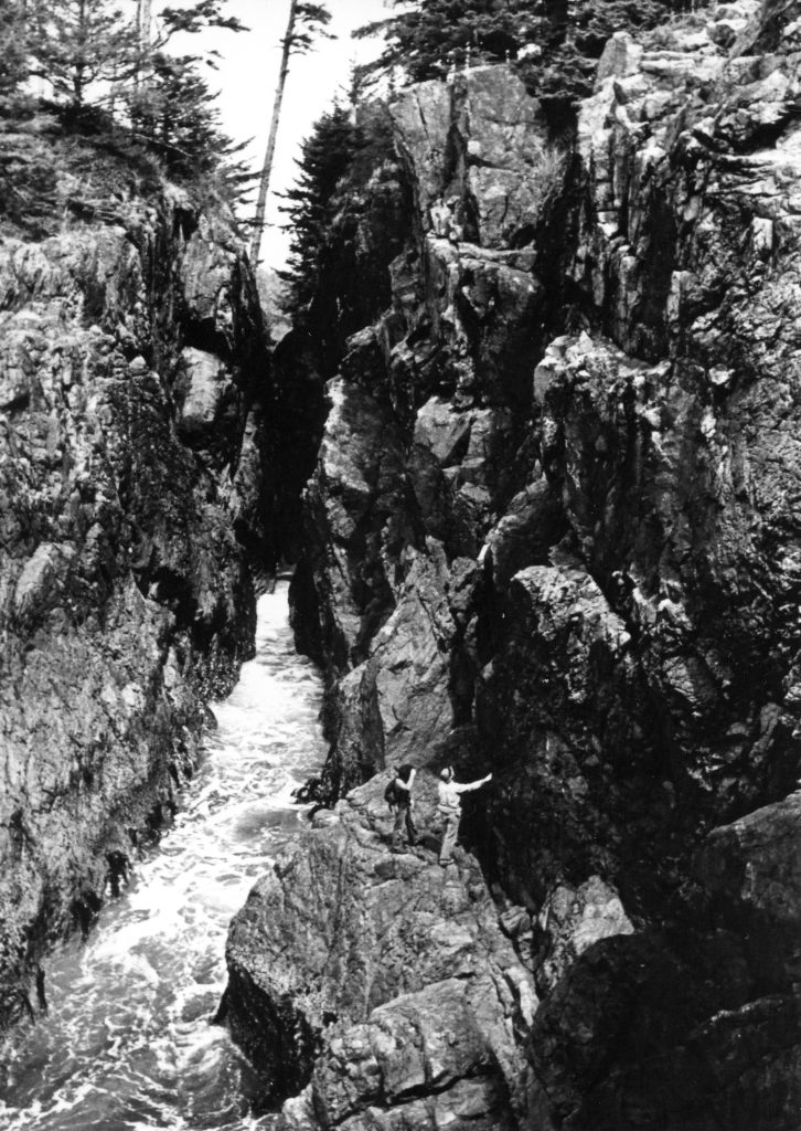
Bill Perry checking out the rock walls at the sea cliffs in Ucluelet 1970s – Bob Tustin photo.
Island Ramblings
By Nicholas A. Dodge
In 1972 we decided to climb Mt. Laing, previously noted in Culbert’s Guide as an unclimbed peak on Vancouver Island. It’s only 5800 feet, but wow! here comes the brush. From Buttle Lake we got it right to it. You know the old guidebook advice – stick to the ridge, etc. There wasn’t any ridge; furthermore, the trees blocked out any view whatsoever, so that our topo map was our only sense of security, unless you count the altimeter. It kept saying that we already arrived at the flat spot on the bivouac ridge! One of the disturbing things I saw on route to that high camp was a bunch of orange plastic tape. That made me very suspicious that we were fighting a lost first ascent, but why was it necessary to place anything there at all? Some broncos with less experience maybe, but BC Bush Buster? The summit is a nothing but the approach is OK. Lots of cul-de-sacs, snow flurries, and an occasional glimpse of wild country that was super! We had one other interesting observation. About half a mile below the summit there are a couple of large old-old blazes on some stunted firs. I think they could have been placed there by the original government surveys in the mid-1930s. After our usual soaking we opted for Strathcona Park Lodge. The proprietors there, understanding our plight, let us dry out all our soggy junk while plying us with good wine and steaks. After a day of this our restless souls made us move again – this time for those mythical unclimbed giants at the head of Nootka Sound. The weather was horrible as we pushed on to the Gold River. We took the Uchuck III to Tahsis but the weather never improved. we explored the island further including Flores Island and Ahousat but no more mountains were climbed.
1973
ACCVI executive:
Chair – Roger Neave
Secretary/Treasurer – Gil Parker
Climbing – Syd Watts
Events:
February 17/18 – Club members use the ACC Whistler cabin for the weekend.
February – Mark Mitchell led a trip to Empress Mtn. which included Pamela Mitchell, Ethne Gibson, Bill Lash and Ted Goodall.
March 18 – Syd Watts led a trip up Heather Mtn. with Doug Wylie, Hank Williamson, Bill Lash and Gil Parker.
March 24-April 8 – Dave Tansley, Judy Loretan, Ted Goodall and Roger Neave attend the annual ski camp at the Wates Gibson Hut.
April 13 – Club’s annual banquet is held at Holyrood House. Graham Wallis gave a presentation of his 1972 Nepal trip.
May 19-21 – Scheduled trip to Mt Schoen to be led by Syd Watts.
June 2/3 – Scheduled trip to Mt. Arrowsmith to be led by Roger Neave.
June 16/17 – Alan and Tim Robinson, Syd Watts, Walter Latter and Doug Wylie climb Mt. Septimus.
June 30-July – John and Doreen Cowlin, Brian and Aileen Foan, Sharon Harshaw, Brian Johnson Orianne Webber, John Gibson and Syd Watts flew to Bedwell Sound but failed to summit Mariner Mtn.
July – Rick Hudson and John Collings climb the north ridge of the Piz Badile in the Bregaglia Alps of Switzerland. (see R.D. Hoare. “The N. Ridge of the Piz Badile.” MCSA Journal, Vol. 76, 1973: pg. 86-88.)
The Northeast Face of the Piz Badile with the North Ridge on the right.
July – Joe Bajan, Tom Muirhead, Stuart Wazny and Dave Smith make 1st ascent of Elkhorn’s North Ridge.
July 15-22 – John Gibson and Syd Watts climb Mt. Schoen and explore the Sutton Range.
July 20/21/22 – Judy Loretan, Doug Wylie, Bob Cameron, Gil Parker and Mike Siska climb Mt. Schoen. Gil Parker leader.
August 13-17 – Ray Paine and Joe Bajan attempt a route on Mt. Colonel Foster up to the Southeast Peak from the Snowband.
August 18/19 – John Gibson led a party of six to the summit of Pinder Peak.
August 27-September 1 – Joe Bajan and Mike Walsh complete a traverse of all six peaks on Mt. Colonel Foster.
Ralph Hutchinson, Paddy Sherman Roger Neave and Scipio Merler climb Mts. Kilimanjaro and Kenya.
September 1/2/3 – Scheduled trip to Mt. Mitchell via Augerpoint.
September 16 – Scheduled trip to Mt. Arrowsmith.
September 23 – Scheduled trip to East Sooke Park.
October 6/7/8 – Scheduled trip to the Olympics.
October 20/21 – Scheduled over-night trip to Mt. Todd.
November 18 – Francis Chisholm led a successful trip up Empress Mtn.
November 30 – The Annual General Meeting of the section held at the banquet room of the Sherwood Park Motel, Gorge Rd. Phyllis Munday to talk on Mt. Waddington.
Hard-Pushing Skiers Seek Own Backyard Slopes
Mounts Hall, Arrowsmith Vie For Provincial Cash
Reported in The Daily Colonist Wednesday February 7, 1973. p.18.
By Rodney Wade
PORT ALBERNI—Skiing is a competitive sport, and there are no athletes more competitive than skiers out to develop their own backyard slopes. Contenders in a tourney which is now in its preliminary stages are Mount Hall near Ladysmith and Mount Arrowsmith located off the Parksville-Port Alberni Highway near Cameron Lake. Action was stirred up a year ago when a press release issued by the Socred government announced that administration’s intention to develop Mount Hall into a winter playground. The object was to provide basic sports facilities for the people of Greater Victoria. Only 67 miles from the city and able to draw on an immediate population of 100,000 it was felt Mount Hall was the ideal location.
Idea Sprouts
The press release triggered ideas in the minds of the skiing fraternity in the Alberni valley amongst whom were many of Port Alberni’s more prominent businessmen. In April of last year, a delegation from the local Chamber of Commerce met with Ken Kiernan, Socred conservation minister, and asked him whether or not the provincial government would develop Mount Arrowsmith’s Cokely Ridge as a ski park. They were turned down on the grounds that Cokely was too far from Victoria.
No Rejection
Later in the year a second delegation, this time representing the Arrowsmith Ski Club trekked to the capital to huddle with Wesley Black, the Minister of Highways. Their purpose was to request the government to put in a paved road. Black did not turn them down. He said it could be considered but that in any event the road must be thought of as going to a regional park rather than a commercial ski area. September brought a change of government. On December 18 a delegation that included members of the Chamber of Commerce, representatives of the City Council, Ski Club officials and people from the Parksville Tourist Association met with Bob Strachan. They were told quite bluntly that there were no provincial funds available for an access road.
Meet Arranged
They were referred by Strachan to Bob Williams Minister of Recreation and Conservation. Unfortunately, local MLA Bob Skelly was unable to arrange a meeting with the minister himself. However, he did set up one with the deputy minister, Lloyd Brooks. Also at the meeting was Bob Ahrens, the director of parks for the province. This meeting was held January 17 and lasted two and a half hours. The end result, however, was just as it had been at the previous meetings. The government re-affirmed the position taken by the Socreds. The deputy minister indicated to the delegation that the government had no particular hangup over developing a high-class facility. Their major objective was to provide an adequate, low key winter sports facility within one day’s drive of Victoria. The deputy minister also pointed out that the department of recreation and conservation could not put funds into an area that was not a provincial park. At this time an appraisal is being undertaken of the Crown Zellerbach land by the government in order that a final estimate of costs may be made. Cokely Ridge is termed a regional park and therefore could not qualify for financing from recreation funds. Upgrading of an access road to the west ridge of Lookout Mountain had been started last year. Apparently, the land in question is partly Crown land and partly owned by Crown Zellerbach.
Talks On
Negotiations with the company are in progress. He added that the nine miles stretch of road would cost in the region of $450,000. This would no include the costs of parking lots, a shelter and a modest ski facility. The president of the local ski club, Joe Van Bergen said that at least three studies of the Cokely Ridge area have been made on behalf of the regional district of Alberni-Clayoquot. One of these included comparisons with other ranges including Mount Hall. Facts emerging are that the cost of putting an access road through to the ridge from Cameron Lake would be between $250,000 and $500,000 dollars. Indeed, the margin widens if you consider the provincial government estimate of one and a half million.
More Skier Days
Cokely Ridge offers up to 35,000 skier-days of activity which compares favorably which well-known Forbidden Plateau which offers only 25,000 skier-days. In addition, Cokely has long run potential which Mount Hall lacks, says one report. It is worth noting, too, that during a mild winter such as we have experienced up until now, Mount Hall has been unskiable in contrast to Cokely Ridge on which skiing has been possible since December. Also, Cokely is only an extra 50 minutes’ drive from Victoria – still well within being a day’s drive from the city.
Most Suitable
According to one report, the Cokely Ridge has the most suitable location of all places surveyed on southern Vancouver Island for the immediate development of full range facilities. This site analysis prepared by Resources for Recreation Associates in December 1971 looked at five Island areas: Rogers Ridge beyond Campbell River, Forbidden Plateau near Courtenay, Cokely Ridge, Mount Hall and Green Mountain situated west of Nanaimo in the Arrowsmith region.
Company Forms
The project for the west ridge of Lookout Mountain is conceived of as being provincially run. The Cokely Ridge project would operate commercially. Van Bergen said that the skiers have already formed the Arrowsmith Development Company and are presently waiting to go public. “In order to ascertain the degree of local support for such a venture, we put some shares last year at $1000. We reached our target of fifty very quickly,” he said. Share in the public company would be sold at $100 and officials anticipate a fast sale. By this method the company would be able to develop facilities, tow ropes, lodges and allied necessities. Van Bergen was sure they could raise one million dollars in this community alone.
Ney Speaks
Last week, while on a speaking engagement at the Chamber of Commerce installation ceremony in Port Alberni, Nanaimo, Mayor Frank Ney had something to say about tourism on the island and commented on the proposed development of Cokely Ridge. In his speech he looked ahead to the time, perhaps within the next decade when visitors from California would be swamping the B.C. countryside during the holiday season. He said that Vancouver Island was one of the more popular holiday spots for refugees from Southern California smog. Airline fares would also be another factor in the growing popularity of the Island he said.
New Road Helps
Projections indicate that air fares were going to drop rapidly. This effect would be to open the west coast to more Canadians from the East, more Americans and even greater tourist influx from Europe. This could mean a major location such as Arrowsmith could benefit from the tourism trade. Last year over 200,000 people passed through Port Alberni on their way to Long beach. The new road had now made travelling a simple process and so the number of tourists could be expected to double in five years. When asked about the significance of the Cokely Ridge project Ney responded: “It certainly merits government support.” Meanwhile skiers in this valley have no intention of depriving, or attempting to deprive the people of Victoria of simple winter sports.
No Deprivation
“We think that the Mount Hall facility can only do good for the sport of skiing,” said Joe Van Bergen. “It will certainly not deter from anything we are doing. But our point is that there are no funds available to develop access to a regional park.” It seems that though the deputy minister indicated that funds could only be available for provincial parks, the west ridge of Lookout Mountain does no lie in such an area. It is partly on Crown Land but largely on property owned by Crown Zellerbach. In contrast, however, the land to be used at Cokely Ridge has been donated to the Regional District by MacMillan Bloedel for use as a regional park. A letter of intent to that effect has been signed.
Approval Needed
The Arrowsmith Development Company would lease the land from the regional district. But in order to do this final approval would have to be given by the provincial government. For the latter reason it would seem that the Cokely Ridge area is closer to Provincial Park status than is Mount Hall. A keen and well-organized group of local people, with wide support has already raised money and is prepared to develop an area that will attract not only the tourist dollar but will help to spread the load in a fast-growing sport.
Simpler Style
They understand the government’s intention to provide a simpler style of winter sports area and agree that closer proximity to large urban centres makes a lot of sense. But they feel that it would not be too much for the provincial government to provide an access road. For, says Van Bergen, that is all they want. They have the tools, they have the enthusiasm, they have the broad-based local support, they have an area that could be developed into a year-round outdoor sports centre with a full range of winter activities, including longer-lasting snow. “Give us the access road,” they say, “and we’ll do the job.”
The Mackenzie Range
June 30 – July 2, 1973.
Reported in The Timberline Tales of the Island Mountain Rambler. p.14/15.
By Bill Perry
After waiting an hour and checking both Canoe Creeks (the one on the topo map and the one all the locals call Canoe Creek), it seemed obvious that nobody was going to show up. Also, it was getting hot. I was so revved up for some climbing that I decided not to let lack of company hold me back and commenced to meander up Hard-To-Follow Ridge. Four hours at a leisurely pace put me in the alpine and a perfect campsite was found on top of False Peak (this and most other names of the terrain features which follow are unofficial ones made-up by Mike Walsh and me for convenience in referring to various peaks and approaches). After supper I decided to see how far up Redwall Peak I could get and return to camp before dark. Redwall is the pinnacle that looks so impressive from the highway below when coming from Port Alberni. It had been climbed once before by Dick Culbert and Ted Stevens in 1960. I managed to get up and down it with time to spare, since the class 4 section is only about 60 feet. The rock is good and the summit yields fantastic yodel echoes from the steep rock walls above the north bow. One rappel, a bit of down climbing and across the silver saddle to camp.
Free at last
from rock and scree
The snow’s long shadow
July 1st was socked in and drizzly. I spent the morning writing a few things and mostly trying to empty my mind of everything and let the mountain communicate with me. It was a calm and beautiful time. Around noon the weather brightened a bit and I set out to attempt Witches Hat and The Centaur, the two northeastern most pinnacles of the main group of six. They were first climbed by Mike Walsh and Ron Facer and had not been attempted since. The Centaur is especially noticeable as a separate pinnacle from the Ucluelet area and I had wanted to climb it for a long time. I had climbed to a wide sloping ledge just below the point where the two pinnacles separate when a small rock beneath my right foot rolled. I reached forward quickly with my left arm to regain my balance and I felt a grinding, sharp pain in that shoulder. The arm had been caught inside the elbow on a loose pack strap which had slid down off my shoulder. Now my arm was stuck out from my body at a crazy angle and could barely be moved. And the shoulder hurt like hell whether I moved or not. Dislocation. I knew it immediately. Complications: Nerve damage? Don’t think so – no numbness or tingling. Loss of circulation? Nope, pulse OK. Symptoms: Apprehension. For sure. That’s the nice word for it. But that passed over quickly. Suddenly my mind was unexpectedly clear and logical. Treatment: immobilize in position of most comfort and evacuate to medical aid. Well, uh, yes, but there’s a few problems, you see … Like the fact that the last few hundred feet had been mostly class 3, which I now couldn’t down climb. Fortunately, there was a moderate snow gully only 50 feet below which connected with the beginning of the technical climbing. Reaching it involved a rappel down an overhang the whole way. This went down smoothly enough except that I was unable to pull the rope down. Too weak and awkward with only one hand, I guess. Getting back to camp took a long time. It seemed more like a climb than a scramble as I gradually got used to my limitations. (Ever try a narrow chimney one handed?) At camp I stashed the climbing gear and picked up extra clothing which would be handy if I had to spend a night in the bush on the way out. Glissading was the most comfortable way to descend the snow slopes though it would have appeared pretty grotesque if there had been anyone there to appreciate it. The ice axe was held in the good hand, the pick end supporting the injured arm in the above-mentioned weird position. Luckily, I didn’t fall. My recollection of the rest of the descent is short of a painful blur. Again, the time dragged and simple movements seemed clumsy and complicated. About 1000 feet above the highway the pain became worse. As I rested the shoulder suddenly “relocated” itself. It’s hard to describe the relief unless you’ve had a dislocation, in which case I don’t have to. I was now able to place the arm in an improvised sling and move faster, arriving at the car half an hour before dark. On July 8, one week later, Milt Rocke accompanied me to False Peak, and packed down all the equipment that had been left in camp. Rain and thick fog prevented us from going after the rope. On September 16, a postponed Tit Mountain [Pogo Peak] trip was diverted to the Mackenzie Range, and we brought the rope down. Bob Tustin Lynn Paterson, Bryan Lee and I climbed to Perez Lookout for the view of ocean, islands, lakes and mountains. Then Bryan and I scurried down to get the rope. A couple of hard tugs and down it came I don’t believe there is any lesson to be learned from this accident. The climb illustrates to me at least, the rewards as well as the drawbacks of solo climbing, and I’ll probably climb alone again occasionally as soon as the shoulder mends. The same type of accident could have happened on a sidewalk. The exact effects of weathering on rope are not known. It is known that direct sunlight weakens rope, but not to what extent. A piece of rope left in the Mackenzies is being sent to Mountain Safety Research in Seattle for testing.
Mt. Schoen
July 14/15, 1973.
Reported in The Timberline Tales of the Island Mountain Rambler. p.25.
The party met at the Lake Schoen camp on Saturday evening. At 5:45 a.m. six of us made our way in three canoes to a beach on the east side of Schoen Creek. Hiking started at 6:15 a.m. and was led by Syd Watts who soon found an elk trail, which took us to the timberline, at the foot of the alpine bowl to the south of Mount Schoen. Coming to the right of this brought us to the ridge leading up to the main ridge joining the main peak, to the south peak. This provided some rock pitches of about 200 feet of easy standard. We stopped for lunch after this, and Syd, John and Warwick made a detour to the south peak where they had excellent views of the main summit, east ridge, and to the south, Warden, Victoria, and Sutton Peaks. After traversing the ridge, we climbed the final steep rise to the summit arriving at 3:15 p.m. This has almost vertical walls in most areas and we had good views of Lake Schoen 5000 feet below and to the east Nisnak Lake and the meadow around the headwaters of the Adam River. Descent was to the main ridge then via a gully to the snow bowl and thence by the same elk trail to the canoes. Camp was reached by 9:00 to 10:00 p.m. depending on whether one wanted to get out that evening or not.
Participants: Syd Watts, John Gibson, Inno Schaeffer, Warrick Whitehead, Alan Robinson, Don Bollnerhouse.
The Day Of Foster
August 13–17, 1973.
Reported in The Timberline Tales of the Island Mountain Rambler. p.4/5.
By Joe Bajan
Once after getting home from being away for five weeks, and not having done any climbing since Elkhorn Mountain June 1-4, two nights at home were enough to encourage me to start looking for someone to do some climbing with. After a few phone calls Ray Payne and myself made plans to set out for Mount Colonel Foster. I had Foster in the back of my mind ever since seeing pictures and hearing of it over a year and a half ago. Ray and I got together at Bob Tustin’s at 2:30 a.m. after Ray just got down island from climbing the Golden Hinde. After doing laundry, shopping, swimming and coffee at Strathcona Park Lodge we finally camped at the head of the Elkhorn valley. (Probably one of the longest records ever to get up island.) Another day passed while it took us all day to get up to Landslide Lake. We had all intentions of getting up at 4 a.m. to get a fairly decent day in, but as the night rolled in Mother Nature wanted to play games with us. We got up at exactly 4 o’clock (15 minutes late). It was beautiful outside all nice and cloudy, wet, and rainy. After a whole morning of cloud, sun, and showers we finally pushed off at 10, all went well till we got to the rock break in the snowband. Just as we were getting out our gear for the first lead the storm hit us. It deposited about half an inch of hail in about 10-15 minutes. But with still full intentions of making it to the summit we pushed on. From here on the storm got progressively worse. One minute it was hailing, the next snowing, then raining over and over again. We set 4 p.m. as our turnaround point; 4 came around and we were nowhere near our objective. There was no way, no way that we were going to get down the same rock we came up in this weather. So, no other choice but to bivouac. We kept going up and looking for a spot. But none was to be found. Six o’clock came around leaving Ray to pull up the rope and get a hot drink and some food going. I went up high to look for a bivouac spot but found none. On the way back I got lost in the storm and only found my way back by Ray’s voice. After a hot drink and some food, we decided we had no other choice than to go down. It would have been fairly nice rock climb in good weather but there was no way we could do that now. We had to rappel all the way down. For the first rappel we didn’t use a sling, just dropped the rope over a rock but soon found that it didn’t work. So, I had to climb back up and put a sling in. The last two rappels were in the dark. The last one without a sling because we had run out. Even after undoing the ones with nuts on them, I couldn’t find a single crack to put a piton in. I finally found one but the piton would only go half way in. Not telling Ray this, we were rappelled off it down to the snow slope below. Then finding out that the rope was caught. Three and a half hours and 13 rappels later after our stop we were off our major obstacle. Nothing much happened between then and 2 a.m. when we got back to our camp, other than a fall by Ray that dragged me down also. It could have been close to killing us both and Ray losing his ice axe. Getting back to our tent there was an eventful moment as I found out that all I had to sleep in was dry booties, damp jeans, and a soaked T-shirt. A short restless night was enough encouragement to tell us to get out. The search of further excitement was found in the form of the “Gold River Pub.” Even though we were a failure in our objective this was a most rewarding trip.
Mount Colonel Foster
August 27 – September 1, 1973.
Reported in The Timberline Tales of the Island Mountain Rambler. p.31.
By Joe Bajan
After getting off Mount Colonel Foster in the dark, in a storm, you would have thought that, that would have been enough excitement for a while. Little did I realize that I would be back there ten days later with Mike Walsh. Once more we camped at the Elk River valley, and again a full day to get to the valley. This time the delay was not laziness, but Mike giving hell to a bunch of “boy scout type campers”, who were building lean-tos and a fire five feet from an old fire spot. Another day passed as it took us all day to get from Landslide Lake to our camp in the South Col. This delay was again a wait for better weather. The third day was the first day of our objective, the first complete traverse of the six peaks of Colonel Foster. (The traverse was first attempted by Mike Walsh solo, then with Mike Walsh and Bill Perry, both were failures in a complete traverse.) An easy scramble to the low Southeast Peak which has perhaps been climbed by a dozen people. Upon reaching the peak I discovered that two weeks before, in the storm, that I had gotten to a point of about forty feet from the summit, which would have been as hard as walking up your basement stairs in the dark blindfolded. A very tricky traverse across a narrow ridge led us to the high Southwest Peak. Then came our hardest pitch of the climb a down pitch which we ended by rappelling down. Then a leisurely stroll across the snow band and up to the summit, which has had five different people in four ascents. Mike has climbed it three times. Here we established the highest camp yet achieved on Vancouver Island. Here we went about a day and a half without any water because there was no snow to be found as expected. Next day we found one of Dick Culberts slings at the point where he called it a vertical bowling alley. We down climbed the same rock that Culbert and friends rappelled off. That really made our day. After a quick dash up the North Peak without packs, into our last camp in the North Col. As usual, we came off the mountain in the dark.
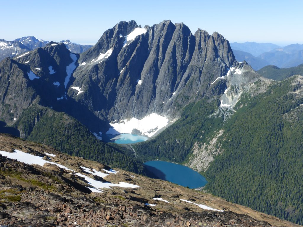
The East Face of Mt. Colonel Foster from Elkhorn – Lindsay Elms photo.
WHY
By Joseph P. Bajan
Ever since seeing it three years ago,
a small flame flickered that I was to do it.
A smaller one sparked that I had to do it alone.
Not Last season or next but now.
WHY prepare myself and the night before
attempt to destroy it.
Knew that I had to but
Knew that I wasn’t supposed to.
WHY start so late, then race in
two and a half hours faster than any time before.
That evening with my eyes full of the mountain,
saying NO, YES at the same time, each over-riding the other.
That night getting up gazing there in the moonlight,
asking myself WHY?
That morning rushing with the sunlight to meet
the mountain, asking WHY saying NO!
Climbing the face, fear trying to creep in
but casting it out each time. Minding thoughts
of the day. Death flashing by.
WHY? Halfway saying that it was wrong
that I shouldn’t be here, about to turn
back but didn’t.
Driving myself to my utmost limits
but retreating each time.
Gorging with snow trying to overcome
thirst, but to no avail.
Muscle and mind co-ordinated, one outracing
the other with near catastrophe.
Sleeping; trying to forget that I was here.
Awaking to a world of spirit against muscle,
muscle against man, man against rock.
On the summit echoing a cry of joy, a kiss
upon the rock, but without a heart.
Looking onward to other horizons, trying to
be amazed by the panorama.
Virgin rock within the rapists’ hand
but letting it pass. WHY? To come again?
Descending with might instead of mind.
Cursing the mountain and not I.
Meeting other souls speech flowing
with utter rejoicing, but knowing otherwise.
Racing out the valley WHY? For there was
no other mountain awaiting me.
WHY had I gone? If it were the mountain
others would have come. WHY alone?
WHY had I gone?
For I’ve been there before,
were there riches beyond
my dreams?
To become older and wiser?
For if that I would know WHY.
The mountain was Colonel Foster, the east face. Basically, a repeat of Dick Culbert’s route, except when I reached the main snow patch on the face I remained in the gully while Culbert moved onto the ridge. The two routes rejoined again about 500 feet below the summit at Culbert’s bivouac spot (CAJ 1973, page 34). Descent was made to the south over the southern skyline to the Snowband. Down this to and across the rock break. From here it is recommended to rappel all the way down to the lower snow band and not try to down climb the last pitch even though it looks feasible. The rock is extremely rotten there. Rest of the descent is straightforward back to the lake. This is probably the fastest and best escape route off Colonel Foster now. Ascent was made in 5 hours (solo, unroped) with the descent in 3 hours. A very fine climb averaging about class 5.5.
Frosty Night On Mountain
Reported in The Daily Colonist (Island News) Thursday October 10, 1973. p.13.
A 19-year-old Victoria girl, who was lost for 24 hours in rugged mountainous country in the Forbidden Plateau area on mid-Vancouver Island, was found suffering from exposure by searchers Monday afternoon. Beverly Biram was flown out by Okanagan Helicopters to St Joseph’s Hospital, Comox, for observation. Miss Biram lost her way while camping with members of the University of Victoria Outdoors Club in Strathcona park. Courtenay RCMP said Tuesday that on Sunday the girl and three other members of the club went to Amphitheatre Lake via the trail from their camp past Circlet Lake. When the other members started to fish, Miss Biram headed back for camp. Members of the outdoors club started searching for her, with no results, after she had not returned to camp within three hours. Police were notified and an official search party organized. After spending the night in severe frost, Miss Biram was discovered at Sims Lake, many miles from her destination.
Alpine Members
Reported in The Daily Colonist Thursday November 29, 1973. p.38.
Annual general meeting of the Vancouver Island section of the Alpine Club of Canada will be held at 8 p.m. Friday [November 30] at the banquet room of the Sherwood Park Motel, Gorge Road. Phyllis Munday will present a slide talk on early explorations of the Mount Waddington area.
Vancouver Island
Reported in The Canadian Alpine Journal Vol. 57, 1974. p.62.
By Bill Perry
The winter months saw an amazing increase in X-country skiing on the island. Four winters ago, hardly anyone even knew what X-country was. Now it seems everyone is discovering the Island’s miles of unplowed roads, which provide ideal terrain for nordic touring. In some areas, people have even discovered the real purpose of the snowmobile: that’s right – packing out XC ski trails. The Islands Mountaineering clubs all had impressive looking schedules but a lot of trips seemed to never get off the ground. I think this was more due to climbers being away during the summer than lack of interest. A lot of good things did happen though many of them not planned, or foreseen before the season. In early September Mike Walsh and Joe Bajan traversed all six peaks of Mount Colonel Foster from south to north. This is the first complete traverse. Mike and I [Bill Perry] skipped the north peak in our north-south traverse two years ago. Joe was also involved in establishing a new route on Elkhorn’s north ridge earlier in the summer. An Island Mountain Ramblers group visited Flower Ridge and Mount Septimus in July, and most one day hikes and climbs were well attended. Interest in all aspects of mountaineering seem to be slowly increasing in the area. We now have the first ever course in the subject outside of Victoria being taught by Bob Tustin in Port Alberni. It would seem that while not as many new things are being done there is a more interest in less difficult climbs. I attribute this to there being more beginning climbers. From this more broad-based group there will emerge a few who will be more turned on by the challenge of the Island’s peaks then turned back by the brush and uncertain weather. I think the next few years we’ll see more new routes in first ascents of Island mountains by island climbers.
1974
ACCVI Executive
Chair – John Gibson
Secretary/Treasurer – Gil Parker
Climbing – Syd Watts
Editor – Cynthia Tansley
Events:
January 20 – Section trip to Ragged Mtn. led by Adam and Stan Ford.
January 26/27 – Section members stayed at the ACC Whistler hut for the weekend and attempted to ski up to Singing Pass.
February 24 – Scheduled trip to Mt. McDonald.
March 2 – Scottish climber Dougal Haston gave a slide presentation at the Newcombe Auditorium on Everest and Annapurna.
March 2/3 – ACC Whistler cabin booked by section.
March 15 – Club’s annual banquet held at the Holyrood House. Roger Neave and Ralph Hutchinson showed slide of Mts. Kenya and Kilimanjaro. Tickets $4:25 per person.
March 16 – Scheduled trip to either Mt. Sutton or Mt. Landale.
March 24 – Scheduled trip to Wolf Creek Hills via Todd Creek.
April 20/21 – Scheduled trip to Whistler skiing.
May 4 – Scheduled trip to Mt. Arrowsmith.
May 18-20 – Scheduled trip to Mariner Mtn. Fly into Bedwell Sound.
June 8/9 – ACCVI party climbed Mt. Septimus.
June 29 – Scheduled trip to Victoria and Warden Peaks.
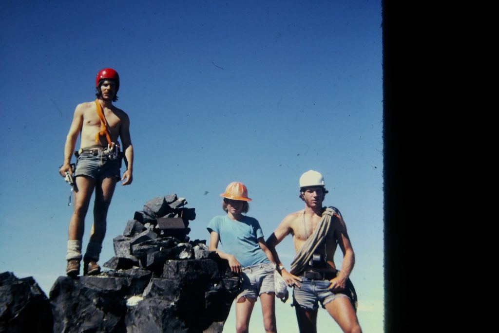
Climbers on Victoria Peak 1974 – Ernie Klassen photo.
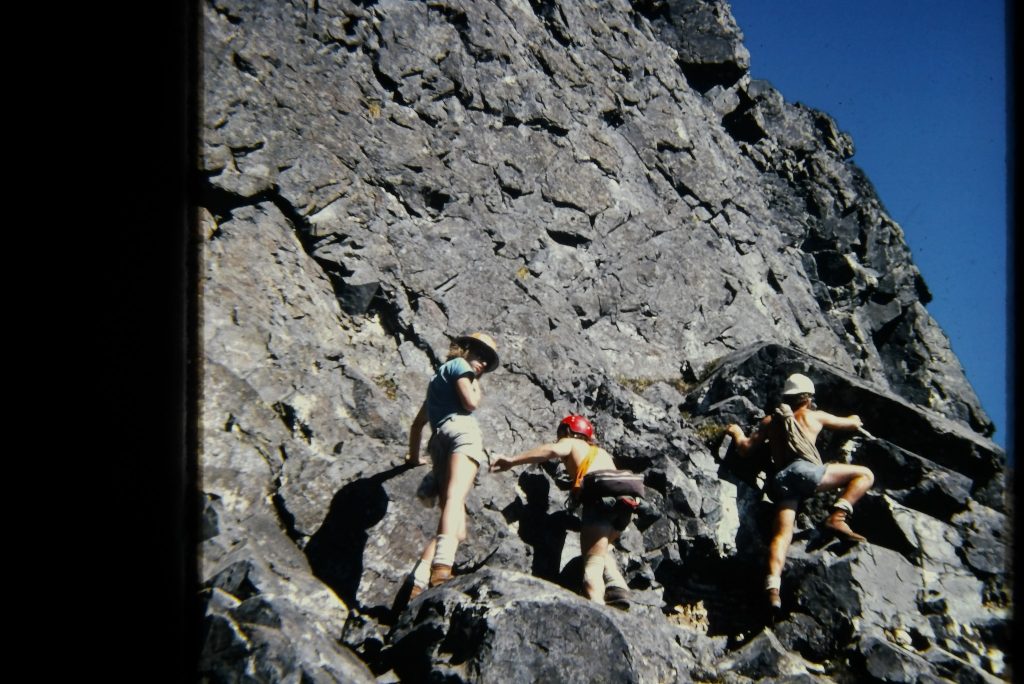
Climbers on Victoria Peak 1974 – Ernie Klassen photo.
July 13 – Scheduled trip to The Lions near Vancouver.
July 15-22 – Syd and Emily Watts, and John and Mary Gibson explore north island and join up with an IMR trip to Mts. Hapush and Schoen (climbed by John, Syd and Alan Robinson).
July 18-August 28 – Rick Hudson was the leader of the Cambridge South Greenland expedition that included Phee Hudson, Greg and Ineke Mosely, Dave and Susie Cornell, Jeffrey Moeller (USA), Tim Hurrell (UK) and Gordon Hickson (UK). They climbed from three base camps—the first on the east side of Kangersuneg quingordleq, the second on the south side of Nup Kangerdlua and the third on the island of Pamiagdluk, directly south of the village of Augpilagtoq. They enjoyed good weather and made 20 first ascents (mostly around 1500 m) including Salugssugut Peak (1685m) and Majorteqe (1300m). (see R.D. Hoare. “Of Peaks and Pairs and Polar Bears. Cambridge South Greenland Expedition, 1974.” MCSA Journal 1974, Vol. 77: pg. 20-26; and R.D. Hoare. “Majorteqe Peak 1300m, 1974.” The Alpine Journal 1975, Vol. 79: pg. 203-209.)
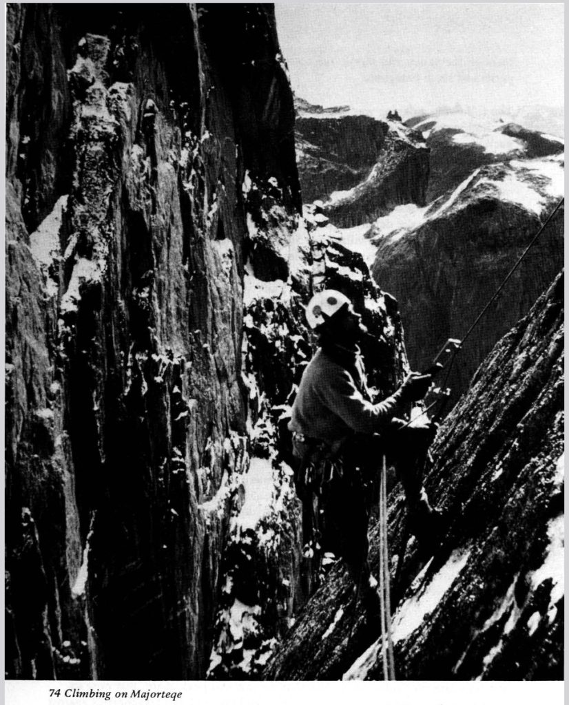
Climbing on Majorteqe – Rick Hudson photo.
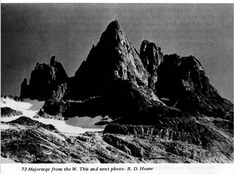
Majorteqe Peak from the west. Rick Hudson photo.
August – Ralph Hutchinson, Roger Neave, Bill Perry, Franz Bislin, Mike Walsh and Bob Tustin attempt Noel Peak in the Stikine Icecap.
August – Ralph Hutchinson, Jim Taylor and Jim Shabbits make the 1st ascent of the Judges Route on Mt. Arrowsmith.
August 19 – John Gibson and Bill perry climb Pinder Peak.
August 31-September 2 – Five members of the ACCVI attempt Rugged Mtn from Woss Lake.
September 14 – Gil Parker and Doug Wylie climb Mt. Mitchell and Auger Peak.
September 23 – Jean and Frank Mosely led a trip to Esst Sooke Park.
October 8/9 – Gil Parker and Dave Tansley climbed the southeast and southwest peaks of Mt. Colonel Foster.
October 12-14 – Syd Watts leads a trip to Mt. Myra.
October 21 – Dave Scandrett, Claire Ebendinger, Ron Cott, Gil Parker, Cynthis and Dave Tansley climb Mt. Todd.
November – The Annual General Meeting of the section was held at Sherwood Park Inn. John Gibson gave a slide show on the Schoen-Sutton areas and Rugged Mountain area. Roger Neave also presented slides of a recent expedition to the Stikine Icecap.
A letter was sent to the Parks Department re: Schoen-Tsitika, supporting the idea of a park. The suggested boundaries were submitted by the Section following a recent club trip to the area.
A suggestion was made by Gil Parker that the Climbing Committee set up a list of graduating climbs on the Island and that these be recommended to the Main Club.
Fred Maurice convinced Pemberton Homes to produce the Sections newsletters (Crag ‘n Crevasse) in return for nominal advertising.
Section dues:
Section members $4
Life Member $3
Dougal Haston Slide Lecture
Reported in The Victoria Express Saturday March 2, 1974. p.17.
The Alpine Club of Canada presents Dougal Haston showing films and slides of Everest and Annapurna at the Newcombe Auditorium March 2 at 8 p.m. Adults $2:50, children and old age pensioners $2:00.
On The Slopes
Reported in the Victoria Daily Times Monday March 22, 1974. p.4.
By Claude Lamontague
The possibility of a ski resort on Coronation Mountain, about 10 miles from Chemainus, as the crow flies, still exists. In answer to a letter of enquiry sent from the Ladysmith Town Council, an official of the Department of Recreation and Conservation advised that although no development has yet taken place, the Department is still gathering technical data on snowfall, ski conditions and weather. This will continue into the spring. During a visit to Victoria, last week, Alderman Doug Brown and Kay Grouhel dicussed the possibility of the development with another government official, Assistant Deputy Minister of Housing, George Chatterton, who said that he had flown over the area recently and is very enthusiastic about the idea. The government has tentatively given the name White Crown to the area proposed for development. Mr. Chatterton urged that Ladysmith Service clubs write to him at the Legislature Building in Victoria pressing for the development of the area; it might be a good idea for those of us here to do the same thing.
Filberg!!
May 1974
Reported in the Timberline Tales the newsletter of the Island Mountain Rambler, p.28/29.
By Kim Hutton
A mottled sky hovered above us,
And a gentle breeze dusted the rocks;
Where we sat
Munching on apples
And nibbling pieces of chocolate and cheese
Five thousand feet and still climbing,
The summit of Filberg off to the right
And dropped, suddenly, deep into the valley below.
A bowline clung tight to our waists
And slack had to be gathered in both directions.
Each step is tested,
For the snow is wet
And slides like soap across a glassy top.
Maybe a hundred, no two hundred feet of ice
Climb by degrees before us,
Each move had to be planned
And the steps cut,
Or knocked out with the toe of your boot
The cold penetrated and burned the fingers.
And beads of sweat dried to the brow.
The summit now lay before us,
Our goal achieved we relaxed,
And sipped on bottles of water and ice
That eased our parched lips and throat.
Now with five on a rope
We started the long precarious descent,
Standing flat foot and still
The slushy mess began to shift beneath my feet.
Falling!” my call rang out and echoed
Back across the valley
Thanks to the skill, and knowledge of my companions
My fall was broken.
Hunger nawing deep inside
And dusk drawing at our heels
We quickened our pace,
And started the two hour trek back to camp.
We walked cat like,
Soft poured, and gentle
Cross the snow fields and ice.
Carrying and testing
Each step, for fear
Of falling
Or being buried deep beneath
A sliding cornice .
Determination, cold steel,
Man against nature
Yet the sun smiles
Opens the skies.
And protects us.
Thoughts From a Week Trip to Rambler Peak
August 1974
Reported in The Timberline Tales the newsletter of the Island Mountain Ramblers. p.12/13.
Poem by Maragret Symon
Take me back, moon, to my mountain days
Rise again behind the silent rock Sentinels
Shine on the frozen snows that cling to precipitous walls
Blend black and silver and dance with the wind on
shivering tarns
And when the wind’s not blowing catch
and cast the heather in ethereal sterling
Rise, moon, and join the stars
Ride the night sky.
We were making our way, early one morning, across the icefield
on our way to climb. The wind was
racing down the col, sprinting to the valley,
shouting, tugging us, wanting us to follow. Suddenly it stopped.
All was still.
The first glint of sunlight was smiling at us,
Perched on the highest pinnacle of the mountain,
Pausing before it introduced a new day.
The sun smiled down upon us every day, and it warmed
the tarns and we bathed in their waters, and it nurtured
all the alpine flowers. We learnt their names.
Saxifrage, nodding their freckled heads in the breezes
Mist maidens and spring beauty growing ‘side the snow.
Phlox and fleabane, purple, and red, and white
There were penstemon, elephant head, pussytoes,
and western anemone, and by the time the moon had ridden
only a few night skies
There were tow-head babies blowing in the wind.
We climbed every day, but I remember one day
more than any other. It was the highest mountain we climbed,
the steepest, in the most beautiful.
Ever since I first set my eyes on the massif, I knew
there was something sinister about the mountain. It was
a different color than all the other peaks.
it was silvery-grey. A very beautiful,
evil mountain.
I can hear the ice axes clanging on the rock, and thoughts
reverberated from the depths of a Mesozoic soul we
dared to disturb.
Rock after rock we knocked, with apologies, down,
down,
down yawning chasms that dropped beneath us
several thousands of feet.
Soon we were higher than most of the other mountains.
Horizon slipped behind horizon.
We were on the top.
We ate our lunch on the Cairn and watched his first one,
and then two, and then four
Ravens flew high above the valley. None of us mentioned
that all remembered that Ravens are omens when
the wind is in agreement. We left
our names in the Cairn, and though we searched
we found no others where others had been
I had never been so anxious to be off a mountain in
all my life.
We rappelled down the snow slope, ever so slowly,
Down the outstretched tongue of an enormous ghostly being
Down it’s gaping rock walls, easing ourselves
lower from hold to hold. In the rocky gully
suddenly
a scream
the bang of an iceaxe
But no one was hurt and
once the shock was over we continued.
Wanting more than ever to be down.
Back at camp we watched the sunset behind the massif,
Saw the fading streaks of crimson die as the embers of a fire,
Saw purple behind a sawtooth silhouette.
And one of us said, “Slowly it’s disappearing.”
That night a waning moon rose behind
the silent rock sentinels. It was orange.
One of us said, “A harvest moon.” And we knew
the time had come to leave.
We left when the moon was still riding the sky
We hiked out the Creek valley, and the whine of mosquitos
droned on through the day.
We followed the elk trials in through cedar and hemlock
and through meadows green with hellebore and grass,
and with spruce trees, and high rocky pinnacles on either side.
Two black bears watched as we walked through
the wild lands that we made too much noise
to see any elk.
And then we were there, but before we reach the cars
We left something behind, each and every one of us, and some
more than others.
They say that freedom dwells in the mountains. And now
I watch for the moon when it rides the night sky.
I have left too much freedom behind.
Take me back, moon, to my mountain days.
Island Climbing Team Records First Ascent
Reported in the Nanaimo Daily Free Press August 12, 1974. p.13.
While some holidays loaf, fish, swim or relax in the sun, others prefer a more strenuous form of vacation. For instance, there is mountain climbing. A number of Nanaimo district men and others from Vancouver Island this summer formed an expedition to climb some of the previously unclimbed peaks on the BC/Alaska border. They battled snow and ice and poor weather to make first ascents of some unnamed peaks near the Stikine ice cap. The team of Vancouver Island Mountain Ramblers spent about sixteen days in the area. Nanaimo lawyer Ralph Hutchinson acted as leader of the expedition. Ten years ago, it seemed unlikely that Mr. Hutchinson would ever climb again. He had just returned from climbing with the Mount McKinley expedition in which he had suffered severely frozen feet resulting in the loss of the toes on one foot. He had been hospitalized in Alaska after being airlifted from the mountain camp, then had spent some time in Nanaimo hospital. For a long time, mere walking was a problem but in recent years he has been back once again at his favorite sport, mountaineering. Many other Vancouver Island climbers were in the Island Ramblers group, including club President Bob Tustin of Nanaimo. Well-known mountaineer Roger Neave of Nanaimo was a member of the party, as was bill Perry of Ucluelet, Mike Walsh of Victoria, and Franz Bislin of Port Alberni. Weather was poor until just about the last day of day. Climbing was hampered by poor visibility from fog. Much of the time was spent back-packing from base camp, as the team travelled to vast Stikine Ice Cap and returned by way of the North Baird Glacier to the point where the aircraft picked the men up. “We back packed about 80 miles altogether,” Mr. Hutchinson said in an interview. Boundary Peak ‘73 was one of the first peaks climbed. First ascents were made of an 8000-foot peak, one 8100 and one 8500. One of the unnamed peaks climbed by the Island Rambler group may be named Rambler Mountain. The team made a first ascent of the peak and now will suggest to the American government, because the mountain is on the American side of the boundary, that the name be officially given the mountain. The group flew into the area from Petersburg, Alaska. While falls into crevasses were all part of the game, the group actually experienced no serious mishaps and no injuries, least of all sunburn, Mr. Hutchinson added.
Annapurna
Reported in The Daily Colonist Wednesday August 14, 1974. p.23.
Today’s Highlights – TV program schedule on 2 at 9:30: A 1953 documentary film of the French mountain climbers conquering Annapurna, one of the highest peaks in the Himalayas (60 minutes). Why are they showing it you ask? Because it’s there.
Climbing Reports: Vancouver Island
Reported in The Canadian Alpine Journal Vol. 58, 1975. p.66.
The Vancouver Island Section had an interesting and busy season. The south peak of Mount Septimus was reached 8 to 9 June by packing up Price Creek from Buttle Lake, with a camp at Cream Lake a glorious area which might not last if mining activities get underway. John Gibson, Alan Robinson and Syd Watts spent a week exploring the Sutton Range and Victoria Peak, from where they climbed a 3000-foot snow gully up to the col between Victoria and Warden but were discouraged from further investigation by overcast conditions. They spent some time exploring the Nisnak Meadows in the Schoen area, having approached up the Adam River Road from the east. The meadows provided them with a number of delightful encounters with the local inhabitants, elk and their calves and a fawn, and a view of Nisnak Creek which comes off Mount Schoen in one of the most spectacular falls on the island. Mount Hapush and the west peak of Mount Cain were climbed, on good solid rock, from a logging road which comes off Schoen Lake Road. The east summit of Mount Cain appears to be slightly higher and more difficult and is probably unclimbed. Five members of the section attempted Rugged Mountain 31 August to 2 September. They reached the south end of Woss Lake by courtesy of Canfor’s power boat. Bushwhacking the old Tahsis trail and then up the ridge on the west side, they camped at 2800’ after having to negotiate an unexpected band of 500-foot cliffs. The following day they paddled across a small lake in a hanging valley and followed the ridge from the north end to the glacier on the east side. They climbed the glacier (one of the biggest on the island) to a minor summit on the main ridge. Time ran out before they reached the main summit, “a mighty pinnacle of bare rock looking remote and magnificent”. Gil Parker and Doug Wylie climbed Mount Mitchell and Augerpoint Peak 14 September. The approach was from Jack Shark trail on Buttle Lake, climbing Mitchell from the south with about 500 feet of rock climbing to the peak. On the weekend 12 to 14 October Mount Myra was approached by hiking the cat track along the water line up to Tennant Lake avoiding the north slope bush and following the south east ridge above the lake to the peak. Practice rock climbing became a regular Thursday night activity throughout the summer. Various locations around Victoria were tried out with a 200-foot cliff within 10 miles of the city becoming the favorite location. Three routes have been put up, difficulty up to 5.5.
By Cynthis Tansley
No first ascents to report. No new routes either. But an active year. Mounts Cobb, Filberg and Donner were climbed by large groups of Island Mountain Ramblers for the first time since the surveyors set foot on them in the 1930s. Joe Bajan, who often says, “I don’t believe in anybody doing anything stupid!” did a solo ascent of the 3000-foot east face of Mount Colonel Foster basically following the Culbert, Starr, Douglas route of two years ago. A BCMC/Rambler trip led by Ralph Hutchinson saw 25 people fighting for space to eat lunch on the summit of the Golden Hinde, the Island’s highest mountain. An observation – strenuous trips traditionally requiring three days such as the Comox Glacier and Elkhorn Mountain are regularly being climbed now in two days by the same old routes. Following the lead of other mountaineering clubs, especially in the USA, the Ramblers did a clean-up of the alpine areas of Mount Arrowsmith which resulted in a truckload of garbage. For the conservationists it was a year of jubilation and frustration. In the spring the Provincial Government stopped further mining development in Strathcona Park. In the fall they announced they were planning to change the boundaries of Strathcona Park to allow two new mines to open. A Government Official justified the boundary change by stating there was no recreational value in a virgin rainforest. The ACC Vancouver Island section and the Sierra Club continued their work trying to save the Schoen-Tsitika area from clear cut logging. The Government will be making a decision about the future use of this area very shortly. Other problems. At Della Falls a boy was killed by falling into a moat. On Mount Arrowsmith two boys were badly injured. Both these outings were sponsored by the Provincial Government. Now the BC Government is concerned about future wilderness activities and is studying what course of action to take. The Victoria Outdoor Club published another guide book covering hiking trails from Cobble Hill to Mount Arrowsmith. Another book is underway covering the rest of Vancouver Island. Probably more climbs were done in 1974 than in the past five years. The trend appears towards more ambitious trips. I doubt if any peak escapes footprints in 1975.
By Bob Tustin
The next five years: 1975 – 1979.

ACCVI History is a work in progress.