1975
ACCVI executive:
Chair – Gil Parker
Secretary – Doug Wylie
Membership/Treasurer – Dave Tansley
Climbing – Syd Watts
Bushwhacker editor – Cynthia Tansley
Events:
February – A call was made to rename the Section newsletter which included such suggestions as: Crag ‘n Crevasse, Pacific Peaks, Pacific Views, Island Abseils, West Coast Reflections, Island Mountain Yodeller and finally No Comment.
February 22/23 – Thirteen members stay at the ACC Whistler cabin. Members $1:50, Guest $3 per night.
March 14 – The annual banquet was held at the Quamichan Inn in Duncan. Walter Latter showed slides of his trip to Nepal. $5.00 per person. The Vancouver Island section’s adopted name The Island Bushwhacker for its newsletter. For those who have recovered their senses after seeing the new title, I [Gil Parker] would like to point out that it was arrived at by democratic process at the annual dinner. I cannot quite remember who proposed the name, but a lot of people voted for it, and we were having such a good time and it seemed to be such a good idea …. Rumours to the effect that the Chairman and Editor thought it up in a post-prandial alcoholic haze are completely unfounded.
March 15/16 – Ski touring trip to Mt. Moriarty led by Dave Tansley and Gil Parker.
March – Ski Camp Assiniboine. Ascents made of Mt. Cautley and Terrapin.
April 5/6 – Scheduled trip to Forbidden Plateau.
April 11 – Kurt Diemberger is the guest speaker at the Newcombe Auditorium. The presentation is on the great faces of the Alps, Greenland, and the Karakoram. After intermission a film of the 1st Ascent of Tirich West IV and Dhaulagiri. Admission: $2.50, Students and OAP $2.00.
April 26/27 – Scheduled trip to Mt. Garibaldi via Brohm Ridge.
May 4 – Scheduled trip to Mt. Whymper.
May 17-19 – Scheduled trip to Aureole Snowfield/Rees Ridge.
May – David Coombes, Al Harrison, Danusa Kanachowski, Margaret Symon, Mary Spokes make 1st ascent of M.S. Mountain. The peak received its name from the initials of the two women.
June 14/15 – Scheduled trip to Mt. McBride.
June – YM/YWCA climbing school trip to Mount Baker.
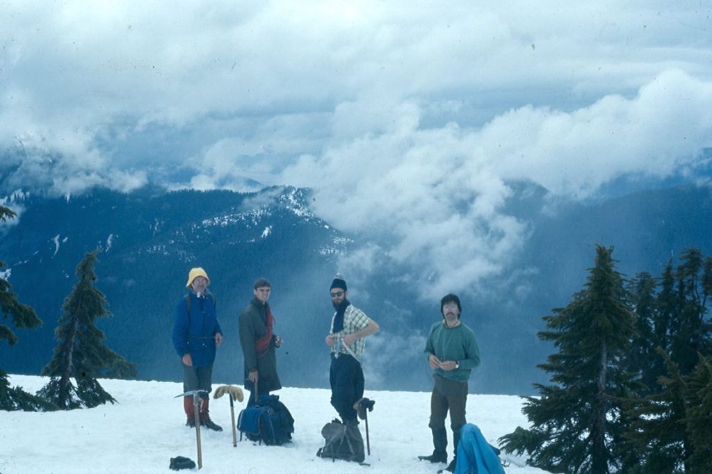
June – Bill Perry, Joe Bajan and Mike Walsh led a party to Mt. Maitland [Hidden Peak] and climb several pinnacles along the ridge including The Banana.
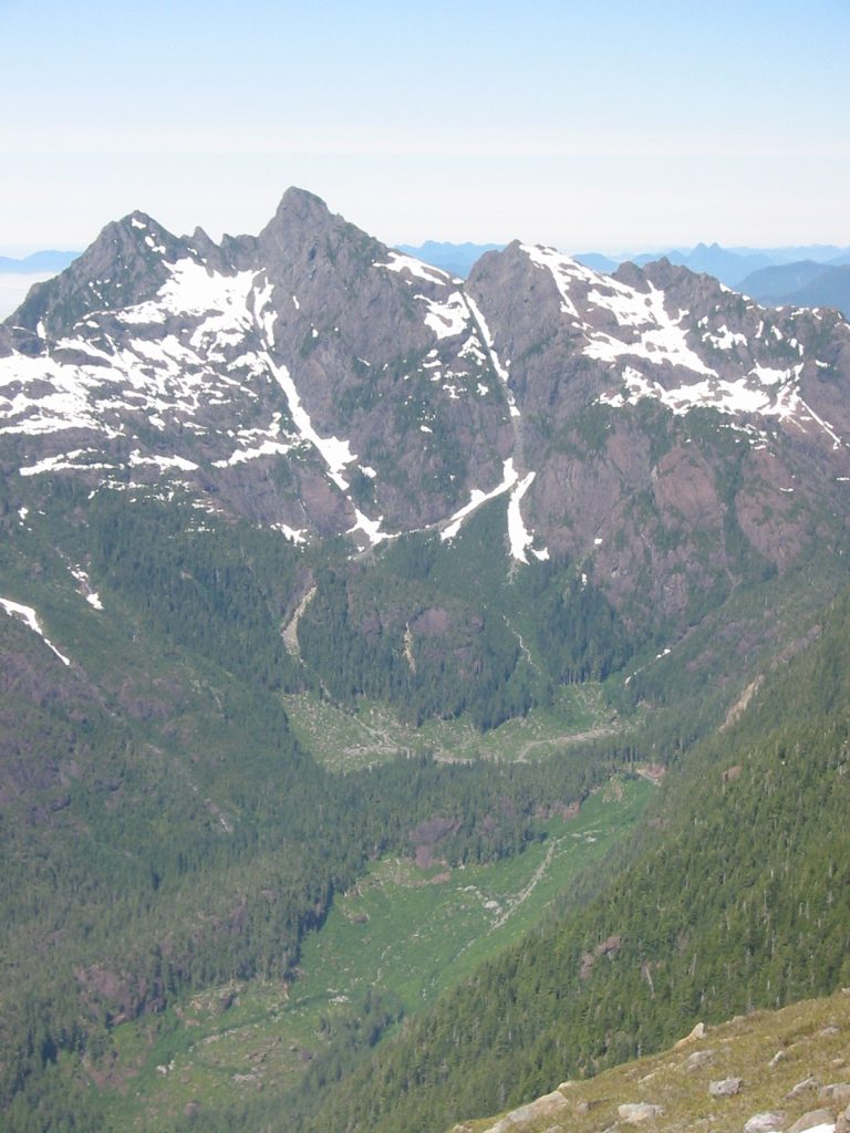
July – Syd Watts and John Gibson make the 1st ascent of a peak they name Watchtower Peak.
July – Mike Walsh completes the first north-south traverse of Rambler Peak.
July 19/20 – Scheduled trip to Shepherds Creek Ridge.
July 19-August 5 – A party of IMR fly into the Plummer Hut near Mt. Waddington and climb a number of peaks.
July – Rick Hudson led an expedition to East Greenland (Angmagssalik region) with Stu Allen, Rob Rowlands, Steve Dawson (New Zealand), Jo and Simonne Straker, and Phee Hudson. A number of peaks were climbed including the first ascent of Neruniartuaraq Peak. (see R.D. Hoare. “Greenland Ho Again. An account of boating and climbing in the Angmagssalik area, East Greenland.” MCSA Journal 1975, Vol. 78: pg. 25-33.)
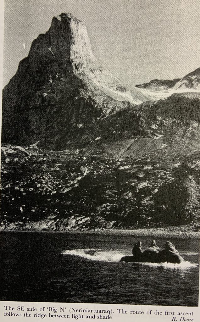
The southeast ridge of ‘Big N’ (Neriniartuaraq). The route of the first ascent follows the ridge between light and shade – Rick Hudson photo.
July/August – Ralph Hutchinson, Mike Walsh and Joe Bajan climb in the Koh-I-Baba region of Afghanistan and make several 1st ascents.
August 2/3/4 – Scheduled trip to Mt. Micthell and Augerpoint Mtn.
August 12-15 – Rick Eppler, John Gibson, Walter Latter, Steve McConnell, John Simpson, Syd Watts climb Rugged Mtn. from the Nomash River.
August 30-September 1 – Scheduled trip to Malaspina Peak.
September 20/21 – Scheduled trip to Mt. Myra. September – Tribute to the late C. Frank Mosely.
October 11-13 – Scheduled trip to the Comox Glacier.
November – Wine and Cheese party at Gil Parker’s with slides of Afghanistan from Joe Bajan, Mike Walsh and Ralph Hutchison.
November 15/16 – Section members spent the weekend at the Mt. Baker ski area.
December 14 – Diane Erickson led a trip to Mt. Cokely.
Section Fees:
$4.00 for Section Member
$3.00 for Life Member
Late 1974, the section was advised that donated funds might be available to finance a hut for Vancouver Island. John Gibson, then Chairman, made enquires regarding sites in the Schoen-Sutton area, and in Strathcona Park including Cream Lake at the south end of Buttle Lake. A discussion about the hut has come up from year to year in the Section and with the pro’s and con’s debated. It would appear that ski mountaineering or cross-country skiing would give rise to the greatest use of a hut, when tent camping is uncomfortable for extended periods. At the same time, a cabin would be a base for summer climbing and hiking. Any site would have to be far enough to permit winter access. The Executive felt that these requirements were fulfilled by Cream Lake, and accordingly the 1975 Executive pursued this site in negotiations with the Parks Branch. Mining claims blanket the area, but it is felt that the focus of recreation activity which a cabin would bring would help balance the mining value of the area and perhaps swing the ultimate land use to wilderness recreation. After several meetings, the Parks Branch agreed to the hut and specified dismountable, panel construction in case any need to move it developed. Moreover, they agreed to pay for helicopter movement of materials to the site, a substantial part of the project cost. In the same week we received the sad news that the donated funds were not available. Since this occurred the week before the Board meeting in Vancouver, I submitted the problem to the Board. While no design or cost had been worked out, the reception by the Board was enthusiastic and I was requested to make a proposal including all facets. While it was not possible for the Board to grant an Approval in Principle, I feel that they would consider a contribution from the Hut Fund. This will depend upon our projected budget and our assessment of the environmental factors and expected uses. While these ideas will require exploration in depth, the considerations now appear as follows:
Disadvantages:
- Possible concentration of people causing environmental damage.
- Ownership by Parks Branch and control of use by them. (It is probable that we would make a trip in the fall to ready the hut for winter use)
- The labour involved in constructing the hut.
Advantages:
- Use by Club members and others especially for winter activities.
- Establish the “recreational use claim” on this beautiful and remote area, midway between Buttle Lake and the Drinkwater Valley (Della Falls and Great Central Lake)
Considering all these factors, I feel that we should proceed with the planning and a proposal to the Board. A site reconnaissance, planning to the proposal, and the actual construction of the hut will require a lot of work. If you have any opinions on whether or not we should take this on, (and are willing to back up a yes vote with a lot of work), we want to hear from you at the Annual Dinner Meeting.
Gil Parker, Section Chairman
The Section receives an invitation from the Mountaineering Federation of the USSR for the following: Camp Pamir – an international alpine camp located in the Pamirs in the region of the 7,134m Lenin Peak, for high altitude climbers. Camp Bezengi – a new camp in the central Caucasus Mountains for those with experience on technically difficult routes.
First Ascent of Hidden Peak
June 7, 1975
By Bill Perry
What I called Maitland Summit is the highest of a group of peaks connected by a long, v-shaped ridge, just north of Kennedy Lake. A lower peak at the south end of the ridge, elevation 3907 feet is called Mount Maitland on the topo map. A group of 11 Island Mountain Ramblers made what is, as far as I know, the first recorded ascent of Maitland Summit. We ascended from the south, having driven to the head of the Sand River valley. No technical difficulties were encountered; it is essentially a scramble, though a highly enjoyable one. An early start is advisable if done as a day trip. No evidence of previous visitors to the summit was observed. Mike Walsh and Joe Bajan scaled an impressive pinnacle near the summit, which they dubbed “The Banana.”
Participants: Bill Perry, Bob Tustin, Mike Walsh, Margaret Symon, Mary Spoke, Clarence de Belle, Bruce McInnes, Fred Put, Dave Coombes, Ed Moi, Joe Bajan.
Addendum:
In 1941, George Jackson and Robert McCaw, both B.C. land surveyors, were working in the Alberni-Tofino area and set up a station on one of the ridges near the peak but didn’t go to the highest summit. The name Maitland Summit was originally submitted by the Vancouver Island section of Alpine Club of Canada because it is the apex of the Maitland Range, but it was resubmitted (by Rick Eppler) as Hidden Peak on 23 September 1985, because the summit of the mountain is hidden by ridges. It was adopted in 1986.
… Waddington …
July 19 – August 5, 1975.
Reported in The Timberline Tales of the Island Mountain Rambler. p.39-40.
By Margaret Symon
“Waddington” was BIG mountains, fantastic granite, yellow, orange, and lime-green lichens, falling in crevasses, sunburn, howling blizzards, 100-pound packsacks, a near plane crash, trundling, desertion at a rainy mosquito-infested wilderness lake. Our 7 a.m. departure from Campbell River on July 19 was delayed by low clouds in the mountains to a late afternoon takeoff. Now with flight up Butte Inlet and the Homathko River took us into the heart of the Coast Range. We landed at Ephemeron Lake at the base of the Tellot Glacier, and camp the first night on the shores of its icy, green waters, our tents pitched midst dwarf fireweed and yellow monkey-flower. Sunday was a long day. Half of the party got an early start for the trek up the Tellot. We travelled at first along a moraine ridge where we found whitebark pine, ainiea, draba, and pink pussytoes. On the sharp rocks we spotted clumps of white hair belonging to mountain goats. We made good time going up the ablation zone of the glacier, for the surface was compacted ice, but shortly we were mushing our way through soft snow. The prospect of falling into crevasses soon caused us to rope up, but despite this precaution, John was the first of the group to drop down a crevasse. We found our airdrop boxes on the second snowfield. The boxes were mostly intact, but we discovered macaroni, milk powder, and (ha, ha!)-wine-do not drop well. The snow was drunk on wine, and much snow sucking took place. Unaware of the proper route and the location of the Plummer Memorial Hut we climbed the last and steepest icefall by moonlight, and finally reached the hut at midnight. In the next few days, the rest of the group made it to the hut, airdrops were retrieved, and some climbing was done. Descriptions of peaks and heights in the Guidebook were confusing, but it is thought that Mt. Shand (3069m), Mt. McCormick (3090m), Mt. Argiewicz (2456m), and Termination were climbed. Al Harrison led some of the more difficult routes, and he, Dave, and Margaret did Claw Peak, which looks down at the hut, a lesser Claw was also scaled. Our first storm blew in on the 23rd, and we were cabin bound for several days. Ray, John, and Bob moved in when their tents ripped apart in 80 mile per hour winds. Besides the nine of us, there were also two brothers from Edmonton, who had hiked in from the end of the road. An account in the Alpine Journal led them to believe that they were in for a four-day trip. Ten days later they arrived at the hut in a state of glassy-eyed starvation. They spent the day after their arrival cooking up concoctions and eating and eating and eating. The storm lifted a while on Saturday and we headed for Heartstone Peak. The day was sunny but there were terrific winds. While climbing we witnessed a flying spectacle. An Otter carrying the Alpine Club flew past the Claw to do an airdrop. The plane, going at high speed, hopped onto the snowfield, jumped several crevasses, and lost a crucial part of its wing, dented its pontoons, nearly ruptured the fuel tank, and deposited a hatch door down a crevasse. One of the Alpine Club members suffered a broken ankle. The plane was considered a write off with $80,000 worth of damage. When the Alpine Club arrived at the Hut they found their airdrop box contents scattered all over the snow (although dried fruit had been cleaned up by the scavenging Ramblers). The whole incident was bad luck for the Alpine Club, as they missed several days of good weather. The day they began climbing Mount Waddington, the mountain was socked in. At dawn on the 29th, the Ramblers set off with dreams of climbing Tiedemann and Waddington. The dreams dissolved like clouds in the valleys when melted by the morning sun. The route to Tiedemann was “prohibitively dangerous” 15 years ago, before the glaciers receded. Looking down icy precipices to wild glaciers with names like Cataract Glacier and Chaos Glacier made us decide we could go no further. We had to contend ourselves with climbs in the upper Tellot Peak, and camp was established on the summit of Mt. Argiewicz. Dave was the winner of the Argiewicz trundling contests. Al, Dave, and Margaret boogied around on the Tellot Spires and on Serra 1, which Bob, Ray and Tom had tried the day before. The second party, choosing a different route, was held back by an overhanging, loose rock. Sitting on Serra, the highest Tellot Spire looking tantalizing, and that afternoon Dave and Margaret climbed it. One pitch took an hour. On Friday morning we left Waddington and its neighbors in a whiteout. We retraced our route down the glacier and camped at Nabob Pass for a couple of rainy nights. The greenness of the pass contrasted greatly with the lichen-black rock and blinding snow of the high mountains. Many flowers grew in the wet meadows of Nabob Pass – mountain spires, birdsbeak, dotted saxifrage, partridge foot, arnicas, and mountain daisy. On the 3rd we were due to be picked up at Ghost Lake so we backpacked over Mount Jeffrey in another whiteout, and with several different notions as to where Ghost Lake might be. We found the lake but the plane did not appear so we set up camp. The mosquitoes were delighted. On Monday several Ramblers slept until the rains subsided at one in the afternoon. Despite clear skies the plane did not come. Our food supply was rapidly dwindling. Ray and Tom mixed hot water with gorp and strawberry jam for supper. Our Beaver splashed down on the lake on Tuesday morning; the lake was reported to have been clouded in the day before. We rejoiced in the thought of the “D.I.” being clean and not having to sleep in drippy tents and soggy bags! The plane flew westward to the sea, and a lifetime of mountains disappeared behind us in the grey clouds. Back in Campbell River, we surveyed the damaged Otter. Trans Mountain pilots told us the damage was estimated at $70,000 to the $120,000 plane. The plane was going to be sent back to the factory to be rebuilt. The fact that the Otter could still fly after all that damage says it is surely an unusual plane.
Participants: Bob Tustin, Ray Paine, Brian Johnson, John Laurie, Ton de Groot, Brian Pinch, Al Harrison, Dave Coombes, Margaret Symon.
Man Hurt in Fall
Reported in The Vancouver Sun Monday September 22, 1975. p.16.
NANAIMO A 19-year-old Nanaimo man was rescued by helicopter after he injured himself in a fall Sunday afternoon on nearby Mount DeCosmos. A search and rescue spokesman in Victoria said a helicopter from Comox rescued Joe Bajan after suffering back and leg injuries in a fall. Rough terrain made it impossible for the helicopter to land at the site, the spokesman said, so the injured man was hauled up on a stretcher lowered out of the craft. He is in hospital here.
Cartoon of Joe Bajan
Vancouver Island
Reported in The Canadian Alpine Journal Vol. 59, 1976. p.56/57.
By Gil Parker
In July Syd Watts and John Gibson made a presumed first ascent of an unnamed 5700-foot peak from the headwaters of the White River valley. They hiked in from the end of the logging road and camped at the foot of the southeast ridge of the mountain, which was followed to the summit. The mountain is distinguished by a well-defined summit ridge about half a mile long, with impressive cliffs falling shear on the east side to the valley of the north fork of the White River. The summit is about three miles south of Mount Adam. The ridge rises abruptly between 4500 and 5000 feet and takes on the appearance of a tower from below. In the Sutton Range east of Vernon Camp, this peak is indicative of the excellent climbing available north of Strathcona Park on Vancouver Island. While descending this tower John’s watch unbuckled itself and was lost. Hence the name “Watchtower Peak” will be formally applied. On an attempt on the unclimbed east peak of Mount Cain in the Sutton Range, Gil Parker with Paul and Diane Erickson, reached the west peak, and climbed down into the notch between the two, intending to make a reconnaissance of the east peak for a climb the next day. Unfortunately, Diane was struck by a falling rock which broke three fingers on her right hand, necessitating a somewhat harrowing retreat, followed by a four-hour drive to the nearest hospital at Campbell River. One day climbs were made on Mount Whymper, and on the Shepherd Creek and Rees Ridge areas above Buttle Lake, in Strathcona Park. Regular rock-climbing practices were held weekly in the hills west of Victoria, where the difficult routes of last year were repeated by many climbers, using both free and artificial methods. The ACC Section sponsored jointly with the YMCA a mountaineering course which took participants to the top of Mounts Baker and Arrowsmith, as well as most of the Victoria area rock routes. The piece de resistance was the return to Rugged Mountain (6151’) again this August. A party of six climbed Rugged Mountain from the Nomash Valley, spending three nights on the mountain, with ideal weather all the time (details in separate account). This mountain shows excellent promise for fine rock climbing and general mountaineering with plenty of scope for variation in routes, and for scenery, the Pacific Ocean at its feet. Ski mountaineering is in its ascendancy, commencing with a March ascent of Mount Moriarty by Dave Tansley and Gil Parker, finding the cairn in the center of the blizzard. The conservation interests of the ACC were well represented, the Section presenting briefs to the Pearce Commission of Forestry Resources in BC, and the hearings of the Schoen-Tsitika area. It is hoped that the strong representations from the various environment conscious groups will preserve some parts of this beautiful and as yet unlogged valley in northern Vancouver Island. The interest in a mountain cabin at Cream Lake south of Buttle Lake got some support this fall, as communication from both the Parks and Mining Departments of the BC Governments indicated that they felt mining activity at the site is unlikely. The financial and moral support of local clubs has been sought with the hope of establishing the recreational use potential of this area.
By Bob Tustin
Most people did their climbing off the island in 1975. There are two notable climbs worth mentioning. Mike Walsh did a solo traverse from north to South of Rambler Peak. The first ascent of the north ridge was a mixture of scrambling, a few 5.3 pitches and one 80-foot 5.5 climb. Exposure and sound rock make this a recommended climb. In June, a large group of Island Mountain Ramblers led by Bill Perry did a successful first ascent of the highest peak in the Maitland Range [Hidden Peak] on the West Coast of Vancouver Island via Woodfern Lake. The same day Joe Bajan and Mike Walsh climbed three major pinnacles near the summit [the first is known as “The Banana”]. The climbing was mainly 5.6 on good solid rock. Only one accident to report. Joe Bajan required helicopter evacuation after falling on Mount De Cosmos while solo climbing. Injuries were minor. Helicopters were used many times by cross country skiers. Marble Meadows is now competing with Forbidden Plateau as being the dream world for cross country skiers. Caves are being discovered in the alpine areas of Strathcona Park. One cave may be one of the world’s ten deepest [Q5 on White Ridge]. Island mountaineers have suddenly become cave explorers. There are still lots of areas to explore and new routes to be done. In 1975, most people were content to climb their favorite mountains by old routes. Next year, we will get back to exploring.
Rugged Mtn
By John Gibson
The long, serrated ridge of the Haihte Range, culminating in Rugged Mountain (6151’), rises behind Tahsis and Zeballos on the West Coast of Vancouver Island, and is a conspicuous landmark from offshore. For years I [John Gibson] had thus admired it from afar, and first visited it in 1974, approaching from Woss Lake on the landward side of the range. On that occasion we spent so long on the lower slopes that we lacked the time to climb the mountain (CAJ 1975, p.66), but that trip whetted our appetites for another visit. This time we decided to approach from the southwest, or seaward side of the range, and on 12 August 1975 a group of six Vancouver Island Section members parked cars beside the road about four miles short of Zeballos, where the old logging road up the Nomash valley branched off (altitude about 350 feet). The bridge was washed out so we started by fording the river, then followed the old road for about four and a half miles until it ended in an impenetrable jungle of dense young growth mixed with old logging slash. We backtracked to a side creek, which conveniently went underground a few yards below the road, and followed its dry bed down to the Nomash River in our valley bottom. The Nomash was also running underground at this point and its dry bed provided a good route up the valley to the end of the logged off area, where it became a healthy torrent again. By a strange coincidence the water just dived underground as soon as it reached the logged off country! In the timber we picked up an old prospector’s trail leading up the valley and followed it as far as the base of a side ridge leading up toward Rugged Mountain. The bush was typical West Coast jungle at first, and slow going, but it improved after the first 1000 feet, and we camped for the night in the timber at 2000 feet. Next morning (13 August) we packed on up our ridge to a pleasant spot at 4500 feet, above timber, where we decided to leave our packs and make camp. After lunch five of us set off for the summit, leaving one to rest and camp after a somewhat strenuous introduction to packing. Traversing right from our ridge we made for the lowest col on the main ridge, west of the summit of Rugged Mountain. We roped on the col at 3 p.m., and walked up the upper glacier on the north side of the peak to gain its east ridge. This gave very pleasant rock climbing, not technically difficult but spectacularly exposed in places (if you like numbers, I’d plump for three) and always interesting, for this ridge kept us guessing what surprises would be around each corner. However, cracks, chimneys, ledges and climbable slabs all presented themselves when needed and we reached the summit at 5.45 p.m. Though Rugged has been climbed more than once we knew no details of previous routes taken, of which ours would certainly be the easiest. We stayed on the top for a little more than half an hour, soaking up the view. To the west, against the evening light, ridge upon ridge was silhouetted against each other in numerous shades of blue-grey-purple, and beyond them the Pacific. Eastwards we picked out many old friends in the centre of Vancouver Island, and beyond them the Coast Range, with Mount Waddington aloofly remote on the far horizon. We descended by the same route, with minor variations, and unroped at the col at 9 p.m., reaching camp at 9:30. It was a cloudless night, and we cook supper by moonlight. Later, as we lay in our sleeping bags, those who had decided not to put up tents were rewarded with a fine display of meteors and satellites chasing across the starry sky. By a lucky chance 13 August is apparently the night of the year for meteors and we couldn’t have chosen a better place for the display. Next morning a leisurely stroll to another col and a minor point on the main ridge, with pauses to enjoy the views and the alpine flowers. Back to lunch at our campsite, after which we packed up and started down, pausing to bathe in a beautiful series of small pools at 4000 feet. Then down through the timber and the final dense jungle and in due course we camped on a gravel bar beside the dry bed of the Nomash, again cooking summer supper in the dark. On the morning of the 15th a brisk walk along the old logging road for an hour and a half had us back at the fording place opposite our cars, just as the weather began to show signs of breaking. The notoriously wet West Coast couldn’t have treated us better.
Participants: Rick Eppler, John Gibson, Walter Latter, Steve McConnell, John Simpson, Syd Watts.
1976
ACCVI Executive:
Chair – Gil Parker
Secretary – Doug Wylie
Membership/Treasurer – Dave Tansley
Programs – Paul Erickson
Bushwhacker editor – Cynthia Tansley
Events:
January 11 – Walter Latter led a trip to Service Mtn.
February – Helicopter flight into Marble Meadows approximately $20 per person. Hike out.
February 8 – Rick Eppler, Dave Tansley and Paul Erickson climb Mt. Arrowsmith.
March 7 – Gil Parker led a trip up Mt. Cokely.
March 20/21 – Scheduled booking of the ACC Whistler cabin.
March 26 – The club’s annual banquet was held at the Quamichan Inn in Duncan. Fips Broda showed slides of his trip to Peru that included a new route on Huascaran and an attempt on Alpamayo. $5.50 per person.
April 3-4 – Rick Eppler and Dave Tansley stay at the Whistler cabin and ski up Oboe Summit.
April 9 – Doug Scott gave a slide show at the Newcombe Auditorium. Lecture and discussion illustrated with slides from the recent ascent of the Southwest Face of Mt. Everest. Admission: $2.50, Students and OAP $2.00.
April 17/18 – Paul Turje, John Simpson and Gil Parker visit Cream Lake.
April 27 – Section general meeting at Fred and Edith Maurice’s cabin on Prospect Lake.
May 1-2 – Only two on the club trip – Dave Tansley and Paul Erickson attempt the Castle Towers.
May 22/23/24 – The ski trip to McGillivray Pass was changed to Mt. Myra. To be led by Walter Latter.
June 11/12 – Dave Tansley leads a combined ACC/YW-YMCA basic mountaineering course on Mt. Arrowsmith.
June 17 – Club general meeting at Fred Maurice’s cabin on Prospect Lake. Brush and broom clearing around the lake shore.
June 27 – John Simpson, Doug Wylie, Brian Hart, Cliff Syroid, Brian Boswell, Sharon Harshaw, Mike Sampson and Rick Eppler climb Klitsa Mtn.
July 9 – John Gibson, Steve Hinde, Rick Eppler, Gil Parker, Alan Robinson and Syd Watts make 1st ascent of Tahsis Mtn.
July 10 – John Gibson, Steve Hinde, Rick Eppler, Gil Parker, Alan Robinson and Syd Watts attempt Malaspina Peak.
July 15 – Club meeting at the Maurice’s cabin on Prospect Lake. The film of the 1st ascent of Mt. Logan was shown.
July 24-30 – John Gibson, Syd Watts, Alan Robinson and George Rushworth climb Mt. Ashwood and Maquilla Peak.
August 7/8 – Doug Wyle to lead a trip up Mt. Albert Edward.
August 21/22 – Alan Robinson to lead a trip to Matchlee Mtn.
August – Ralph Hutchinson, Roger Neave, Gil Parker and Jim Craig visit the Stikine Icecap to attempt Noel Peak again.
September 4/5/6 – Syd Watts leads a party of 12 to the Comox Glacier.
September 6 – Charles Rowley, Gil Parker, John Simpson and Rick Eppler climb El Capitan Mtn.
September 11/12 – Paul Erickson to lead a trip to Elkhorn Mtn.
September 24 – General meeting – Mike Sampson and Sharon Harshaw showed slides of a trek to the Annapurna Sanctuary in Nepal where they climbed Rakshi Peak (c5000m).
September 25/26 – Walter Latter to lead a trip to Mt. Myra.
October 9/10/11 – Gil Parker, Cliff Syroid, John Simpson and Rick Eppler climb of Mt. Constance (Olympics).
October 16/17 – Dave Tansley, Rick Eppler and John Simpson climb Castle Towers.
October 29 – Paul and Diane Erickson host a wine and cheese at their home.
November 26 – The Annual General Meeting to be held at the YMCA on Courtney St.
Rick and Phee Hudson drive overland from the UK to India in a VW Kombi. In Pakistan, along with Charles Bangham (UK doctor) and Ian Berkshire, they attempt K7 in the Karakoram but quickly realized they were way out of their league on the peak. (see R.D. Hoare. “Karakoram Inflation.” The Alpine Journal 1978, Vol. 83: pg. 208-210.) Rick and Phee then drive on to India and spent three months climbing and hiking in Kashmir and the Zulu region. Rick climbs Kolahoi Peak (5425m) with Wolfgang Wenzel (Bavarian), and Rick and Phee trek in Kulu (north of Manali) and climb Peak 5792. (see R.D. Hoare. “A Kashmir Interlude: The ascent of Kolahoi Pk, Indian Kashmir.” MCSA Journal 1976, Vol. 79: pg. 25-30; and R.D. Hoare. “Maps and Mts. Climbing in the Kulu Himalaya, India.” MCSA Journal 1976, Vol. 79: pg. 30-39.)
Kolahoi Peak in India’s state of Kashmir.
Section Fees:
$4.00 for Section Member
$3.00 for Life Member
Cream Lake Hut
The Board advised to defer contribution to the Cream Lake Hut project until 1977 at least. During December and January just past, our Section had received moral support from three Island Clubs, monetary contribution from one more, and a rejection from a fifth. The one objecting contended that a hut would attract recreationalists and their mess would be similar to the effect of mining operations in destroying the wilderness attributes of the area. Without reference to the A.C.C. this club advised the Parks Branch and the F.M.C.B.C. Coincident with these negotiations, the B.C. Director of Parks advised us that they were currently conducting a review of the Policy Statements for Strathcona Park and were formulating a policy on mountain huts. The Cream Lake hut has been deferred until this review is completed, probably in May ’76, and our Executive felt that this was too late to allow fund raising and construction in 1976. While the Parks Branch will invite public input to their studies, it is most unfortunate that their officials led our Club so far down the garden path and then underwent what appears to be a complete change of heart. It is hoped that the project is only delayed, and the Cream Lake is not lost to mining, or to a zoning which prevents use of the area by a wide range of mountain travellers.
Gil Parker, Chairman.
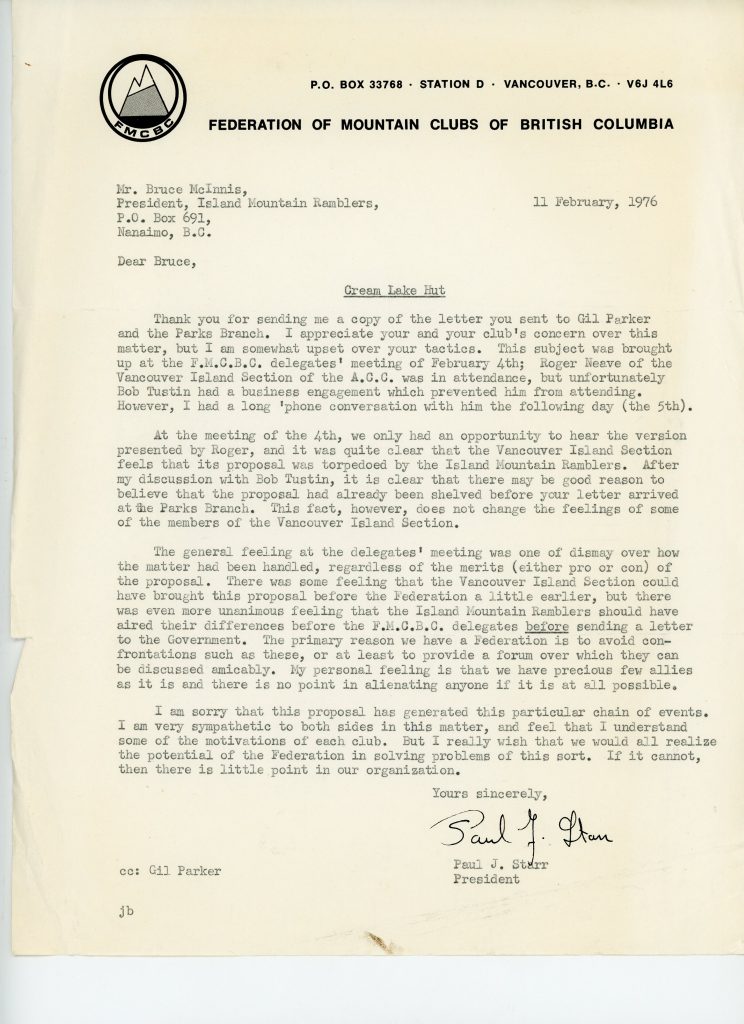
Correspondence from Paul J. Starr, President of the Federation of Mountain Clubs of British Columbia, to Bruce McInnis, regarding the Cream Lake Hut.
Correspondence from Bruce E. McInnis, President, Island Mountain Ramblers, to Gil Parker, Chairman, Vancouver Island Section of the Alpine Club of Canada, regarding the Cream Lake Hut.
Letter sent to Gil Parker and Paul Starr at FMCBC from the Island Mountain Ramblers regarding the proposed Cream Lake Hut by the ACCVI and a response from the FMCBC to the IMR.

Image of an article entitled, “The Trouble with Mountain Huts, published in Mountain Talk, by Bob Tustin.
Strathcona Park (Mines?)
As most of you are aware, there has been a continuing effort to open up Strathcona Park to more mining. At present Western Mines is the only company actively mining a claim in the park. As it appears that there is continuing pressure on the government by owners of other mining claims to allow these claims to be activated. The policy of the former NDP government was to buy back these claims as funds became available under a system of priorities. Whether or not this was a proper course of action is debatable. Of course, there has been a change of government and this policy is now under review. This is where we as an Alpine Club should be most concerned. The whole question may be resolved on the basis of recreational value versus mineral value. This may be a straightforward and valid approach to the majority of people who have no direct interest in the area but unfortunately the determination of these values is impossible to quantify. Let’s look at a specific area which will be the focal point of this issue, Cream Lake. Cream Lake Mines claim that there is $190 million worth of ore on their claim. However, the geology of the area prohibits very precise estimates of the extractable ore. In order to determine whether or not a mine will be economic, more intensive surveys must be carried out which will bring with it some damage to the area. On the other hand, how does one arrive at a dollar value of the or the recreational potential of this area. Vancouver Island is of limited size. The alpine areas are even smaller in scope. Much of the island has been logged. In the years ahead, the existence of untouched alpine areas on the Island will be extremely valuable. Cream Lake in particular is in the center of an area roughly 30 miles square which contains the most beautiful alpine country on the Island. It is also in the center of many hiking trails and ridge routes connecting the mountains from Mount Albert Edward to the Golden Hinde. Most important to this issue is that it is parkland. If one is trying to evaluate multi-use potential of this area, the fact that it is already in a park should put the onus on the nonconforming user, (i.e. the mines) to prove significant public benefits from their intended use. The public benefits and the dollar value of the ore in the ground are not necessarily the same. So, resolving dollar values on both sides of this issue may be very difficult. One more point. Cream Lake Mines feel that fair compensation for this ore would be 10% of $190 million, their expected profit. Based on share value or exploration costs to date this represents a true return of several thousand percent, hardly justified. The whole legal question of these claims remains to be answered. They were granted by Orders in Council, surely they can be removed by Orders in Council. Perhaps a fair settlement would be payment for exploration to date. It may be up to the courts to make the decision. There will be more news on this issue. The Sierra Club is preparing a campaign to preserve this area for recreation only. We have offered to lend our support to them. If anyone would like to know more about this issue, or offer any assistance or ideas, please contact the executive.
Doug Wylie
Treasurer’s Statement
Receipts:
Opening balance 413.20
Section dues 169.00
ACC rebates 201.40
Doug Scott evening 1227.25
2010.85
Expenses:
AGM (Empress Hotel) 51.00
Executive expenses 66.46
Annual dinner 46.65
Bushwhacker 63.70
Doug Scott evening 484.28
Section badges 32.50
Donation to ACC Expd. Fund 75.00
Section Waddington trip 100.00
FMBC dues 20.00
Program 12.84
952.43
Closing balance 1058.42
Park Mining Proposed
Reported in The Victoria Daily Times Wednesday February 18, 1976. p.1 & 2.
By Humphry Davy
A B.C. Department of Mines report recommended that one of Vancouver Island’s most spectacular areas be deleted from Strathcona Park, the Victoria Daily Times learned today. The Big Interior Mountain complex includes such attractions as Della Lake and Della Falls – the latter regarded as one of the highest in Canada. Its ridges are nationally known for their acres of heather, profusion of alpine flowers, glacier moraine, ice field and Beauty Lake. The complex also offers a spectacular view of surrounding peaks in the 302,000-acre park. The report, entitled Mineral Resources Considerations, states that the summit ridge of Big Interior Mountain is a barren, windswept feature which is neither “beautiful nor spectacular and is surpassed in grandeur by many other mountains.” Mine Minister Thomas Waterland has not yet been presented with the report. He was tied up today at an orientation course for freshman MLA’s and was not available for comment. Three weeks ago Waterland said mining in parks “isn’t a bad thing” if strict environmental controls are enforced. He said he was not announcing government policy and that it was his own opinion. Deletion of the alpine region from the park would permit exploration for copper and other mineral deposits on eight crown-granted claims, the report states. But explorer Syd Watts, a member of the Alpine Club of Canada, said the mine department must be viewing Big Interior Mountain “through smoked glasses. It’s absolutely ridiculous,” he was quoted as saying of the report. “It is also a splendid area for skiing.” Watts observed that when the Bedwell Creek was deleted from Strathcona Park the government said it was of little value because it was situated in a rain forest. “So is Olympic National Park in Washington situated in a rain forest area,” he said, “but thousands of people from all parts of North America visit the park. That doesn’t deter them. “It is also ridiculous to say the summit is windswept,” he added. “What peak on Vancouver Island is not windswept?” Watts said the Alpine Club of Canada is assembling a collection of coloured slides of the area to show people what the province would lose if the mountain was deleted from the park. Brian Pinch, a director of the Sierra Club who has read the mining report, said once the mountain is excluded from the park, it would be difficult to exert controls on mining operations. “This is a very beautiful area,” he said. “The club feels the mining department reasons leading to its recommendations are faulty.” The previous Social Credit government practiced the policy of multi-purpose use of parkland – for mining and forestry in addition to recreation purposes. The practice led to opposition from conservationists over dumping of sewage and mine tailings, including heavy amounts of poisons such as lead and arsenic into lakes and streams. Under the NDP government, a policy stopped new mining claims being filed in provincial parks and stated that dormant claims could not be worked. Big Interior Mountain is situated near the south boundary of the park. It is accessible via Great Central Lake and an old logging road skirting Drinkwater Creek which ends at the foot of Della Falls. Hundreds of people during the late summer months hike to Della Falls, a three-hour walk from Great Central Lake. A pathway runs up to the alpine ridge of the mountain where there are trails through the alpine meadows to Della Lake and Beauty Lake.
History Of The You Creek Mining Claims
By Lindsay Elms
Since the establishment of Strathcona Provincial Park in 1911, mining within its boundaries has been a controversial issue. Unfortunately, some of the mining claims have certain exemptions under the Parks Act. One such group of claims is the You Group made up claims known as Ex, Ten, You and Eight. They were staked in the You Creek watershed in Strathcona’s southern area. The group is located on the southwest slopes of Big Interior Mountain above You Creek, one of the largest tributaries of the Bedwell River. The gold-bearing quartz vein was first located in 1912. Between 1915 and 1919 John D. McLeod undertook some work on the property. The You Group claims are located between 1800 and 2200 feet in elevation, and the quartz vein is in a three-foot shear in granodiorite, the predominant rock on the lower forested slopes of the mountain. This is quite different from the conspicuous thick limestone cap found on the summit of Big Interior Mountain where the copper-rich Ptarmigan Group of mining claims is located. In 1921, William M. Brewer a mining engineer, visited the You Group at the request of the new property owner J.B. Woodworth of Vancouver, and wrote the following description:
The fissure is exposed in a narrow gulch, the effects of erosion, for a vertical height of about 500 feet above the trail, where an adit [an adit (from Latin aditus, entrance) is a horizontal passage to an underground mine] is driven along a strike of the vein in a northeasterly direction. Owing to the quantity of water flowing down the gulch no close examination could be made of the vein above the adit on the trail. The fissure, with similar filling, has been traced down the mountain side a distance of 500 feet below the trail, where it has been exposed in open-cuts.
That same year (1921) the claims became crown-grants. In a report to the Minister of Mines in 1922 it was stated that “facilities for milling and concentrating could hardly be excelled, for the reason that Bedwell River can be developed to furnish all the water-power necessary to drive all machinery, as well as for concentrating purposes.” Unfortunately, the spring of 1922 was a heavy snowfall season which hampered Woodworth’s efforts. His cabin on the property was also destroyed by fire at the time he was ready to build the small quartz-mill he had packed onto the property. By 1923, the small homemade cyanide mill was installed and operational, however, no figures on its production are available but remains suggest a capacity of five to ten tons per day. In 1932, J.B. Woodworth returned with a small crew, and worked for a couple of months rebuilding the old camp, reconditioning the mill and driving an adit-drift three hundred and thirty-seven feet into the vein. Test runs showed that recoveries could be made by concentrating and cyaniding the ore and it was estimated that sufficient tonnage was available to make the property a profitable producer. Further samples were taken but by 1933 it was realized that the lack of transportation facilities was going to handicap the mine’s production and it eventually was abandoned. In 1940, Bralorne Mines Ltd. inspected the property for John D. McLeod. McLeod had regained the property after Woodworth’s ownership lapsed. In the conclusion from the Bralorne Mines report they wrote:
The quartz vein has been exposed by 340 feet of drifting disclosing a total of 1,470 tons of probable ore averaging 1.36 oz. per ton after allowing for 20% dilution in mining and a mill recovery of 95%. With a capital outlay of $65,400 deemed sufficient to bring the property into production 1,790 tons of ore would be required to return this capital, judging the profit per ton as $36.50. The amount of additional ore required, 320 tons, seems well within the limits of the geological possibilities of the ground. Assuming the present lengths of ore disclosed and the profit yielded by this ore per vertical foot of depth ($496) carried to a vertical depth of 500 feet, then the profit would be $248,000. The life of the mine on a 25 Ton per day basis required to realize this profit would be less than one year (272 days). Such a profit is exclusive of possibilities in the lateral extension of the present veins or in the discovery of parallel veins.
The property was again subjected to a thorough, although localized, examination by Ridgeway R. Wilson and Associates, a mining engineer firm in December 1944. The company’s conclusion was:
This crown granted group has sufficient ore of the usual narrow, high grade Vancouver Island – Zeballos type, to warrant further development of the two presently exposed shoots as well as the limited exploration of a newly discovered shoot.
It went on to recommend that combined development of at least three adjacent properties would help reduce initial and operating overhead expenditure: cost of mill, road construction, power and mine management. In their summation they said:
Obviously, almost any ore deposit on Vancouver Island may be rapidly and cheaply brought to production relative to those located in the interior of B.C. Specifically, the You Group is about five miles from a truck road. The proposed initial development would require only a pack horse trail and hand mining. It is estimated that six months work with a crew of six (one packer, one cook and four miners) would repair the camp, the trail, and ascertain the vertical continuity of the known ore shoots at an overall cost of less than $20,000 (600’ to 1,000’ of drifting). Hand mining would approximate $15 per foot (direct expense).
Calculations estimated one shoot could be relied upon to supply at least 2,625 tons of .88 oz. grade probable ore with a value of $80,850 [1945 prices]. Another shoot would possibly produce 2,628 tons of .86 oz. grade with a value of $79,102 (at $35/oz). Assuming, conservatively, that operating costs would not exceed $15 per ton, the operating profits would amount to $81,172 for both shoots and it was quite possible that the shoots could supply enough ore to show a profit of about $110,000 depending upon ore shoot boundaries. In January 1945, when this report from Ridgeway R. Wilson and Associates was released, gold was valued at $38.50 per oz. Unfortunately, no further work was undertaken on the property until 1960 when Tanar Gold Mines Ltd. of Vancouver stripped and test pitted the main vein to an extent of 4,100 feet on the surface. In 1961, Harvey H. Cohen, a mining engineer and Roger Verity of Tanar Gold Mines Ltd. inspected the property and wrote a favourable report but again very little work was continued with the property. Sometime in the 1980’s Kilo Gold Mines Ltd. of Alberta obtained the You Group of claims and in October 1985 the President Thomas E. Kirk reported they were about to start exploration on the property. However, it appears very little was done and since that time the claims have laid idle and a luxuriant layer of moss has slowly begun to grow over everything. Today the old cabins have disintegrated and returned to the forest floor as well as the old homemade cyanide mill. However, the adits still exist and are like doorways into the underworld of the mineral laced mountain. The quartz veins are still exposed along the walls and ceiling of the adits and the gold specks continue to sparkle when light shines upon it, allowing the viewer to dream of riches derived from the hunt for gold.
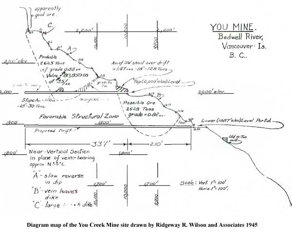
Diagram map of the You Creek Mine site drawn by Ridgeway R. Wilson and Associates 1945.
Cut Out Spectacular Area?
Reported in The Daily Colonist Thursday February 19, 1976. p.13.
Mystification appeared to be the only reaction of Deputy Mine Minister James Fyles to the disclosure Wednesday that a mine department report was recommending deletion of one of Vancouver Island’s most spectacular areas from Strathcona Park. The report, titled Mineral Resources Considerations, says that the deletion of the area – Big Interior Mountain district, which includes Della Lake and Della Falls, highest waterfall in Canada – would permit exploration of copper and other mineral deposits on eight crown-granted claims. Fyles expressed amazement at the title of the report. He explained it had been parks department policy since 1973 that there would be no mining in parks, and this had left unsolved various problems with those who held mineral claims. There had been he said, a lot of in-house studies of this problem.” But he added mystified by the report and by the deletion it recommended, which he said was a parks department problem and not one for the mines department. Recreation and environment groups have been quick to react to the report and express their horror. Robert Harris, president of the Victoria Fish and Games Protective Association, said his group was opposed “taking any section out of any class A park for whatever reason.” He wanted to know what type of mining the department had in mind of the district, and urged that an environmental study be done on the whole area before making any move. Mine Minister Thomas Waterland could not be reached for comment. The minister said three weeks ago that he felt mining in parks wasn’t bad as long as strict environmental controls were enforced. The report says the summit ridge of Big Interior Mountain is a barren windswept feature which is neither “beautiful nor spectacular and is surpassed in grandeur by many other mountains.” But explorer Syd Watts, a member of the Alpine Club of Canada, said the mine department must be viewing Big Interior Mountain “through smoked glasses. It’s absolutely ridiculous,” he was quoted as saying of the report. “It is also a splendid area for skiing.”
A Park Is A Park Is …
Reported in The Victoria Daily Times Friday February 20, 1976. p.4.
No decisions have been made yet, but Mine Minister Thomas Waterland’s recent comments (mining in parks “isn’t a bad thing”) and a mines department report urging deletion from Strathcona Park of a spectacularly beautiful alpine area called Big Interior Mountain are alarming warning signs. There is also before the mines department an application by Cream Silver Mines Ltd (which has a working arrangement with Western Mines) to operate a mine in the Cream Lake area of the park, also in the southern part, which the Sierra Club opposes. While Western mines is situated on claims staked more than sixty years ago (and thus might be considered to have prior rights in the park), these new proposals are on particularly shaky ground. Non of the claims in the southern part of the park date from before 1964, many of them as recent as 1970. The New Democratic Party did some stupid things, but its parks policy wasn’t one of them. Adding millions of acres of new parks, and enshrining them in legislation (which only legislation may alter, not cabinet) with the existing ones, putting an end to claim-staking in provincial parks – these were actions which met with widespread approval, and probably still do, regardless of what happened on December 11 last year. Vancouver Islanders, particularly, remember the broken promises over the Western Mines operation. We were first told that no tailings would go into Buttle Lake, then when that was reversed, the company said the tailings wouldn’t pollute the lake. Then came research reports from independent scientists showing that heavy metal levels in the water and in the fish in the lake had risen drastically. Lead content in fish between 1966 and 1969 rose by up to 1000 per cent. The pollution levels now in Buttle Lake – upon which Campbell River depends for its water supply – may not be lethal, but then half a century ago nobody thought twice about pulp mills dumping mercury wastes into river systems either. To be fair, the mines department report quoted in the Times on Wednesday, recommends the protection of Della Lake and spectacular Della Falls, not their deletion, but these two beauty spots are very close to the group of eight mining claims on Big Interior Mountain, (within two miles in fact) and it may be exceedingly difficult to preserve them once the mining companies go in. If a mine is developed there, more than the mere two-thirds of a square mile comprising the actual claims will be required. The mining claims are at a higher elevation than the lake and the falls. To get there, a road may have to go right through the area recommended for protection. And what happens to the mine waste? And Big Interior Mountain is not the only area of the scenic southern part of Strathcona Park which is threatened. There is the aforementioned Cream Silver Mines Ltd., application to operate a mine at Cream Lake only three miles north of Della Falls. Other claims exist at Beauty Lake, a mile south of the falls. Mistakes by former administrations-seen today in hindsight-allowed these claims to be staked. A certain legal entitlement goes along with these claims. But it’s a problem that can be surmounted, by outright purchase, or trades, by one means or another. We believe as the Sierra Club does, that the time has come to draw the line.
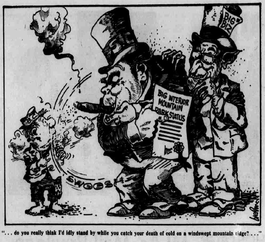
“… do you really think I’d idly stand by while you catch your death of cold on a windswept mountain ridge? … ”
Strathcona Park
Reported in The Victoria Daily Times Wednesday February 25, 1976. p.4.
The Alpine Club of Canada thanks you for your comments of position on the preservation of the south part of Strathcona Park. Your cartoon of February 20 was accurate, but frightening in its depiction of the situation. Of course, some desperate need for resource may predicate extraction of minerals. But have we come to the point where we must open areas of marginal mineralization to mining? Are we a society ready to sacrifice an area such as Della Falls, Big Interior Mountain, and Cream Lake to the degradation which unavoidably follows mining? We strongly suggest that we are not! We are completely in sympathy with the stand of the Sierra Club in this issue. The report 1400 annual visitors hiking through the Marble Meadows sector of the park gives a minute indication of the need for future parkland. We feel that the provincial government has a duty to her citizens not to give in to short term balance of budget pressures, and not to yield this valuable and beautiful part of the park.
Gil Parker, Chairman of the Vancouver Island Section of the Alpine Club of Canada.
Mt. Tom Taylor
Reported in The Daily Colonist (The Islander section) Sunday March 7, 1976. p.1.
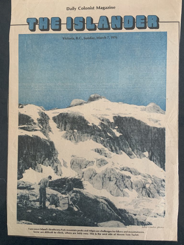
Vancouver Island’s Strathcona Park mountain peaks and ridges are challenges for hikers and mountaineers. Some are difficult to climb, others are fairly easy. This is the west side of Mount Tom Taylor.
Mining Ban In Park Endorsed
Reported in The Victoria Daily Times Monday March 8, 1976. p.2.
A resolution urging the provincial government to continue the policy of disallowing mining in provincial parks was unanimously endorsed at a regional meeting of the Federation of B.C. Naturalists of Vancouver Island held at Nanaimo Saturday. Representatives of eight societies, including Thetis Park Nature Sanctuary Association and Victoria Natural History Society were present. The resolution specifically mentioned an application by Cream Silver Mines Ltd. for permission to carry out mining operation at Cream Lake, one of the more picturesque sub-alpine areas in Strathcona Park. Bob Dickhous, president of the Thetis Park Nature Sanctuary Association, said delegates were also concerned with a mining report recommending that the Big Interior Mountain system be deleted from the park. The mountain’s main attraction are its alpine meadows and Della Falls, one of the highest in Canada. The delegates also urged that the boundaries of the Strathcona Park be revised to include the Gold Lake area, the narrows of the north end of Buttle Lake which includes the campsite and the northwest end of Great Central Lake. Mrs. Dulcie-Hamilton, president of the Comox-Strathcona Natural History Society, said the additions should be made to make up for the damage done to the park in the past by logging, mining, hydro power projects and timber trades. The meeting also endorsed a resolution calling on both federal and provincial governments to co-operate in enacting legislation for sea coast protection. It also urged the government to extend the mandate of the Islands Trust and to strengthen its powers to make it more effective. The delegates noted that existing controls on logging companies which own large sections of the islands, is inadequate.
Island Girls Crushed by Giant Fir
Reported in The Daily Colonist Tuesday August 4, 1976. p.1.
CAMPBELL RIVER-Two Campbell River girls were crushed to death Monday night when a seemingly healthy 150-foot Douglas fir toppled on their tent as they lay sleeping in the Ralph River campsite on Buttle Lake in Strathcona Park. Laurie Jean Primrose, 11, and her companion Tracey Lee Deakins, 9, were lying in their tent about 15 yards from a trailer occupied by Mr. and Mrs. Lorne Primrose when the tragedy struck. Tracey, the daughter of Mr. and Mrs. Fred Deakins of Campbell River, had joined the primroses for the holiday trip. The Deakins have two other children, Cindy, 12, and Kerry, 3. It was not known whether the Primrose family have any other children. According to one witness the six-foot diameter tree came down about 10 p.m. with a “rifle crack” sound and the girls were struck by a section 60-feet from the tree base. A Campbell River RCMP spokesman said Strathcona Park employees attended equipped with power saws and helped campers at the site remove the tree section from the top of the tent. The victims were pronounced dead at the scene. Parks superintendent Gordon Rathbone said Tuesday the accident was “freakish” as there was no wind at the time. “It was thoroughly breezy in the afternoon but the wind had died down and it was very calm last night,” he said. Rathbone said the tree, which he described as over-mature timber, was upended at the roots when it fell. “The rot went right down to the roots,” he said, adding the extensive rot was probably the cause. The parks branch had conducted a snag removal program at the campsite last November, felling about 50 dangerous trees, he said. However, the fallen fir had green branches and showed no evidence of rot. He said the campsite was set in an overmature stand of trees and that the parks branch was constantly watching out for trees which were leaning or which pose a danger to campers. He cautioned that there was “an inherent danger” in camping among huge trees, but indicated there was little that could be done beyond the branch’s snag program. Parks employees worked through most of the night cutting up the tree which blocked the main road to the campsite, he said, but the bulk of the tree would remain until the parks branch continued its snag program later this year. Rathbone said it was the first incident he knew of in which anyone had been killed by a tree at a campsite, although there had been reports of “near misses.” The Colonist contacted a parks employee at the Strathcona Park headquarters Tuesday morning but he spokesman said “no one here wants to talk about it.”
Malaspina Peak Attempt
From personal communication with John Gibson and Syd Watts to Lindsay Elms.
On July 9, 1976, John Gibson, Steve Hinde, Rick Eppler, Gil Parker, Alan Robinson and Syd Watts climb Tahsis Mountain. That evening they parked their vehicles on the Tahsis Road between Malaspina Lake and Perry Lake. The next morning, 10 July, they headed off into an area that had been previously logged. After three hundred feet they crossed a small valley and reached the Northwest Ridge of Malaspina Peak. The ridge rose steadily and according to John Gibson there were no difficulties avoiding the bluffs. Game trails were good and the bush was not as thick as they expected being so close to the West Coast although they got slightly wet in the huckleberries. Eventually they emerged from the timber onto an open snow-covered ridge at 3500 feet and followed the ridge towards the south peak. Roping up they traversed left up fairly steep snow to a col between the south and main summits. The main peak was hidden by cloud and separated from them by “some rather fearsome looking gendarmes.” Consequently, the route to the main peak looked a bit complex for such misty conditions and they decided to settle for the south summit which looked more approachable with a straight forward snow ridge leading to it from the col. Upon reaching the mist shrouded summit around 2 p.m. they found a substantial cairn adorning it with no indication of who had built it. On the way down the main summit briefly revealed itself through a rift in the clouds and “it looked a forbidding looking rock tower of impressive verticality.” Later in the day the weather cleared altogether and it looked as though a traverse around the rock tower would lead to an easier approach to the main summit from the north.
Vancouver Island Section
Reported in the Canadian Alpine Journal Vol. 60, 1977. p.61.
By Doug Wylie
1976 was another year of varied activities which indicated a healthy growing section. One of the highlights of the year was the Mount Everest lecture by Doug Scott. A sellout audience was delighted with the tremendous quality of the photographs and Doug’s informative and often humorous discussion. This evening put the Section in excellent financial shape. As a result, we have been able to buy more climbing equipment, send $75 to the Club Expedition Fund, donate $200 to the ACC Pumori Expedition [the first Canadian Himalayan expedition] and help to underwrite a portion of the Section Mount Waddington trip. Our representation on the Federation of Mountain Clubs of B.C. has been continued by Charles Rowley. It is hoped that conservation issues on Vancouver Island may be more properly pursued through this organization. Our Hut at Cream Lake has been postponed indefinitely as the Provincial Government is considering a new zoning regulations within the park. However, the Section, in conjunction with the Sierra Club, continued to press for a halt to further mining in Strathcona Park. This campaign appears to have been successful as Premier Bennett issued a statement in the legislature this summer which outlined Government Policy in this matter – no new mines will be started inside Provincial Parks. The unnamed peak reported in the 1976 CAJ has now been officially named Watchtower Peak by the Canadian Permanent Committee on Geographic Names. In spite of generally bad weather this summer the climbing was very successful. In addition to the old standbys such as the Comox Glacier, Mt. Albert Edward and Elkhorn Mountain, there were trips to Klitsa Mountain (with a 2500-foot glissading descent), Malaspina Peak, and Tahsis Mountain. Off the island there was a successful climb of Mt. Constance in the Olympics, and a week-long expedition to the Mt. Waddington area.
1977
ACCVI executive:
Chair – Walter Latter
Secretary – Alan Robinson
Membership/Treasurer – Dave Tansley
Bushwhacker editor – Mike Sampson
FMCBC rep – Charles Rowley
Program – Paul Erickson
Bushwhacker layout and design by Jim Weston, Artspring Graphic Productions.
Events:
Practice rock-climbing every Tuesday night – contact Rick Eppler for details.
January – Rick Hudson and Greg Moseley attempted the east ridge of Monte San Lorenzo (3706m) on the border between Argentina and Chile in Patagonia. They made a number of ascents of the surrounding peaks including Cerro Hermoso.
Monte San Lorenzo on the border between Chile and Argentina.
January 9 – Scheduled cross country skiing in Cowichan Lake area to be led by Paul Erickson.
January 16 – Scheduled trip to Cottonwood Creek to be led by Walter Latter.
January 22/23 – Scheduled trip to Mt. Baker cross country skiing to be led by Paul Erickson.
January 30 – Scheduled trip to Green Mtn. to be led by John Simpson.
February 10 – General meeting at the YMCA. Slides were shown of Mts. Baker and Shuksan.
February 26 to March 5 – Leadership Training Week – Ski Mountaineering. Cost: $90.00. A $25.00 deposit is required.
March 6 – Scheduled trip to Mt. Cokely to be led by Diane Erickson.
March 19-21 – Scheduled cross country ski trip to Hurricane Ridge to be led by Marek Jarecki.
March – The annual banquet dinner at the Quamichan Inn in Duncan. Paul Starr gave a slide show on his ascent of The Cat’s Ears and Devil’s Thumb, two striking mountains in the Stikine Icecap with Fred Douglas and Dick Culbert.
The Cat’s Ears and Devil’s Thumb.
April 2/3 – Scheduled trip to Rainbow Mtn. to be led by Dave Tansley.
April 17 – Scheduled trip to the Chemainus Valley area to be led by Gil Parker.
April 30-May 1 – Scheduled trip to Flower Ridge to be led by Charles Rowley.
May 15 – Rick Eppler leads a trip to Mt. Hooper.
May 28/29 – Club trip to Pogo Mtn.
July 1 – Gil Parker leads nine members to the top of Mt. Rainier.
July 6 – Section meeting at the YW-YMCA, 880 Courtney St. Slides of Tahsis Mtn. and Malaspina Peak.
July 16/17 – Club trip to Mt. Cheakamus led by Dave Tansley.
July – John Put and Perry Beckham put up two new routes on Mt. Arrowsmith.
July 18 – Joe Bajan and Peter Busch make the 1st ascent of the North Face of Elkhorn.
July 11-20 – Gil Parker, Ralph Hutchinson, Roger Neave and Jim Craig attempt Noel Peak in the Stikine Icecap area.
Ralph Hutchinson and Roger Neave on Noel Peak – Gil Parker photo
July – Chris Barner and Frank Sommer traverse five summits of Mt. Colonel Foster.
July 26/27 – Perry Beckham and John Put climb Culbert route on the east face of Mt. Colonel Foster.
July 25-28 – Steven Howie and Paul Welle climb Culbert route (slight variation) on the east face of Mt. Colonel Foster.
July 30-August 1 – Club trip to Nine Peaks led by Doug Wylie.
July 30-August 1 – Bill Perry leads a trip to the Mackenzie Range. Tom Emerson, Al Harrison and Bill Perry make 1st ascent of Flat Top.
August 13/14 – John Gibson, Syd Watts, Alan Robinson, Rick Eppler and Geoff Squarok make 1st ascent of Malaspina Peak.
September 3/4/5 – Club trip to Victoria and Warden Peaks led by Paul Erickson.
September 17/18 Walter Latter leads a trip to the Golden Hinde. Fly in to Burman Lake.
November 4 – Wine and Cheese party at the Princess Louise Room at the Empress Hotel. $2 per person. Submissions invited for a new name to the section’s newsletter.
December 17/18 – Club trip to Diamond Head in the Garibaldi area led by Paul Erickson.
1977 Cross Country Ski Tour – Manning Park; Apex Mountain; Silver Star Mountain; 108 Mile Ranch. Eleven days, ten nights tour. Overnight in comfortable motels and lodges; travel in a winterized 12 passenger van; driver /ski guide included.
Sandy Briggs spent two months on a mountaineering expedition to the Umanak (Uummannaq) district, Upernivik Island, Igdlorssuit Sound, with the University of St. Andrews Greenland Expedition.
Sandy Briggs on the summit of Merendi, Upernivik Island, West Greenland 1977 – Sandy Briggs photo.
A two-day Avalanche course intended for persons who are engaged in location work for highways, powerlines, mines, recreational areas, forestry, etc. Location: Rogers Pass. Fee: $25.00
Section Fees:
$4.00 for Section Member
$3.00 for Life Member
Treasurer’s Statement: 1977
Receipts:
Opening balance 1058.42
Main club dues rebate 209.20
Section dues 230.00
Pieps rental 23.00
Refund on ice axes 7.50
1528.12
Expenses:
Bushwhacker 184.46
3 pieps radios 111.85
Wine and cheese party 46.15
Pumori donation 200.00
Membership cards 11.98
Annual dinner 59.50
YM-YWCA coffee 9.00
Membership Chairmans expenses 16.49
FMBC dues 50.00
Returned cheque 4.00
698.43
Closing balance 834.69
Schoen Lake Provincial Park:
The Honourable Sam Bawlf, Minister of Recreation and Conservation announced the establishment of a new 8170-hectare Class “A” provincial park surrounding Schoen Lake on northern Vancouver Island and the addition of 4172 hectares of Strathcona Provincial Park.
Suggested graduating peaks, listed in order of difficulty:
Mount Colonel Foster
Rugged Mountain
Warden Peak
Elkhorn Mountain
The Golden Hinde
Victoria Peak
Nine Peaks
Mount Harmston
Mount Septimus
Mackenzie Range
Reported in Timberline Tales the newsletter of the Island Mountain Ramblers Fall 1979. p.1.
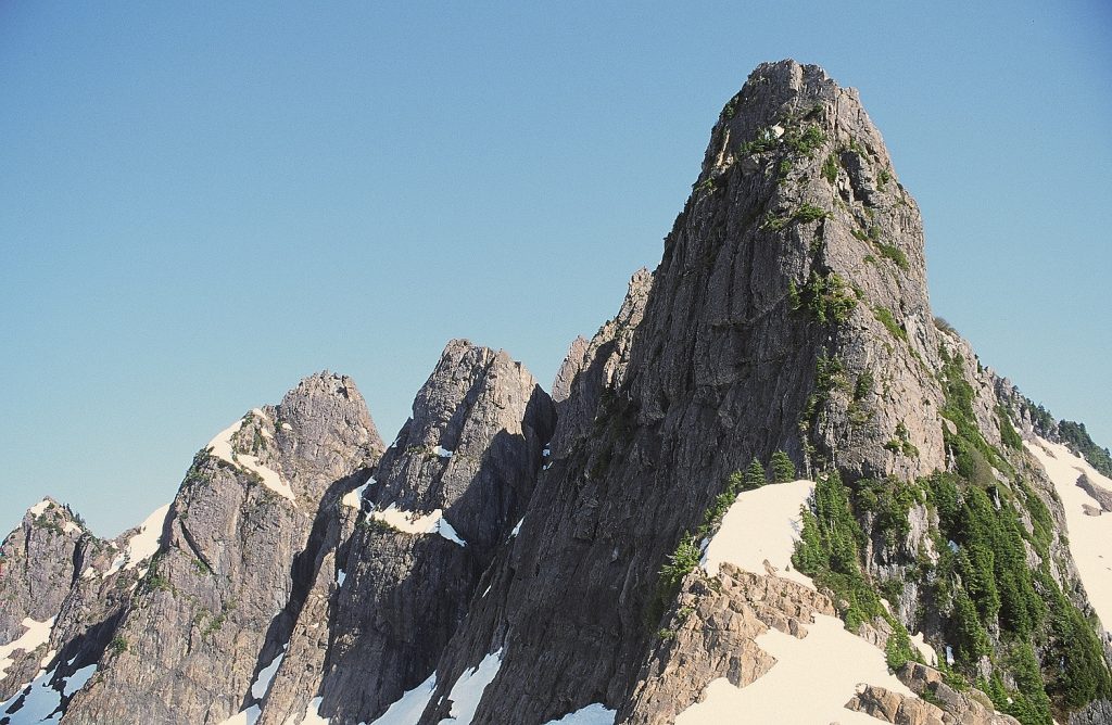
Early Sunday morning we started slogging upwards through wet bush for six hours to timberline, where a welcome sun broke through the mist, turning the meadows suddenly and brilliantly to the most idealized vision of a mountain landscape. A great variety of flowers were in bloom and without Dave Coombes, we had to call upon our combined botanical lore to identify them. We all established camp at my favorite snow patch on top of “false peak”. Soon afterwards, Nikki and I left for the Mackenzie Summit, reaching the top just in time to see Al and Tom begin roping down from their successful climb of Redwall Peak. A highlight of the trip was returning to camp – the whole scene bathed in the most outrageous sunset – silhouetting the Maitlands – flatting everything in a hushed purple glow, to contemplate and savour, then and now. The next morning, the pair from Victoria attempted Redwall Peak, Nicki wandered along the ridge to the north, and Tom, Al and I left for Flat Top. This was the last unclimbed pinnacle of the main group of six. Two or three hundred feet of class 3 maybe (a touch of three+ in places) brought us to the notch between Shadowblade and Flat Top. The next pitch had a couple of hard moves, that was not very long or exposed. Here, Tom decided to wait, while Al led the vertical section and delayed me up to the easy summit friction pitch. On top there was a group of rocks which could conceivably have been a cairn (but more likely not, we told ourselves)! We returned to camp, rested, and finished the long hot descent to the highway with daylight to spare. Beside being a beautiful and seldom visited area, there are lots of challenging rock climbs left. The north wall of Mackenzie Summit (at least 700 feet) seems especially worth a try. The more distant peaks in the Mackenzies [Sunrise Peak, Razorback, Poncho Peak and Ravenhorn] have no recorded ascents and looked like a lot of fun, but would require more than a three-day weekend.
Participants: Bill Perry, Al Harrison, Tom Emerson, Nicki Westarp and 2 guys from Victoria.
Flat Top and The Centaur from the Mackenzie Summit 2012 – Lindsay Elms photo.
Redwall Peak in winter – Sandy Briggs photo.
Redwall Peak with Flat Top and The Centaur in the distance – Sandy Briggs photo.
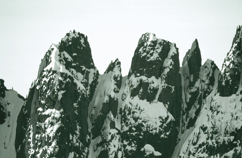
The Centaur, Witches Hat, Flat Top and Shadowblade – Sandy Briggs photo.
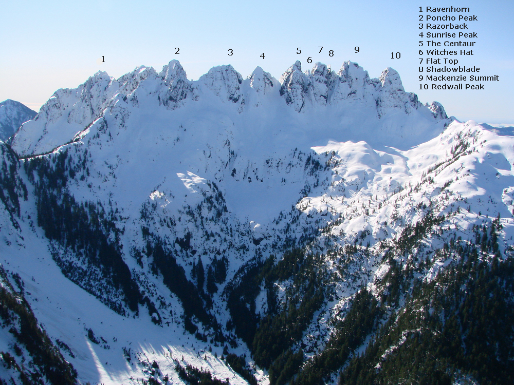
The whole Mackenzie Range – Lindsay Elms photo.
Malaspina Peak
From personal communication with Syd Watts and John Gibson to Lindsay Elms.
On 12 August 1977 John Gibson, Syd Watts, Alan Robinson, and Jim and Geoff Squarok drove up island and camped beside Malaspina Creek while Rick Eppler arrived the next morning at 6:30 a.m. Sunday morning just after Rick arrived the party left their vehicles. Syd Watts led them through the bluffs to the Northwest Ridge where they found the basin almost free of snow. After crossing the basin and traversing around to the north they reached a snowfield which took them up to a col between a minor summit to the east and the main summit. Here an easy scramble up the Northeast Ridge led them to the main summit [August 13] which had eluded them the year previous.
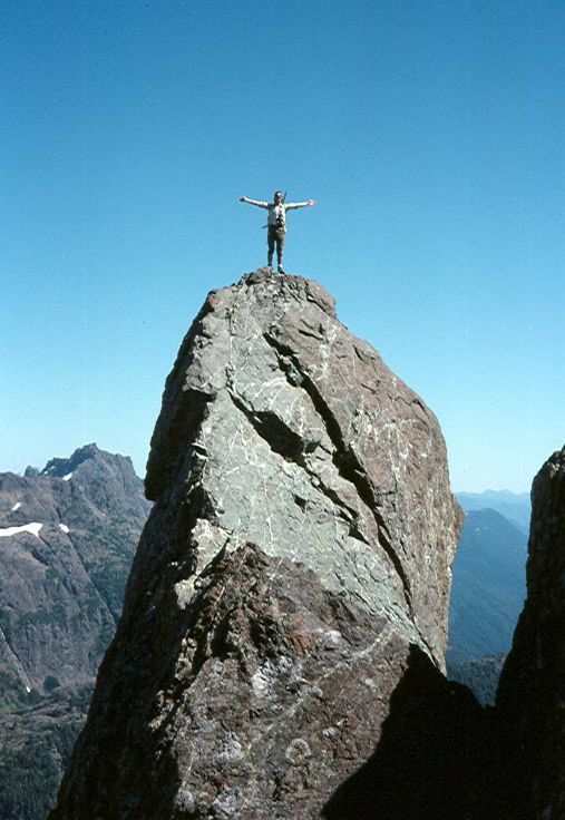
Rick Eppler standing on top of a gendarme on Malaspina Peak 1977 – John Gibson photo.
Alan Robinson, Steve Hinde, Gil parker and Rick Eppler on the southwest ridge of Malaspina Peak 1976 – John Gibson photo.
Syd Watts and Geoff Squarok on Malaspina Peak with Mts. Bate and Alava behind 1977 – John Gibson photo.
Steve Hinde, Syd Watts and Rick Eppler looking at Malaspina Peak from the south summit of Tahsis Mtn. 1976 – John Gibson photo.
Syd Watts looking at Tahsis Mtn. from Malaspina Peak 1977 – John Gibson photo.
Malaspina Peak from Steven Peak 2012 – Lindsay Elms photo.
The Victoria Climbing Scene
Reported in The Canadian Alpine Journal Vol. 61, 1978. p.84/85.
By Rick Eppler, John Simpson and Gil Parker
While Victoria is not known to climb as the Leavenworth of BC, a number of good practice rock training areas exist. Rumoured to be good areas are the Samsun Narrows, (west of the channel), and the Gordon Head Sea-cliffs. Data on these await authors who know the routes. But right in Victoria City a 30-foot cliff above Fleming Beach near MacCauley Point is very popular. Three short routes low Class 5 exist and a smooth overhang offers suitable practice terrain. Unfortunately, over climbing has loosened many of the good belay points but the major hazards are a paved asphalt walkway beneath the cliff, and many small boys kicking pebbles off the top! Fort Rodd Hill boasts good bouldering. When this military site was built it was thought that 75 degree opened-jointed rock walls provided protection for the gun emplacements. Actually, they yield firm holds for easy wall climbing. But beware, commissionaires have difficulty understanding any practices but walking on the manicured pathways. All of which has led us to the Humpback Road, ten miles west of Victoria. Mount Wells on the east side of the valley has long offered open cliffs of Class 4 climbing, suitable for teaching beginners’ techniques. Several climbers have put up new free and artificial routes on the adjacent buttress, notably Wallbanger (A3) by John Simpson. On the west of this valley is Mount McDonald which is probably Victoria’s main climbing patch. The face pictured lies about one mile southwest of the Goldstream Reservoir. The first and only route done for many years was the prominent crack on the left of the face. Then Doug Scott arrived on a lecture tour and put up his route in the middle of the cliff. This brought attention to the rest of the cliff, most of the new routes involving face climbing techniques with some poor protection.
Routes are short, ranging from 40 to 150 ft.
The Crack
First ascent by Godfrey Knox in the mid-sixties. Class 4 to base of the chimney, low 5th to belay plug in crack. Bushes here force you onto the nose to the right (5.4) and up.
The Flake
First ascent by John Molnar and John Simpson, 1977. Start 30 ft right of The Crack. Follow the underside of flake, then the side of the flake (5.7) to reach a belay under an overhang. Climb over lip and left (5.8) or traverse left and up.
Scott’s Route
First done by Doug Scott, 1975. Start 25 ft right of The Flake. Work up and right onto a horn. Up the backside of a mossy flake to a point 10 ft below an overhang, then left and up.
Stinger
First ascent by John Molnar and John Simpson, 1975. Start with boulders to the right of Scott’s Route. Climb up to a moss ledge, left onto Scott’s Route, then up and over left edge of the overhang (5.7). Traverse to the top.
Direttissima
First done by John Molnar and Mike Curran, 1977. Start on corner (5.7) 20 ft right of boulders. Climb straight up (low fifth class) to overhangs (A2) and up.
Garden
First ascent by Rick Eppler and John Simpson, 1975. Start 40 ft right of Direttissima. Follow a flora filled gulch and slabs (5.5) to the top. Nasty when wet.
Nose
First by Cliff Syroid and Brian Boswell, 1976. This lies between Garden and Gee Whiz. Follow the right of the Nose (5.7) to the top.
Gee Whiz
First ascent unknown, but the first rapid descent was made by its namesake, Frank Gee in 1976. Follow a crack (5.4) just to the right of the Nose to the top.
It is realized that this summary list only some of the areas known to climbers; those unreported will have to await revelation by their discoverers.
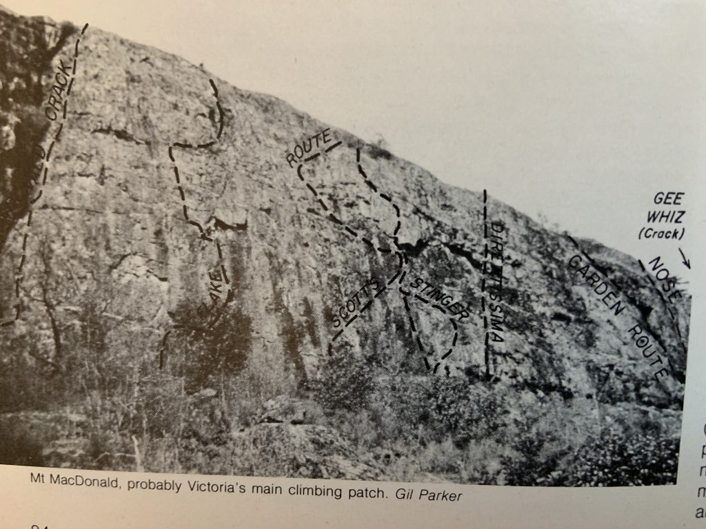
Mt. McDonald, probably Victoria’s main climbing patch – Gil Parker photo.
Two Rock Routes on Mt. Arrowsmith
By John Put
In July 1977 we put up two excellent rock routes on the rock buttress right of the standard Class 3 summit route on Mount Arrowsmith. The rock being a very solid, metavolcanic conglomerate offers the promise of more difficult and longer lines in the future. Our first line is an obvious groove which divides the summit buttress from top to bottom. From the notch at the start of the standard summit ridge both routes can be reached by traversing right along ledges or by dropping down to the snow basin. The second route is less obvious but goes unbroken between two grooves to the right side of the buttress, well left of the couloir.
First climb: 500 ft+, four pitches, 5.6. belay stances good, protection fair.
Second climb: 500 ft+, 5.7. No belay stances, no protection, so take your bolts or solo it. Perry Beckham and John Put. July 1977.
Mt. Colonel Foster
By John Put
Vancouver Island’s Elk River valley is becoming a climbers’ haven. Rambler Mountain has a new route on the north buttress (as far as the word goes). Mount Colonel Foster’s north tower has had a fine new route put up its north buttress. The line follows the righthand skyline as seen from Landslide Lake. Success was for Perry Beckham and his partner Scott Flavelle sometime in August 1977. The route is grade 4, 5.7 to 5.8. Culbert’s truly magnificent Mount Colonel Foster east face route has seen the possible second and third ascents. On 25 July 1977 Perry Beckham and I [John Put] walked up the Elk River valley and bivouacked at the Foster Glacier four hours later. Our intent was to climb the original east face route on Mount Colonel Foster. Our major difficulty was to negotiate the small “snow patch”, a small hanging glacier which threatened to avalanche. We attempted this section by surmounting a vertical ice pitch without crampons. The first section went okay but on the second, because of loud groans under our feet and a shifting snow bridge, we chickened out to the dreaded rocks on our right. This required a 5.8 finger traverse on wet rock below a dripping ice wall. Once off the traverse we followed mud covered slabs to the main ridge. Two fine rock pitches and a lot of Class 3 brought us to the first ridge crest. Then crossing a broken ledge system to the right, ascending an obscure chimney on our left, we managed to rejoin the main ridge. Climbing more broken rock with fifth class moves, we eventually bivouacked just beneath the summit at 9 p.m., after having climbed for some fifteen hours. The next day we traversed the south-west peaks and were off Foster in seven hours. Two climbers we had met the day before on the trail, also heading for the east face of Foster, apparently did not meet with such good fortune. Encountering a severe storm they were forced to make emergency bivouacs, remaining on the mountain for a number of days.
Three photos from the summit of Elkhorn (date unknown but in the early spring) – Ralph Hutchinson photos.
1978
ACCVI Executive
Chairman – Walter Latter
Secretary – Alan Robinson
FMCBC rep – Charles Rowley
Membership/Treasurer – Dave Tansley
Bushwhacker editor – Mike Sampson
Events:
January 13/14 – Scheduled ski-mountaineering trip to Brohn Ridge to be led by John Simpson.
January 14 – Joe Bajan, Ross Nichol and Richard ? (NZ) abort an attempt on the east face of Mt. Colonel Foster before getting onto the mountain.
January 15 – Scheduled trip to Green Mtn. to be led by John Simpson.
January 22 – Scheduled trip to Service Mtn. to be led by Walter Later.
January 28/29 – Board meeting of the Main Club to be held at the Empress Hotel.
January 28 – Scheduled trip to Cottonwood Creek to be led by Walter Latter.
January 28-31 – Joe Bajan and Ross Nichol make the 1st ascent of the Direttissima on the East Face of Mt. Colonel Foster.
January 29 – Scheduled trip to Mt. Arrowsmith to be led by Rick Eppler.
February 3-4 – Scheduled trip to the ACC Whistler cabin to be led by Gary Kirkham.
February 18/19 – Gil Parker, Dave Stevens and Richard Whittingham climb Elk Mtn (Olympics).
February 25/26 Scheduled trip to Mt. Becher to be led by Jim Weston.
March 3 – The club’s annual banquet at the Oak Bay Beach Hotel in Victoria. Fips Broda showed slides on his ascent of Aconcagua and Mt. Kenya. $8.00 per guest.
March 5 – Rick Eppler, Anne Brearley, Cliff Syroid and Gerry Dumas climb Mt. Landale.
March 11/12 – Dave Tansley leads a trip up Rainbow Mtn.
March 18/19 – Scheduled trip to Mt. Washington to be led by Doug Wylie.
March 21 – Doug Scott presentation on Mt. Everest/Mt. McKinley/The Ogre and Back at the Newcombe Theatre. Admission $3. Students and pensioners $2.
March 25/26 – Scheduled trip to Hurricane Ridge led by Jim Weston.
April 2 – Scheduled trip to Gemini Mt. to be led by Rick Eppler.
April 14 – Tim Auger gives a presentation on climbing Pumori at the Newcombe Theatre. Admission $2:50. Students and OAP $2.
April 15/16 – Scheduled trip to Mt. Myra. Walter Latter leader.
April 20 – Club meeting at the YMCA 880 Courtney St. Murray Foubister showed a film of his Austrian Ski Tour and Haute Route.
April 22/23 – Scheduled trip to Mt. Myra to be led by Walter Latter.
April 29/30 – Scheduled trip to Flower Ridge to be led by Charles Rowley.
May 20-22 – Jim Weston led a trip of eight people climbing on the Squamish Chief.
June 10/11 – Scheduled trip to Kings Peak to be led by Paul Erickson.
June 14 – Cliff Syroid and Gerry Dumas climb the south ridge of Mt. Arrowsmith.
June 17/18 – Scheduled trip to Mt. Angeles to be led by Jim Weston.
July 1/2/3 – Scheduled trip to the Mackenzie Range to be led by Gary Kirkham.
July 15/16 – Scheduled trip to Squamish to be led by Jim Weston.
July 15-23 – Scheduled Strathcona Traverse to be led by Gil Parker.
July 23-30 – Scheduled trip to the Bonanza Range to be led by John Gibson.
August 5/6/7 – Scheduled trip to the Comox Glacier to attempt The Red Pillar to be led by Syd Watts.
Summer – Al Harrison climbs Elkhorn Mtn. solo in just over 5 hours.
August 19/20 – Scheduled trip to Matchlee Mtn to be led by Alan Robinson.
August – Joe Bajan and Paul McEwan climb Mt. Colonel Foster via the Snowband.
August 26/27 – A work party on the Price Creek trail.
August – Ralph Hutchinson, Roger Neave, Hugh Neave, Joe Bajan, Paul McEwan and Dave Fisher climb in the Cordillera Blanca in Peru making 1st ascents near Nevada Champara.
September 2-10 – Scheduled trip to the Haihte Range to be led by Gil Parker.
September 17 – Scheduled trip to Mt. Whymper to be led by Cliff Syroid.
September 23/24 – Scheduled trip to Squamish to be led by Jim Weston.
October 7/8/9 – Scheduled trip to Forbidden Peak (Olympics) to be led by Fdave Tansley.
October 14/15 – Dave Tansley and Cliff Syroid climb Baby Munday Peak.
October – Schoen Lake Provincial Park established.
Sandy Briggs and Derek Belsham climb in Auyuittuq National Park on Baffin Island.

Sandy Briggs on summit of Umik Peak with view to Caribou Glacier and Summit Lake, Akshayuk Pass, Auyuittuq National Park, Baffin Island 1978 – Sandy Briggs photo.
Strathcona Park- much abused and generally exploited for its mineral wealth, is threatened yet once more. The 3rd phase of Pacific Rim Park is yet to be negotiated and government bodies are again talking timber trade-offs for increased parkland on the coast. As Strathcona Park is the lonely real provincial timber reserve the government has to negotiate with on the island, there is strong indication as to where compensation to MacMillan & Bloedel and B.C. Forest products for parts of T.F.L. 21 and 22 respectfully will come from. The Section Executive has written to the Government (and Opposition Parties) requesting consideration of several points related to Strathcona Park.
Have we met our Waddington? The Feds are casting an eye at Mt. Waddington as a potential national park. It is not just a rumour, as even the Provincial Parks branch officials admit it. The Federation of Mountain Clubs of B.C. has mixed feelings: The fast-encroaching loggers who are now on Waddington Glacier moraine and at timberline level on Jubilee Mountain can be held in check if the area becomes a park; on the other hand, it means Calgary Federal Parks offices long distance bureaucracy complete with aircraft controls, climbing permits, backpacking permits and other roadblocks impinging on climbers’ freedom. How do we feel?
The first guide to Vancouver Island rock-climbing area is now being researched with Jim Weston and John Simpson.
Treasurer’s Statement: 1978
Receipts:
Opening balance 834.69
Dues: Section Members 190.00
Life Members 57.00
Main Club Aff. 317.40
Pieps radio rental 25.00
Pumori lecture balance 124.14
Doug Scot Lecture balance 643.47
Interest 17.70
2209.40
Expenses:
Island Bushwhacker and 1978
Interest Questionnaire 647.84
Federation dues 50.00
A.C.C. General meeting 1977 50.00
Wine and cheese 64.92
A.C.C. Annual dinner subsidy 33.60
A.C.C. Gen. meeting deposit 30.00
876.36
Closing balance 1333.04
Membership dues:
Section affiliates $6
Life members $4
Section library begins with the generous donation of material by Joyce Clearihue.
Section member Murray Foubister is awarded the Silver Rope Leader award. Presented by Gil Parker.
Buttle Lake: The Beauty That Died
Or Was it Public Apathy That Killed Her?
Reported in The Daily Colonist The Islander section, Sunday March 5, 1978. p.6&7.
By Ron Park
In 1934 Buttle Lake lay 11 miles by trail from the end of a rough road that petered out at Walter Sutherland’s cabin on Upper Campbell Lake. Thence the trail led through virgin stands of fur and cedar. The mossy forest floor was starred with trillions, yellow violets and lady slippers. Always the river, newly born in the big lake, ran with youthful vigor on one’s right hand. Trails end was a large log cabin fronted by flowering dogwoods. The row boats and scores of mice shared a seldom broken tranquillity. I lowered my backpack board to the cedar floor and looked around at the first of several rooms of the so-called government cabin. I saw a stove, a box bed, a table covered with soiled oil cloth. I leafed through the old exercise book that served as a sort of visitor’s registry.” God’s most beautiful creation”; “this lake is the best we have ever seen”; “hike to a small lake across the river … it was full of big-!” I was to agree with all of these verdicts in a total of nearly six months of pure happiness spent on the banks of this lovely water. Like a sword-cut, narrow and deep, the lake’s surface then was a peculiar greeny-blue color, the ancient merging of sky and untouched forest. Half a dozen streams fed the lake. Four miles away Wolf River entered, and near this spot a group of cabins stood beneath the shadow of 6800-foot Mount McBride. Once a Mr. Titus, a Washington D.C. lawyer had owned this camp [Camp Alicia], to which he brought an invalid son, but now the cabins belong to Will Reid of Long Beach, California. His caretaker, Con Reid (no relation), was one of the lakes to permanent residents. The other, across the lake, was Harry Rogers. I rode slowly across Wolf River’s outlet; the trout fly drifted down and across the rippling water. Came a jerk and sudden battle as a strong cutthroat seized the feathered lure and I happily drew him to the boat. The oars dipped steadily as the boat slowly followed the west bank. There was Marble Bay where a thin veil of snow water fell past a weathered outcropping of marble. Next Phillips Creek with notable fishing at its pebbly delta. Phillips Creek … memory indeed holds the door to the past wide open. Once when trolling in the deep, a fish took the small silver spinner and was lifted in after fighting well. This was a very unusual Dolly Varden, perhaps 14 inches long, his whole-body shimmering with a strange golden wash in which the widely spaced spots gleamed like orange stars. I was glad to release him unharmed. Almost at the long lakes ending, Myra Creek plunged wildly into a perfect rock basin before a short run brought it to the lake. It was not far to the lakes upper end, that’s where Price Creek abruptly crossed its gravel bar and disappeared into a flooded rift valley. Here a pleasant surprise was awaiting me, for I was to hook stout little landlocked salmon, as silver in color and as red flashed as any brave grilse caught in the salty sea. In 1938 I lived for two months at this wonderful spot, and caught many a pair of these stout little 12-ounce fighters. At Price Creek I lived in a tiny log cabin built in 1911 for government surveyors. It lacked floor and door, that I concocted a stove from three gasoline cans, complete with oven, and settle down in primitive comfort. Above me lay an untouched natural paradise. Even in June the snow lay deep on the ridges of Vancouver Island’s heart, a rugged backdrop of purple rocks and billowing snow slopes dominated by the Comox Glacier. It was in this wilderness that I saw the only ptarmigan I have ever met on the island. The tracks of the elk lay thick around the weather-beaten shack and the lake’s shallows were dimpled with craters where the big deer had uprooted water plants to munch the juicy roots. Cougar prints and wolf tracks crisscrossed the snow slopes as these hunters ranged through the lonely glades, the mountain meadows. This country at the lakehead was as perfect as nature could contrive. Today I’m saddened by the fact that it is impossible for me to return to a certain crystal-clear pool in Price Creek a short way upstream from the lake. For me this single body of slowly moving water epitomized all of British Columbia’s native beauty, all that I have loved in the wonderful island, this wonderful province.
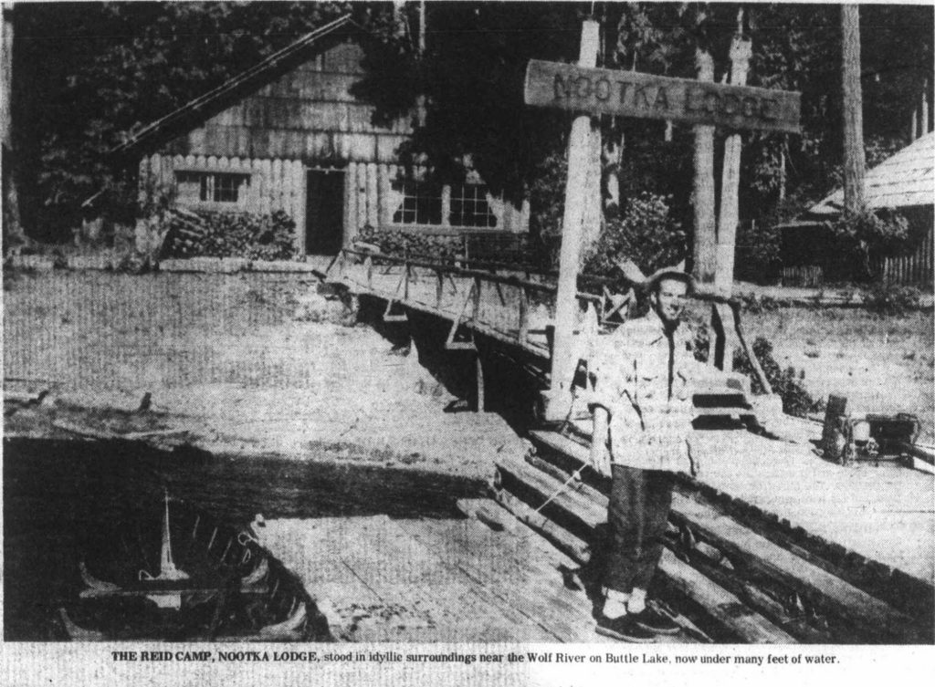
THE REID CAMP, NOOTKA LODGE, stood in idyllic surroundings near the Wolf River on Buttle Lake, now under many feet of water.
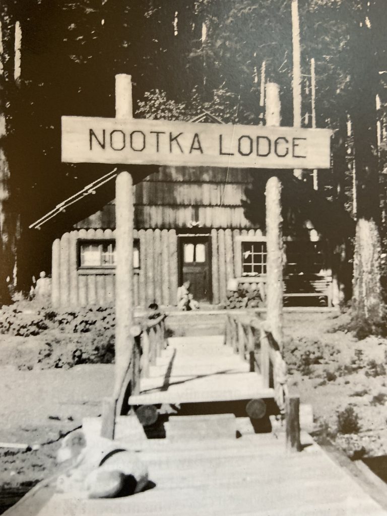
Nootka Lodge
Doug Scott Slide Show
Reported in The Daily Colonist Friday March 17, 1978. p.11.
Mt. Everest/Mt. McKinley/The Ogre and Back, a lecture-slide show by British climber Doug Scott, presented by the Alpine Club of Canada, Vancouver Island section, Newcombe Auditorium, Provincial Museum, 601 Belleville St., 8 p.m. Tuesday March 21. Admission: $3, students and pensioners $2.
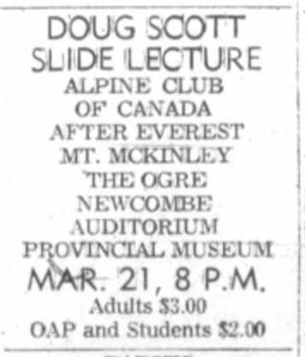
Doug Scott Slide Lecture, March 21, 1978. Adults $3.00, OAP and Students $2.00.
Pumori Slide Show
Reported in The Daily Colonist Wednesday April 12, 1978. p.33.
A lecture-slide show by Banff climber Tim Auger, member of the 1977 Canadian Himalayan expedition to Pumori, Mount Everest satellite, will be presented at 8 p.m. Friday in Newcombe Auditorium, Provincial Museum. Admission charge is $2.50 for adults and $2 for students and pensioners; tickets available at A.B.C. Recreational Equipment, 564 Yates, Hillside mall ticket booth, or at the door. The event is being presented by the Vancouver Island Section of the Alpine Club of Canada.
Helicopter Lifts Comshell
Reported in The Daily Colonist Saturday April 8, 1978, p.52.
It looks like something designed for outer space, but actually it’s a weatherproof shelter for CP rail’s new radio repeater equipment, designed to improve railway communication between Nanaimo and Courtenay and Parksville and Port Alberni. Called a Comshell, the unit was lifted by helicopter to the isolated 1590-metre peak of Mount Cokely, near Port Alberni. The unit is 8.4 metres tall and protects two battery-powered radio repeaters, aerials and other equipment, reducing maintenance to once a year.
Skeleton Is Discovered
Reported in The Daily Colonist Section Two Thursday October 19, 1978. p.13.
A skeleton found last week on a steep ridge at the north face of Mount Septimus by a 15-man Provincial Emergency Program search and rescue team is thought to be that of 20-year-old Gary Wayne Bresseier, who went missing in July, 1977, when he separated from his hiking companions to take a short cut across a valley in Strathcona Park. The bones were found in two locations about 50 yards apart on a small level section of the cliff. P.E.P. members were called back for the search last week after a group of hikers discovered equipment and personal effects identified as belongings to the missing man on a snowfield at the base of the cliff. The original search was called off in August 1977, after an intensive search by the same rescue team turned up only some fishing equipment and a hat in Price Creek at the base of the cliff, as the area was covered by a 15-foot-deep snowfield.
Direttissima
Reported in The Canadian Alpine Journal Vol. 62, 1979. p.37/38.
By Joe Bajan
Two years after the discovery of the ice climb, Joe Bajan, Ross Nichol, and a New Zealander by the name of Richard, set off to do a 3200-foot Direttissima ascent of the east face of Mount Colonel Foster. Due to poor conditions we had to abort the climb before even setting foot on the mountain. The seven-mile hike to the mountain took us two days. Ross and I came back two weeks later and accomplished the previous two-day journey in 4 1/2 hours. By the close of this day, we were already about 400 feet up the wall with a further 200 feet of fixed rope in place. After a comfortable night in an ice cave, we started jumaring up the fixed line. The new lead of the day was on the first crux, 600 feet of vertical and near vertical ice. Running out 300 feet leads on ice of this angle was extremely tiring and, to worsen matters, spin drift avalanches continuously cascaded upon us. While jumaring on this pitch one of Ross’s crampons went tumbling off to the glacier below. Without much discussion we decided to keep on going. I was to do the leading while Ross with the heavier pack would second, jumaring when required. The day closed with us about halfway up the face with a further 100 feet of fixed rope in place again. In an ice cave barely large enough for one we both somehow cramped in. With the equipment hung outside we couldn’t help but think about the predicament we would be in if it fell away. After an uncomfortable night we forwent breakfast and hot drinks in exchange for an earlier start. With frozen feet and hands we set off jumaring. A few clouds appeared telling us of a storm approaching. After a few pitches we stood under the second crux, a 500-foot band of water ice as steep as the first one. The climbing was very difficult and protection was impossible in the thin ice. Above this ice band the mountain eased off, then shortly it allowed us to climb for one lead without the need of a belay. The last 300 feet to the summit col proved to be more difficult than expected. The slope was about 55 to 60 degrees, with two feet of overlaying powder snow which had to be cleared away to firmer snow beneath. This was the most unnerving part of the climb as due to the unstable snow protection was impossible. Ross, having only an ice axe in powder snow for a belay, didn’t help matters either. It was already overcast as we reached the summit col at 1 p.m. our plans were to traverse south over the summit to the east side escape route but our way was barred by thin and dangerous ice feathers which encrusted the summit ridge. We managed to reach a point about 20 vertical and 200 horizontal feet from the summit. We then opted for the west side escape route but again the ice feathers barred our way. We had no choice but to descend the vertical bowling alley. This escape route had only been attempted once before. The party turned back due to the stone fall and, with the steepness, fearing hanging rappel stations. With a dozen bolts and three drills bits we felt confident of success. Snow had already started to fall as I broke the drill bit on the first hole. A few rappels later another drill broke. Being hundreds of feet from the bottom with only one dull drill bit left gave us an uneasy feeling. The mountain was starting to take its toll – nerves were getting edgy, falling snow and darkness surrounded us, fatigue was felt. I was only able to swing the hammer three times between rests. While this drill was being driven in, it’s shattered some of the surrounding rock leaving a dicey looking anchor. We decided to “go for it” anyway. After tying off the bolt, the nut was tightened to prevent the sling from slipping off. But while doing this the bolt popped out of its hole. Fortunately, we were able to find another anchor and the last few rappels were completed safely to the bottom. It was now completely dark but luckily had stopped snowing. The climb up to the north col was done in a drunken like stupor – stumbling and falling over seemed almost normal. We reached the col in a sad and tired state. Having been without water and hot food for the past 28 hours we were unable to continue. After drowning our thirsts in hordes of water and tea, we spent an incredibly uncomfortable night. The only thing I could think about all night were the Hot Springs I was going to visit the following weekend.
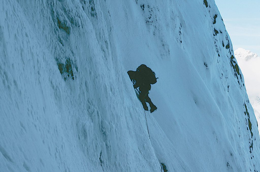
Ross Nichol on the east face of Mt. Colonel Foster 1978 – Joe Bajan photo
1979
ACCVI executive:
Chair – Mike Sampson
Secretary – Gary Kirkham
Membership/Treasurer – Dave Tansley
Bushwhacker editor – Jim Weston
Programs – Paul Erickson
FMCBC rep – Tim Leadem
Events:
January 28 – Walter Latter led a trip to Mt. Landale via Sherk Lake.
February 2 – Heavy snowfall in Victoria limited the number of attendees at a club meeting. Roger Neave showed slides of his 1934 journey to Mt. Waddington.
February 10/11 – Scheduled trip to Hurricane Ridge to be led by Jim Weston.
February 1-18 – Scheduled trip to Mt. Baker or Shuksan ot be led by Mike Sampson.
February 17-24 – Section members attended the McGillivary Ski Camp including Alan Robinson and Dave Tansley.
February 21 – John Roskelley gave a slide show on K2 at the MacLaurin Building at UVIC.
February 23-26 – Scheduled trip to Mt. Hood to be led by Gil Parker.
March 11 – Scheduled trip to Green Mtn. to be led by Alan Robinson.
March 23 – The annual banquet dinner at the Captain’s Place, 309 Belleville St. $9.00 per guest.
March 25 – Scheduled trip to Gemini mtn to be led by Rick Eppler.
March 31-April 1 – Scheduled trip to Mt. Baker or Shuksan to be led by Mike Sampson.
April 7/8 – Scheduled trip to Mt. Sphinx in Garibaldi Park to be led by Dave Tansley.
April 20-22 – Scheduled trip to Flower Ridge to be led by Jim Weston.
May 6 – Club trip to Mt. Tuam led by Karel Hartman.
May 19 – Rick Eppler led a trip to the Maitland Range with Rob Macdonald and Tom Emerson.
May 19/20 – Gary Kirkham led a trip to the Elk River to attempt the southern peaks of Mt. Colonel Foster but were fogged out.
May 27 – Rick Eppler Rob Macdonald, Karel Hartman, Dave Hobill, Brian Hart and ben Peterson climb Kings Peak.
May – A unique screening at the YMCA of the 1925 movie about the first ascent of Mt. Logan with a soundtrack in 16mm.
June 3 – Mike Sampson led a trip to Klitsa Mtn.
June – Paul Welle and Steve Howie climb Mt. Assiniboine by the northeast ridge.
June – Jim Weston leads an ice climbing instruction course on Mt. Arrowsmith.
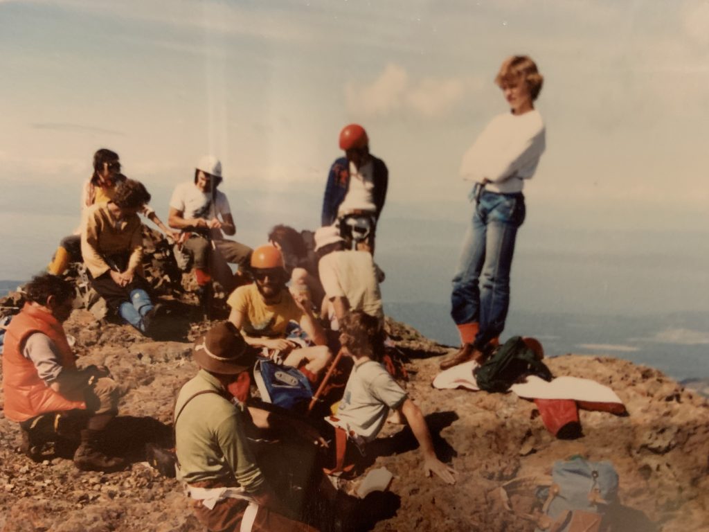
On the summit of Mt. Arrowsmith. Albert Hestler in felt hat, Brian Money in orange helmet and Jim Sandford standing on the right – Brian Money photo.
June 22 – New route climbed on the south shoulder of the main crack on Mt. McDonald by Paddy Millar, Dennis Burke and Mike Siska.
June 23/24 – Tim Leadem led a trip to Mt. Deception in the Olympics with Brian Money, Carole Leadem and Derek Hitchman.
July – 13-16 – Gil Parker led a family camp on Forbidden Plateau.
September 16 – Mike Ounsted and Curt Nyquist climb Mt. Maxwell on Saltspring Island.
September 20 – At the club meeting John Pratt gave a slide presentation on Mt. McKinley.
October 18 – The Club General Meeting at UVIC. Mike Sampson showed a film of a spring skiing adventure from the 1977 ACC ski camp near Mt. Robson and a special slide presentation by Jim Weston called Climbing the Granite Ocean.
October 29 – Cliff Syroid led a trip up Mt. Whymper.
November – The Sections annual general meeting held at the Oak Bay Beach Hotel. Guest speaker Dr. John Hayward, inventor of the UVIC Thermofloat Jacket speaks on hypothermia. $2.50 per person.
December 30 – Scheduled trip to Mt. Cheam to be led by Rick Eppler.
The proposed book Island Guide to Rock is cancelled.
A feasibility study concluded that at the present time a guide would be limited in scope. Due to the few ‘showings’ of solid rock the guide would end up accentuating the problems of use already being experienced. It seems the Island climbers who are really ‘into rock’ take it for granted they will have to commute to the ‘real’ stuff at Squamish.
Island Hut Proposal.
I obtained permission from the Board to initiate a feasibility study to set up a main club hut on the Island at the Mt Washington Ski Area. What do you think of the idea? Would you like to become involved in such a project? Whatever your ideas, questions, or criticisms, I would appreciate your writing me. If you would like to attend the next Executive meeting to hear more of the discussion on this, call any of the Executive members to find out the next time and place. I will be organizing a Hut Development Committee in the near future to commence the feasibility study and I’ll report on our progress from time to time. Don’t forget, this is a participative club depending solely on your support and enthusiasm.
Mike Sampson, Chairman.
Changes in Publishing Format.
As the information medium among our section members, the Island Bushwhacker is making a major shift in publishing format. Due to a variety of factors, it has become impractical to include trip reports in each bi-monthly issue. We are going to continue sending you a newsletter but it will contain only current material and upcoming concern to the membership, and special news items. The trip report will be published in a similar format to previous recent issues of the Bushwhacker, but this will be twice-yearly special publication. This will give us the opportunity to make it more attractive and the increased size of the bi-annual issue will improve its value as a record of coastal mountaineering. The twice-a-year issue will also create an editorial schedule allowing more photographs, etc, to appear with trip reports. It has always been a problem to process photos for the newsletter immediately after a given trip.
Section dues: $6.00
YMCA Outdoor Courses
Reported in The Daily Colonist Sunday April 29, 1979. p.20.
Black and white ad for YMCA Victoria outdoor programs.
Vancouver Island Section Activity
Reported in The Canadian Alpine Journal Vol. 63, 1980. p.79.
By Jim Weston and Mike Sampson
Since our last report (1977) there has been a big increase in rock climbing at Fleming Beach, Mount McDonald and Mount Wells. Attracting more climbers from the Victoria area, mostly outside our membership, the friable rock continues to suffer at the hammers of a few high impact climbers and even the firm rock of Fleming is showing the strain of entertaining dozens of people on a sunny weekend. With the Section, partly spurred by spring mountaineering courses, the fine rock of Squamish Chief has become more attractive in spite of the travel logistics – even for people new to rock climbing. There is simply nothing like it on the island. A rock-climbing guide to the island was considered but after intense research in local pubs it was agreed that the combination of access into private land holdings and fragile routes would continue to be better approached through in person introduction by informed locals. Meanwhile small fragments of Squamish rock are often smuggled back to Victoria whereupon the uninitiated can smear a toe of their EBs in anticipation of their first visit to mainland granite. There were reconnaissance’s of rock-climbing potential in the sub alpine Mackenzie and Maitland Ranges, led by Gary Kirkham and Rick Eppler. A presumed first ascent was made of “Bonanza Peak” on the north east coast of Vancouver Island. Family trips were made to Mount Tuam and the Forbidden Plateau region. The largely sub alpine character of the island, particularly in eastern Strathcona Park, has a lot of potential for introducing children to the values and pleasures of mountain country and at the same time offering parents many practical and scenic objectives that are relatively close to trailheads.
“Bonanza Peak”
By John Gibson
In 1976 we climbed the south peak of Mount Ashwood (1744m), with the name and survey point on it, we only realized on reaching that summit that the north peak is actually higher. A careful counting of the map contour lines (sheet 92 L/ 7) confirm this and now, nearly three years later, the north peak has graciously accepted our advances. We drove up the new North Island Highway in pouring rain on the Friday evening of 16 June 1979, and camped by Bonanza Lake at a Crown Zellerbach campsite. Saturday dawned moist and misty and we were in no hurry to get going. After some to-ing and fro-ing along logging roads looking for the best approach to our mist enshrouded mountain, we parked the Land Rover on a spur from CZ’s main road south and took to the bush about three miles west of our summit. The lower open slopes, pleasant open forest with no bushwhacking, led beautifully and smoothly up a ridge to timberline, and about 2 p.m. we reached the snowy dome and had a brief glimpse of our summit through a hole in the mist. On along a snowy ridge with some down and up again and at 6 p.m. we were at the base of the final rock peak, in bright sunshine. Here Syd sat on a rock and worked out a much better way back to the car than the way we had come while the rest of us reconnoitered the rock ledges leading toward the summit. We rejoined Sid at 6:45 p.m. and followed the route he suggested, down to the Bonanza River and then along a bench beside it, in spruce and hemlock forest where the going was good, as he expected. We reached the Land Rover at 9:15 p.m. and were soon back in camp. Next morning was clear and fine and we were away at 6:30 a.m., going up the north side of Bonanza Creek to about 692750 on the UTM grid of our map, and from there turning up to the col between our peak and one north of it. With some minor variations up the route, we came down the day before, we reached the bottom of the final rock tower and roped there about 12:30. Climbing was easy but exposed at first as we traversed ledges around the west face of our peak to gain the south ridge, up which we proceeded without difficulty, reaching the summit at 2:10 p.m. It is a large detached block which looks as if it might roll down towards Johnstone Strait one of these days. We built a cairn and left a record in it. After basking in the sun up there for an hour or so, we descended by the same route, getting back to the Land Rover at 7:15 p.m. The summit, at 706756 on the UTM grid, is I think the only one above 5800 feet (1768m) in the Bonanza Range, so it seems odd that the surveyors had ignored it, placing the name Mount Ashwood on its lesser sister half a mile to the south. To give it its due, our peak should perhaps be named Bonanza Peak.
Participants: Rick Eppler, John Gibson, Ben Peterson, Syd Watts.
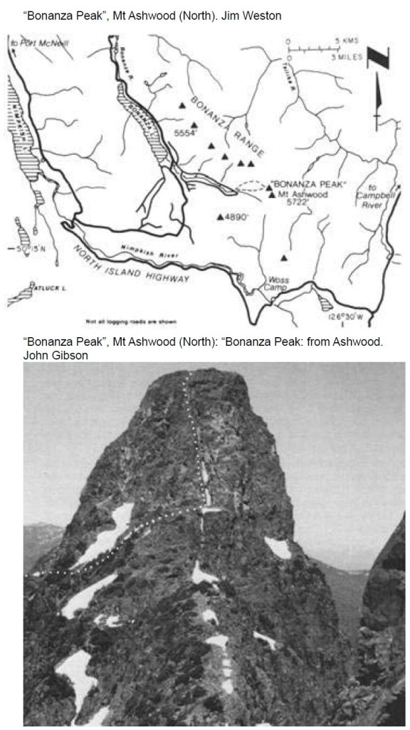
Bonanza Peak Map and Route.
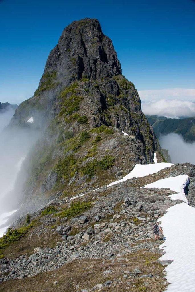
Bonanza Peak from the slopes of Mt. Ashwood 2016 – Matt Lettington photo.
The Next Decade: 1980 – 1989
For more history, adventures and exploits of Alpine Club members, please visit our archive of Island Bushwhacker Annuals. The Island Bushwhacker Annual archive has digital editions from 1993. But you can search for information as early as 1973 using the Google-enhanced search field.