Road Access to Trailhead
Marion Main Forest Service Road provides access to the Cobalt Lake trailhead. The turnoff is 53km from Port Alberni ~5.6km after Sutton Pass. The trailhead is 9.6km from the highway. Cobalt Lake Trailhead is 400m after the large clearing that is used for the heli staging area near the top of the hill. This area can also be used for parking if there is no space at the trailhead.
A 4×4 or AWD vehicle is required for this gravel road because it is steep and rough in sections. Vehicle clearance can be an issue, cars have been damaged. Please do not try to take a 2WD vehicle up the road because 2WD vehicles often spin their tires on hills which make the road even rougher. The steepest and longest hill is located at 8km.
Cobalt Lake Trail
The Cobalt Lake Trail is the standard approach up 5040 Peak. If parking at the trailhead, the trail starts 20m back (north) from the direction you drove in. The trail gains 700m elevation and 2.5km horizontal. It generally takes 2 to 3 hours to reach the hut. The rough trail is continuously steep with the only flat section being along Cobalt Lake. There are two fixed ropes up short rock steps. The trail has several slippery sections so appropriate footwear should be worn. Please allow plenty of time to reach the hut before dark. To stay out of the doghouse, we suggest that you do not describe the trail as “easy” to your significant other. It’s STEEP!
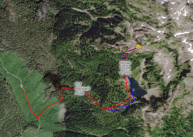
Download GPS tracks for Cobalt Lake Trail, Cobalt Lake – Winter Up and Summit trail
Access with Snow (November to June/July)
Access in winter can be challenging. What takes 1.5 – 3 hours in summer can take 6 – 14 hours in the snow, the days can be very short in mid-winter, plan accordingly. Marion Main is not ploughed so you may need to start by skiing/hiking 9.5 km up the logging road. If travel conditions are good expect to take about 3 hours, if you are breaking trail if can take twice that time.
The standard winter is basically the same as the standard summer Cobalt Lake trail with some minor variations (see above). Some flagging may be visible on the trail but you should either know the route well or have appropriate navigation tools. Even getting up to the old growth from the trailhead can be a challenge in some snow conditions. There is rarely enough snow in the old growth to ski so a bootpack is required, in good conditions this takes less than 1 hour.
Although it is possible to reach the hut without crossing any significant avalanche slopes you should have the training and gear to deal with potential avalanche conditions. Check the avi conditions before you go and if you want to do any exploring beyond the hut you must have avi gear and knowledge.
 Possible ski lines on 5040 Peak